

石油与天然气地质 ›› 2023, Vol. 44 ›› Issue (3): 539-552.doi: 10.11743/ogg20230302
朱红涛1( ), 徐长贵2, 杜晓峰3, 刘强虎1, 孙中恒1, 曾智伟1
收稿日期:2023-02-13
修回日期:2023-03-19
出版日期:2023-06-01
发布日期:2023-06-05
第一作者简介:朱红涛(1976—),男,教授、博士生导师,层序地层学、沉积学、地震沉积学。E-mail: 基金项目:
Hongtao ZHU1(), Changgui XU2, Xiaofeng DU3, Qianghu LIU1, Zhongheng SUN1, Zhiwei ZENG1
Received:2023-02-13
Revised:2023-03-19
Online:2023-06-01
Published:2023-06-05
摘要:
陆相盆地古源-汇系统定量重建、级次划分及耦合模式是还原深时盆地剥蚀和沉积过程的重要研究内容。陆相盆地古源-汇系统物源区定量重建难点主要包含古地貌重建和古水系重建。古地貌重建新技术的发展提出了基于剥蚀区、超剥区(剥蚀和超覆作用共同作用区)和超覆区为框架,残余地貌重建、差异沉降校正、超剥区恢复、剥蚀区恢复和沉积古地貌恢复流程的“三区五步”恢复方法。古水系重建方面提出了基于ArcGIS系统的古水系定量恢复和拾取方法。陆相盆地古源-汇系统级次划分的代表方法是“三线三级”法,关键是拾取分水岭、分水线和脊线,进而划分一级、二级、三级古源-汇系统。基于重建的古源-汇系统物源区流域单元与沉积区沉积体的面积、形态组合、配置关系,建立了“哑铃型”“球拍型”“奖杯型”和“标枪型”4种古源-汇系统耦合模式。研究成果对古源-汇系统定量化研究和勘探目标评价、预测具有一定的参考价值。
中图分类号:
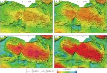
图1
渤海湾盆地沙垒田凸起古近纪古地貌恢复结果a. 东三段沉积时期;b. 沙一、沙二段沉积时期;c. 沙三段沉积时期;d. 孔店组-沙四段沉积时期"

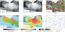
图2
渤海湾盆地沙垒田凸起古水系自动拾取流程a. DEM栅格图;b. 填洼;c. 流向分析,流量计算和阈值设置;d. 河网分级;e. 古水系恢复;f. 流域单元自动拾取"
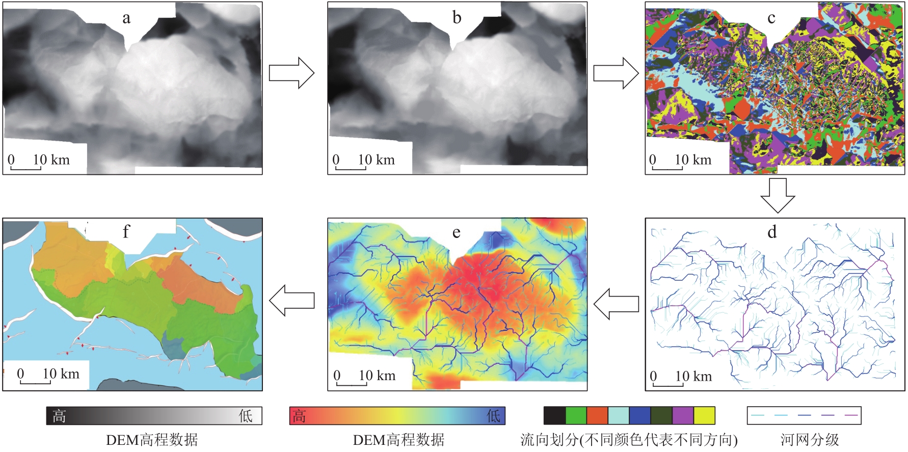
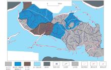
图3
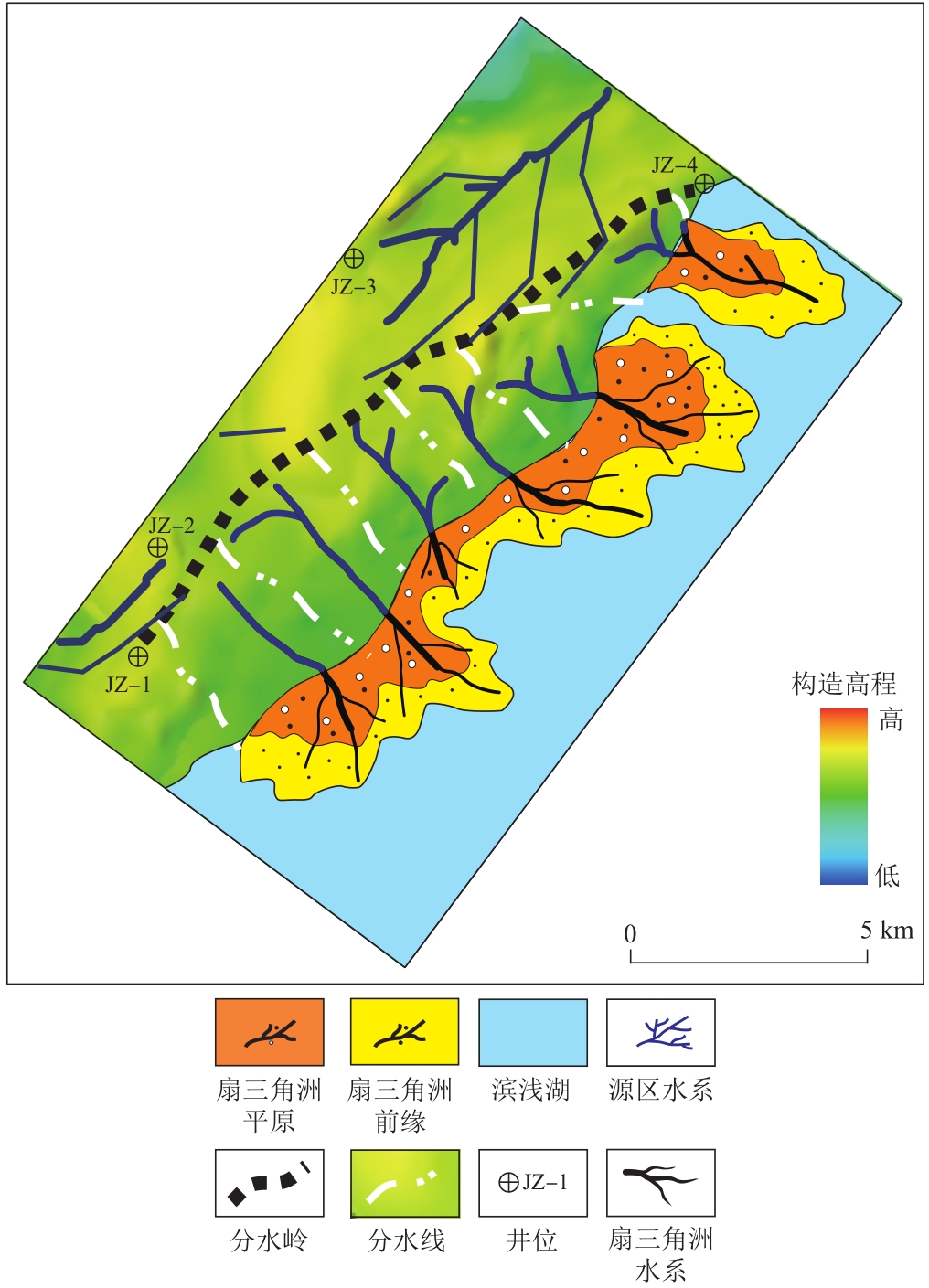
渤海湾盆地沙垒田凸起沙三段沉积时期古水系分布特征(a—r 为划分的18个流域单元编号)"

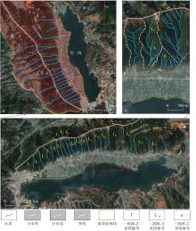
图4
“三线三级”源-汇系统单元划分[64]a.一级源-汇系统;b. 二级源-汇系统;c.三级古源-汇系统"


图5
源-汇系统耦合模式示意图a.哑铃型;b.球拍型;c.奖杯型;d.标枪型"
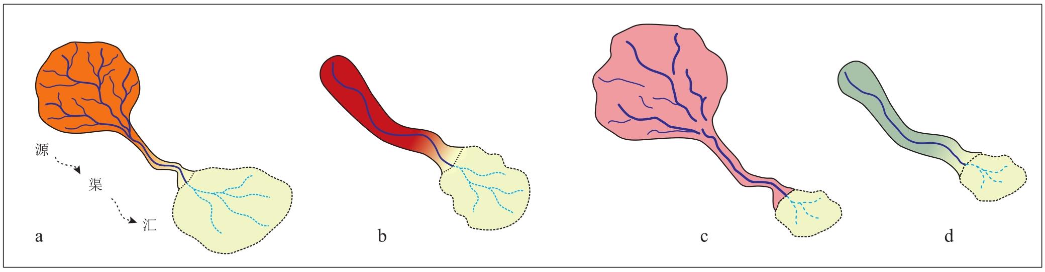

图6
渤南低凸起古近纪球拍型和哑铃型古源-汇系统耦合模式"

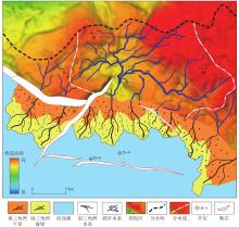
图7
沙垒田凸起古近纪奖杯型古源-汇系统耦合模式"

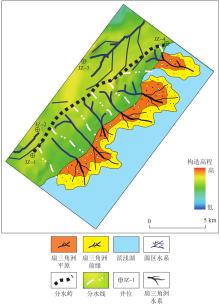
图8
辽东低凸起古近纪标枪型古源-汇系统耦合模式"
| 1 | HELLAND-HANSEN W, SØMME T O, MARTINSEN O J, et al. Deciphering earth’s natural hourglasses: Perspectives on source-to-sink analysis[J]. Journal of Sedimentary Research, 2016, 86(9): 1008-1033. |
| 2 | 杨元合, 石岳, 孙文娟, 等. 中国及全球陆地生态系统碳源汇特征及其对碳中和的贡献[J]. 中国科学: 生命科学, 2022, 52(4): 534-574. |
| YANG Yuanhe, SHI Yue, SUN Wenjuan, et al. Terrestrial carbon sinks in China and around the world and their contribution to carbon neutrality[J]. Scientia Sinica(Vitae), 2022, 52(4): 534-574. | |
| 3 | WALSH J P, WIBERG P L, AALTO R, et al. Source-to-sink research: Economy of the earth’s surface and its strata[J]. Earth-Science Reviews, 2016, 153: 1-6. |
| 4 | 刘强虎, 朱筱敏, 李顺利, 等. 沙垒田凸起西部断裂陡坡型源—汇系统[J]. 地球科学, 2017, 42(11): 1883-1896. |
| LIU Qianghu, ZHU Xiaomin, LI Shunli, et al. Source-to-sink system of the steep slope fault in the western Shaleitian uplift[J]. Earth Science, 2017, 42(11): 1883-1896. | |
| 5 | 李顺利, 朱筱敏, 刘强虎, 等. 沙垒田凸起古近纪源—汇系统中有利储层评价与预测[J]. 地球科学, 2017, 42(11): 1994-2009. |
| LI Shunli, ZHU Xiaomin, LIU Qianghu, et al. Evaluation and prediction of favorable reservoirs in source-to-sink systems of the Palaeogene, Shaleitian uplift[J]. Earth Science, 2017, 42(11): 1994-2009. | |
| 6 | 朱红涛, 朱筱敏, 刘强虎,等. 层序地层学与源-汇系统理论内在关联性与差异性[J]. 石油与天然气地质, 2022, 43(4): 763-776. |
| ZHU Hongtao, ZHU Xiaomin, LIU Qianghu, et al. Sequence stratigraphy and source-to-sink system: Connections and distinctions[J]. Oil & Gas Geology, 2022, 43(4): 763-776. | |
| 7 | 朱筱敏, 陈贺贺, 葛家旺, 等. 陆相断陷湖盆层序构型与砂体发育分布特征[J]. 石油与天然气地质, 2022, 43(4): 746-762. |
| ZHU Xiaomin, CHEN Hehe, GE Jiawang, et al. Characterization of sequence architectures and sandbody distribution in continental rift basins[J].Oil & Gas Geology, 2022, 43(4): 746-762. | |
| 8 | 朱红涛, 徐长贵, 朱筱敏, 等. 陆相盆地源—汇系统要素耦合研究进展[J]. 地球科学, 2017, 42(11): 1851-1870. |
| ZHU Hongtao, XU Changgui, ZHU Xiaomin, et al. Advances of the source-to-sink units and coupling model research in continental basin[J]. Earth Science, 2017, 42(11): 1851-1870. | |
| 9 | PRIZOMWALA S P, BHATT N, BASAVAIAH N. Provenance discrimination and source-to-sink studies from a dryland fluvial regime: An example from Kachchh, western India[J]. International Journal of Sediment Research, 2014, 29(1): 99-109. |
| 10 | LIU J T, HSU R T, HUNG J J, et al. From the highest to the deepest: The Gaoping River-Gaoping Submarine Canyon dispersal system[J]. Earth-Science Reviews, 2016, 153: 274-300. |
| 11 | SØMME T O, JACKSON C A L. Source-to-sink analysis of ancient sedimentary systems using a subsurface case study from the Møre-Trøndelag area of southern Norway: Part 2-sediment dispersal and forcing mechanisms[J]. Basin Research, 2013, 25(5): 512-531. |
| 12 | SU Ming, HSIUNG K H, ZHANG Cuimei, et al. The linkage between longitudinal sediment routing systems and basin types in the northern South China Sea in perspective of source-to-sink[J]. Journal of Asian Earth Sciences, 2015, 111: 1-13. |
| 13 | ZHAO Qian, ZHU Hongtao, ZHANG Xiangtao, et al. Geomorphologic reconstruction of an uplift in a continental basin with a source-to-sink balance: An example from the Huizhou-Lufeng uplift, Pearl River Mouth Basin, South China Sea[J]. Marine and Petroleum Geology, 2021, 128: 104984. |
| 14 | 庞雄, 彭大钧, 陈长民, 等. 三级 “源-渠-汇” 耦合研究珠江深水扇系统[J]. 地质学报, 2007, 81(6): 857-864. |
| PANG Xiong, PENG Dajun, CHEN Changmin, et al. Three hierarchies “source-conduit-sink” coupling analysis of the Pearl River deep-water fan system[J]. Acta Geologica Sinica, 2007, 81(6): 857-864. | |
| 15 | 林畅松, 夏庆龙, 施和生, 等. 地貌演化、源—汇过程与盆地分析[J]. 地学前缘, 2015, 22(1): 9-20. |
| LIN Changsong, XIA Qinglong, SHI Hesheng, et al. Geomorphological evolution, source to sink system and basin analysis[J]. Earth Science Frontiers, 2015, 22(1): 9-20. | |
| 16 | HINDERER M. From gullies to mountain belts: A review of sediment budgets at various scales[J]. Sedimentary Geology, 2012, 280: 21-59. |
| 17 | ALLEN P A. From landscapes into geological history[J]. Nature, 2008, 451(7176): 274-276. |
| 18 | ALLEN P A. Time scales of tectonic landscapes and their sediment routing systems[J]. Geological Society, London, Special Publications, 2008, 296(1): 7-28. |
| 19 | BARTOL J, MATENCO L, GARCIA-CASTELLANOS D, et al. Modelling depositional shifts between sedimentary basins: Sediment pathways in Paratethys basins during the Messinian Salinity Crisis[J]. Tectonophysics, 2012, 536/537: 110-121. |
| 20 | BHATTACHARYYA P, BHATTACHARYA J P, KHAN S D. Paleo-channel reconstruction and grain size variability in fluvial deposits, Ferron Sandstone, Notom Delta, Hanksville, Utah[J]. Sedimentary Geology, 2015, 325: 17-25. |
| 21 | ANTHONY E J, JULIAN M. Source-to-sink sediment transfers, environmental engineering and hazard mitigation in the steep Var River catchment, French Riviera, southeastern France[J]. Geomorphology, 1999, 31(1/4): 337-354. |
| 22 | BENDA L, DUNNE T. Stochastic forcing of sediment routing and storage in channel networks[J]. Water Resources Research, 1997, 33(12): 2865-2880. |
| 23 | BRISSET E, MIRAMONT C, ANTHONY E J, et al. Sediment budget quantification of a sub-Alpine river catchment since the end of the last glaciation[J]. Catena, 2014, 114: 169-179. |
| 24 | CASTELLTORT S, VAN DEN DRIESSCHE J. How plausible are high-frequency sediment supply-driven cycles in the stratigraphic record?[J]. Sedimentary Geology, 2003, 157(1/2): 3-13. |
| 25 | COVAULT J A, GRAHAM S A. Submarine fans at all sea-level stands: Tectono-morphologic and climatic controls on terrigenous sediment delivery to the deep sea[J]. Geology, 2010, 38(10): 939-942. |
| 26 | 朱秀, 朱红涛, 曾洪流, 等. 云南洱海现代湖盆源—汇系统划分、特征及差异[J]. 地球科学, 2017, 42(11): 2010-2024. |
| ZHU Xiu, ZHU Hongtao, ZENG Hongliu, et al. Subdivision, characteristics, and varieties of the source-to-sink systems of the modern lake Erhai Basin, Yunnan Province[J]. Earth Science, 2017, 42(11): 2010-2024. | |
| 27 | 徐长贵. 陆相断陷盆地古源-汇时空耦合控砂原理: 基本思想、概念体系及控砂模式[J]. 中国海上油气, 2013, 25(4): 1-11, 21. |
| XU Changgui. Controlling sand principle of source-sink coupling in time and space in continental rift basins: Basic idea, conceptual systems and controlling sand models[J]. China Offshore Oil and Gas, 2013, 25(4): 1-11, 21. | |
| 28 | 龚承林, 齐昆, 徐杰, 等. 深水源—汇系统对多尺度气候变化的过程响应与反馈机制[J]. 沉积学报, 2021, 39(1): 231-252. |
| GONG Chenglin, QI Kun, XU Jie, et al. Process-product linkages and feedback mechanisms of deepwater source-to-sink responses to multi-scale climate changes[J]. Acta Sedimentologica Sinica, 2021, 39(1): 231-252. | |
| 29 | 万延周, 张年念. 东海盆地西湖凹陷花港组物源分析[J]. 长江大学学报(自科版), 2016, 13(35): 24-27. |
| WAN Yanzhou, ZHANG Niannian. Analysis on provenance in Huagang Formation of Xihu Depression in the East China Sea basin[J]. Journal of Yangtze University(Natural Science Edition), 2016, 13(35): 24-27. | |
| 30 | 秦兰芝, 刘金水, 李帅, 等. 东海西湖凹陷中央反转带花港组锆石特征及物源指示意义[J]. 石油实验地质, 2017, 39(4): 498-504, 526. |
| QIN Lanzhi, LIU Jinshui, LI Shuai, et al. Characteristics of zircon in the Huagang Formation of the central inversion zone of Xihu Sag and its provenance indication[J]. Petroleum Geology and Experiment, 2017, 39(4): 498-504, 526. | |
| 31 | 韩志宇, 王非, 师文贝. 沉积岩定年及应用:问题与展望[J]. 沉积学报, 2022, 40(2): 360-379. |
| HAN Zhiyu, WANG Fei, SHI Wenbei. Dating and application for sedimentary rocks: Problems and prospects[J]. Acta Sedimentologica Sinica, 2022, 40(2): 360-379. | |
| 32 | ZHAO Qian, ZHU Hongtao, ZHOU Xinhuai, et al. Continental margin sediment dispersal under geomorphic control in Xihu Depression, East China Sea Shelf Basin[J]. Journal of Petroleum Science and Engineering, 2021, 205: 108738. |
| 33 | 张青林, 张向涛, 许长海, 等. 裂变径迹热年代学在珠江口盆地渐新统珠海组物源分析中的应用[J]. 古地理学报, 2022, 24(1): 129-138. |
| ZHANG Qinglin, ZHANG Xiangtao, XU Changhai, et al. Application of fission track thermochronology in provenance analysis of the Oligocene Zhuhai Formation in Pearl River Mouth Basin[J]. Journal of Palaeogeography, 2022, 24(1): 129-138. | |
| 34 | 李秋玲, 乔淑卿, 石学法, 等. 北极东西伯利亚陆架沉积物物源: 来自黏土矿物和化学元素的证据[J]. 海洋学报, 2021, 43(3): 76-89. |
| LI Qiuling, QIAO Shuqing, SHI Xuefa, et al. Sediment provenance of the East Siberian Arctic Shelf: Evidence from clay minerals and chemical elements[J]. Acta Oceanologica Sinica, 2021, 43(3): 76-89. | |
| 35 | 呼其图, 关平, 王大华, 等. 柴达木盆地北缘东段中侏罗统物源分析——来自重矿物、元素地球化学及碎屑锆石年代学的证据[J/OL]. 沉积学报: 1-25[2023-02-01]. . |
| HU Qitu, GUAN Ping, WANG Dahua, et al. Provenance analysis of the Middle Jurassic in northeastern Qaidam Basin: Evidence from heavy minerals, elemental geochemistry and detrital zircon U-Pb geochronology[J/OL]. Acta Sedimentologica Sinica: 1-25[2023-02-01]. . | |
| 36 | 马子宁, 韩中鹏, 李亚林, 等. 西藏南部康巴穹隆剥露历史分析: 来自低温热年代学的证据[J]. 沉积与特提斯地质, 2022, 42(2): 300-309. |
| MA Zining, HAN Zhongpeng, LI Yalin, et al. Exhumation history of the Kampa dome in the southern Tibet: Evidence from low-temperature thermochronology[J]. Sedimentary Geology and Tethyan Geology, 2022, 42(2): 300-309. | |
| 37 | 黄勇, 付山岭, 赵成海, 等. 低温热年代学方法及其在矿床学研究中的应用[J]. 矿物岩石地球化学通报, 2021, 40(4): 958-973. |
| HUANG Yong, FU Shanling, ZHAO Chenghai, et al. Low-temperature thermochronology and its applications for studying ore deposits[J]. Bulletin of Mineralogy, Petrology and Geochemistry, 2021, 40(4): 958-973. | |
| 38 | MALUSÀ M G, CARTER A, LIMONCELLI M, et al. Bias in detrital zircon geochronology and thermochronometry[J]. Chemical Geology, 2013, 359: 90-107. |
| 39 | 李小犁. 电子探针分析锆石Hf和Ti含量的结果意义与技术优势[J]. 岩矿测试, 2023, 42(1): 89-101. |
| LI Xiaoli. Electron probe microanalysis of Hf and Ti in zircon: Significance and advantage[J]. Rock and Mineral Analysis, 2023, 42(1): 89-101. | |
| 40 | SAYLOR J E, SUNDELL K E, SHARMAN G R. Characterizing sediment sources by non-negative matrix factorization of detrital geochronological data[J]. Earth and Planetary Science Letters, 2019, 512: 46-58. |
| 41 | SUNDELL K E, SAYLOR J E. Unmixing detrital geochronology age distributions[J]. Geochemistry, Geophysics, Geosystems, 2017, 18(8): 2872-2886. |
| 42 | VERMEESCH P. Multi-sample comparison of detrital age distributions[J]. Chemical Geology, 2013, 341: 140-146. |
| 43 | VERMEESCH P, RESENTINI A, GARZANTI E. An R package for statistical provenance analysis[J]. Sedimentary Geology, 2016, 336: 14-25. |
| 44 | BOJAR A V, BOJAR H P, OTTNER F, et al. Heavy mineral distributions of Maastrichtian deposits from the Haţeg Basin, South Carpathians: Tectonic and palaeogeographic implications[J]. Palaeogeography, Palaeoclimatology, Palaeoecology, 2010, 293(3/4): 319-328. |
| 45 | GARZANTI E, ANDÒ S. Chapter 29 plate tectonics and heavy mineral suites of modern sands[J]. Developments in Sedimentology, 2007, 58: 741-763. |
| 46 | MORTON A C, HALLSWORTH C. Identifying provenance-specific features of detrital heavy mineral assemblages in sandstones[J]. Sedimentary Geology, 1994, 90(3/4): 241-256. |
| 47 | WELTJE G J. Quantitative analysis of detrital modes: Statistically rigorous confidence regions in ternary diagrams and their use in sedimentary petrology[J]. Earth-Science Reviews, 2002, 57(3/4): 211-253. |
| 48 | ZHU Hongtao, ZENG Zhiwei, ZENG Hongliu, et al. 3D seismic data attribute-based characterization of volcanic reservoirs in the BZ34-9 Block, Bohai Bay Basin, eastern China[J]. Geophysics, 2020, 85(3): IM1-IM13. |
| 49 | ZHAO Qian, ZHU Hongtao, ZHOU Xinhuai, et al. Tidal sand ridges seismic identification and its application in the Xihu Depression, East China Sea Shelf Basin: Enlightenment to hydrocarbon exploration[J]. Journal of Petroleum Science and Engineering, 2022, 212: 110246. |
| 50 | LI Guangxue, LI Pin, LIU Yong, et al. Sedimentary system response to the global sea level change in the East China seas since the last glacial maximum[J]. Earth-Science Reviews, 2014, 139: 390-405. |
| 51 | SØMME T O, HELLAND-HANSEN W, MARTINSEN O J, et al. Relationships between morphological and sedimentological parameters in source-to-sink systems: A basis for predicting semi-quantitative characteristics in subsurface systems[J]. Basin Research, 2009, 21(4): 361-387. |
| 52 | 任晓海, 刘子平, 周一博, 等. 威远地区龙马溪组地层沉积古地貌恢复及其意义[C]//第32届全国天然气学术年会(2020)论文集. 重庆: 中国石油学会天然气专业委员会, 2020: 407-413. |
| REN Xiaohai, LIU Ziping, ZHOU Yibao, et al. Restoration of sedimentary palaeogeomorphology of Longmaxi Formation in Weiyuan area and its significance[C]//Proceedings of the 32nd National Natural Gas Academic Annual Conference (2020). Chongqing: Natural Gas Professional Committee of China Petroleum Institute, 2020: 407-413. | |
| 53 | 程逸凡, 董艳蕾, 朱筱敏, 等. 准噶尔盆地春光探区白垩纪古地貌恢复及其控砂机制[J]. 古地理学报, 2020, 22(6): 1127-1142. |
| CHENG Yifan, DONG Yanlei, ZHU Xiaomin, et al. Cretaceous paleogeomorphology restoration and its controlling mechanism on sand-bodies in Chunguang exploration area, Junggar Basin[J]. Journal of Palaeogeography, 2020, 22(6): 1127-1142. | |
| 54 | 刘国志. 古地貌恢复方法及过程——以渤海湾Z构造为例[J]. 中国石油和化工标准与质量, 2020, 40(11): 155-156. |
| LIU Guozhi. Restoration methods and process of paleogeomorphology: A case study of Z structure in Bohai Bay[J]. China Petroleum and Chemical Standard and Quality, 2020, 40(11): 155-156. | |
| 55 | 王红岩. 西湖凹陷曲流河三角洲古地貌恢复及沉积特征[J]. 成都理工大学学报(自然科学版), 2020, 47(3): 318-327. |
| WANG Hongyan. Paleogeomorphic restoration and sedimentary characteristics of meandering river delta in Xihu Depression, East China Sea[J]. Journal of Chengdu University of Technology(Science & Technology Edition), 2020, 47(3): 318-327. | |
| 56 | 张晨, 李进步, 陈存良, 等. 苏里格东南区古地貌恢复及其与气水分布关系[J]. 西安科技大学学报, 2019, 39(3): 498-506. |
| ZHANG Chen, LI Jinbu, CHEN Cunliang, et al. Palaeogeomorphologic restoration and relation to the distribution of gas and water in the southeast of Sulige area[J]. Journal of Xi’an University of Science and Technology, 2019, 39(3): 498-506. | |
| 57 | 左丽群. 古地貌恢复方法综述[J]. 石油地质与工程, 2019, 33(3): 12-16, 21. |
| ZUO Liqun. Review on methods of paleo-geomorphologic restoration[J]. Petroleum Geology and Engineering, 2019, 33(3): 12-16, 21. | |
| 58 | 李媛, 丁文秀, 林松. 基于钻井和地震数据恢复福山凹陷古地貌[J]. 大地测量与地球动力学, 2021, 41(9): 945-948. |
| LI Yuan, DING Wenxiu, LIN Song. Restoration of paleogeomorphology in Fushan Sag based on drilling and seismic data[J]. Journal of Geodesy and Geodynamics, 2021, 41(9): 945-948. | |
| 59 | 袁慧, 吴晓明, 谭成仟, 等. 鄂尔多斯盆地洪德地区侏罗系古地貌恢复与油气成藏特征[J]. 桂林理工大学学报, 2021, 41(4): 752-759. |
| YUAN Hui, WU Xiaoming, TAN Chengqian, et al. Paleogeomorphology restoration and hydrocarbon accumulation characteristics of Jurassic in Hongde area, Ordos Basin[J]. Journal of Guilin University of Technology, 2021, 41(4): 752-759. | |
| 60 | 王振嘉, 张子为, 张延斌, 等. 靖边气田岩溶古地貌精细恢复及有利储层评价[J]. 内蒙古石油化工, 2021, 47(11): 113-117. |
| WANG Zhenjia, ZHANG Ziwei, ZHANG Yanbin, et al. Detailed recovery of the karst paleogeomorphology in Jingbian gas field and its favorable reservoir evaluation[J]. Inner Mongolia Petrochemical Industry, 2021, 47(11): 113-117. | |
| 61 | AMIN I E, JACOBS A M. Accounting for sediment sources and sinks in the linear regression analysis of the suspended sediment load of streams: The Rio Puerco, New Mexico, as an example[J]. Environmental Geosciences, 2007, 14(1): 1-14. |
| 62 | ZENG Zhiwei, ZHU Hongtao, MEI Lianfu, et al. Multilevel source-to-sink (S2S) subdivision and application of an ancient uplift system in South China Sea: Implications for further hydrocarbon exploration[J]. Journal of Petroleum Science and Engineering, 2019, 181: 106220. |
| 63 | ALLEN P A, HOVIUS N, HOVIUS N, et al. Sediment supply from landslide-dominated catchments: Implications for basin-margin fans[J]. Basin Research, 1998, 10(1): 19-35. |
| 64 | 施和生, 高阳东, 刘军, 等. 珠江口盆地惠州26洼“源-汇-聚”特征与惠州26-6大油气田发现启示[J]. 石油与天然气地质, 2022, 43(4): 777-791. |
| SHI Hesheng, GAO Yangdong, LIU Jun, et al. Characteristics of hydrocarbon source-migration-accumulation in Huizhou 26 Sag and implications of the major Huizhou 26-6 discovery in Pearl River Mouth Basin[J]. Oil & Gas Geology, 2022, 43(4): 777-791. | |
| 65 | 陆威延, 朱红涛, 徐长贵, 等. 古源-汇系统级次划分方法及应用[J]. 地球科学, 2020, 45(4): 1327-1336. |
| LU Weiyan, ZHU Hongtao, XU Changgui, et al. Methods and applications of level subdivision of source-to-sink system[J]. Earth Science, 2020, 45(4): 1327-1336. | |
| 66 | LI Zhiyao, LIU Qianghu, ZHU Hongtao, et al. Compositional relationship between the source-to-sink segments and their sedimentary response to diverse geomorphology types in the intrabasinal lower uplift of continental basins[J]. Marine and Petroleum Geology, 2021, 123: 104716. |
| [1] | 李东伟, 龚承林, 胡林, 何小胡, 罗泉源. 深水水道沉积内幕级次划分与精细刻画[J]. 石油与天然气地质, 2023, 44(3): 553-564. |
| [2] | 杨明慧, 刘池洋. 鄂尔多斯中生代陆相盆地层序地层格架及多种能源矿产聚集[J]. 石油与天然气地质, 2006, 27(4): 563-570. |
| [3] | 蔡希源, 冯子辉. 陆相盆地未成熟石油形成条件[J]. 石油与天然气地质, 1999, 20(4): 311-315. |
| [4] | 钱凯, 王明明, 魏伟. 中国陆相天然气成因类型及富集规律[J]. 石油与天然气地质, 1996, 17(3): 171-176. |
| 阅读次数 | ||||||
|
全文 |
|
|||||
|
摘要 |
|
|||||