

石油与天然气地质 ›› 2021, Vol. 42 ›› Issue (2): 325-337.doi: 10.11743/ogg20210206
张永1( ), 郑孟林2, 陈槚俊3, 邓铭哲4, 田方磊3, 张伟康3, 李英强1
收稿日期:2020-05-02
出版日期:2021-04-28
发布日期:2021-04-21
第一作者简介:张永(1987—),男,博士、助理研究员,盆地构造解析。E-mail: 基金项目:
Yong Zhang1(), Menglin Zheng2, Jiajun Chen3, Mingzhe Deng4, Fanglei Tian3, Weikang Zhang3, Yingqiang Li1
Received:2020-05-02
Online:2021-04-28
Published:2021-04-21
摘要:
玛扎塔格断裂带位于巴楚隆起东南缘,因其部分构造出露地表及其第四纪的强烈活动特征而广受关注,探讨玛扎塔格断裂带的几何学、运动学特征不仅可为探究巴楚隆起乃至塔里木盆地应力场演变特征提供依据,也可用于间接对比塔里木盆地各期应力场在该断裂带处的强度变化。结合地震资料和地表露头地层产状,利用深浅结合手段,刻画了玛扎塔格断裂带几何学特征,以三维建模技术建立了断面三维形态,最终利用平衡剖面恢复技术还原了断裂带构造演化过程。研究认为,玛扎塔格断裂带在剖面上整体表现为分层变形特征,沿断裂带走向剖面构造样式较为一致,地表露头构造为断裂带第四纪活动的结果,断裂带三维展布中可显著识别出各构造层断层面垂向叠置特征。玛扎塔格断裂带起因于早期基底形成的正断层薄弱带在早奥陶世发生反转,并在志留纪再次活动,在晚二叠世形成沿中寒武统底面滑脱断层,古近纪末期进一步活动;始新世早期,沿古近系底滑脱的新生界断层形成,并在中新世、上新世及第四纪持续性活动,将新生界逆冲至地表形成现今面貌。
中图分类号:
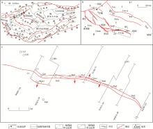
图1
巴楚隆起玛扎塔格断裂带分布特征及剖面位置 a.塔里木盆地构造单元划分;b.巴楚隆起断裂展布;c.玛扎塔格断列带展布Ⅰ.阿瓦提凹陷;Ⅱ.巴楚隆起;Ⅲ.麦盖提斜坡;Ⅳ.柯坪断隆; Faq.阿恰断裂;Ftmxk.吐木休克断裂;Fklsy.卡拉沙依断裂;Fgds.古董山断裂;Fmztg.玛扎塔格断裂;Fhmls.海米罗斯断裂带;Fslby.色力布亚断裂带;Fbd.巴东断裂"
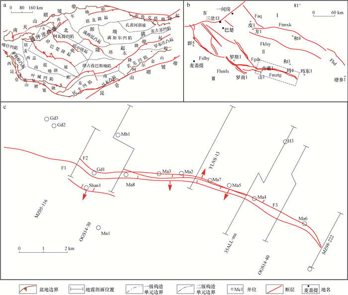
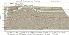
图2
玛扎塔格断裂带MZ05-116地震剖面(剖面位置见图 1)"
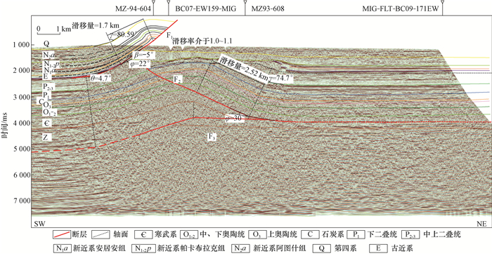

图3
玛扎塔格断裂带OGSZ14-30地震解释剖面(剖面位置见图 1)"

图4
玛扎塔格断裂带YL-NS13地震剖面(剖面位置见图 1)"
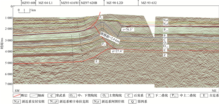
图5
玛扎塔格断裂带35ALL-ma地震剖面(剖面位置见图 1)"

图6
玛扎塔格断裂带OGS14-40地震剖面(剖面位置见图 1)"

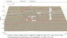
图7
玛扎塔格断裂带MZ98-222地震剖面(剖面位置见图 1)"
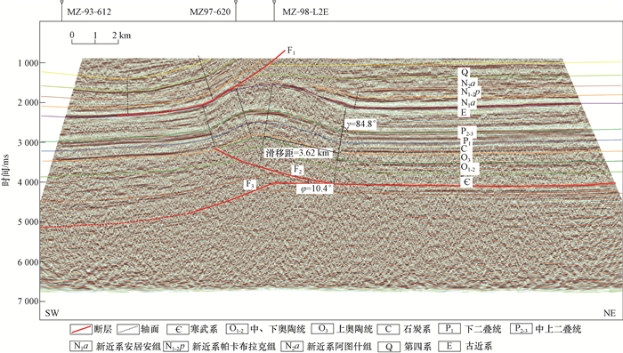
表1
玛扎塔格断裂带各剖面断层定量几何学特征统计(剖面位置见图 1)"
| 编号 | 剖面名称 | 构造分层 | 转折前上盘 截层角/(°) | 向斜翼间角 半角/(°) | 断层转折角/ (°) | 转折后上盘 截层角/(°) | 新生界断层 滑移量/km |
| 1 | MZ05-116 | 新生界 | 4.7 | 80.59 | 22 | -5 | 1.70 |
| 古生界 | 0 | 74.70 | 30 | 0 | 2.52 | ||
| 2 | OGS14-30 | 新生界 | — | — | — | — | — |
| 古生界 | 0 | 72.56 | 35 | 0 | 3.14 | ||
| 3 | HT96-148 | 新生界 | — | — | — | — | — |
| 古生界 | 0 | 75.50 | 29 | 0 | 2.86 | ||
| 4 | 35ALL-ma | 新生界 | 12.5 | 80.00 | 18 | -12 | 2.61 |
| 古生界 | 0 | 82.10 | 18 | 0 | 5.38 | ||
| 5 | OGS14-40 | 新生界 | 16.0 | 86.00 | 10 | -15 | 2.15 |
| 古生界 | — | — | — | — | — | ||
| 6 | MZ98-222 | 新生界 | — | — | — | — | — |
| 古生界 | 0 | 84.80 | 10.4 | 0 | 3.62 |

图8
玛扎塔格断裂带断层三维形态 a.新生界断层及古近系底面;b.新生界断层及鸟山断裂新生界断层; c.古生界断层及寒武系底、基底; d.基底断层及古生界断层"
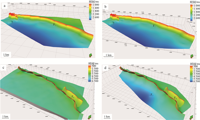
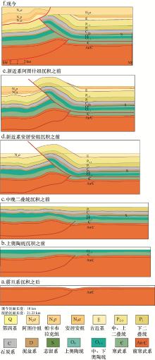
图9
过玛扎塔格断裂带OGS14-40剖面演化过程"

图10
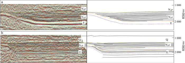
扎塔格断裂带北侧地层接触关系特征(剖面位置见图 1) a.剖面MZ98-222;b.剖面MZ98214"
| 1 |
周新源, 杨海军, 李勇, 等. 中国海相油气田勘探实例之七: 塔里木盆地和田河气田的勘探与发现[J]. 海相油气地质, 2006, 11 (3): 55- 62.
doi: 10.3969/j.issn.1672-9854.2006.03.009 |
|
Zhou Xinyuan , Yang Haijun , Li Yong , et al. Cases of discovery and exploration of marine fields in China(part7): Hotanhe gas field in Tarim Basin[J]. Marine Origin Petreleum Geology, 2006, 11 (3): 55- 62.
doi: 10.3969/j.issn.1672-9854.2006.03.009 |
|
| 2 |
肖安成, 杨树峰, 李曰俊, 等. 塔里木盆地巴楚-柯坪地区新生代断裂系统[J]. 石油与天然气地质, 2005, 26 (1): 78- 86.
doi: 10.3321/j.issn:0253-9985.2005.01.011 |
|
Xiao Ancheng , Yang Shufeng , Li Yuejun , et al. A studying of Cenozoic fracture systems in Bachu-Kalpin area, Tarim Basin[J]. Oil & Gas Geology, 2005, 26 (1): 78- 86.
doi: 10.3321/j.issn:0253-9985.2005.01.011 |
|
| 3 |
杨海军, 李曰俊, 冯晓军, 等. 塔里木盆地玛扎塔格构造带断裂构造分析[J]. 地质科学, 2007, 42 (3): 506- 517.
doi: 10.3321/j.issn:0563-5020.2007.03.008 |
|
Yang Haijun , Li Yuejun , Feng Xiaojun , et al. Analysis on thrustings of the Mazhatage structural belt in The Tarim Basin[J]. Chinese Journal of Geology, 2007, 42 (3): 506- 517.
doi: 10.3321/j.issn:0563-5020.2007.03.008 |
|
| 4 | 吕海涛, 张仲培, 邵志兵, 等. 塔里木盆地巴楚-麦盖提地区早古生代古隆起的演化及其勘探意义[J]. 石油与天然气地质, 2010, 31 (1): 76- 82. |
| Lv Haitao , Zhang Zhongpei , Shao Zhibing , et al. Structural evolution and exploration significance of the early Paleozoic palaeouplifts in Bachu-Maigaiti area, the Tarim Basin[J]. Oil & Gas Geology, 2010, 31 (1): 76- 82. | |
| 5 | 何娟, 王毅, 刘士林, 等. 塔里木盆地西南坳陷东部构造特征及对油气成藏的控制[J]. 石油实验地质, 2016, 38 (3): 326- 332. |
| He Juan , Wang Yi , Liu Shilin , et al. Characteristics of fault structure and its control on hydrocarbon accumulation in the eastern part of southwestern Tarim Basin[J]. Petroleum Geology & Experiment, 2016, 38 (3): 326- 332. | |
| 6 | 张强, 黄太柱, 李慧莉, 等. 塔里木盆地西部的新生代断裂活动[J]. 岩石学报, 2016, 32 (3): 833- 846. |
| Zhang Qiang , Huang Taizhu , Li Huili , et al. The Cenozoic faults in western Tarim Basin, NW China[J]. Acta Petrologica Sinica, 2016, 32 (3): 833- 846. | |
| 7 | 胡望水, 陈毓遂, 肖安成, 等. 塔里木色力布亚-玛扎塔格断裂系与油气[J]. 新疆地质, 1996, 14 (1): 61- 68. |
| Hu Wangshui , Chen Yusui , Xiao Ancheng , et al. Deformation of Serikbuya-Mazartag fault system in Tarim and its relation with oil-gas[J]. XinJiang Geology, 1996, 14 (1): 61- 68. | |
| 8 |
郭颖, 汤良杰, 余腾孝, 等. 塔里木盆地玛扎塔格断裂带构造特征及其油气地质意义[J]. 地球科学与环境学报, 2016, 38 (1): 104- 114.
doi: 10.3969/j.issn.1672-6561.2016.01.010 |
|
Guo Ying , Tang Liangjie , Yu Tengxiao , et al. Structural characteristics and petroleum geological significances of Mazhatage fault belt in Tarim Basin[J]. Journal of Earth Sciences and Environment, 2016, 38 (1): 104- 114.
doi: 10.3969/j.issn.1672-6561.2016.01.010 |
|
| 9 | 王毅, 张仲培, 张波, 等. 塔里盆地巴楚地区大型膝褶带的发现及油气勘探意义[J]. 石油与天然气地质, 2014, 35 (6): 914- 924. |
| Wang Yi , Zhang Zhongpei , Zhang Bo , et al. Discovery of large kink-band structures and petroleum exploration implications in Bachu area, Tarim Basin[J]. Oil & Gas Geology, 2014, 35 (6): 914- 924. | |
| 10 |
杨庚. 塔里木盆地玛扎塔格弧形构造及斜向逆冲[J]. 地球科学与环境学报, 2018, 40 (4): 381- 397.
doi: 10.3969/j.issn.1672-6561.2018.04.003 |
|
Yang Geng . Mazatage arcuate structure in map-view and oblique thrust in Tarim Basin, Western China[J]. Journal of Earth Sciences and Environment, 2018, 40 (4): 381- 397.
doi: 10.3969/j.issn.1672-6561.2018.04.003 |
|
| 11 |
李洪辉, 邬光辉, 王洪江, 等. 塔里木盆地和田河气田周缘构造演化、成藏与勘探领域[J]. 现代地质, 2009, 23 (4): 587- 594.
doi: 10.3969/j.issn.1000-8527.2009.04.002 |
|
Li Honghui , Wu Guanghui , Wang Hongjiang , et al. Structural evolution, reservoir forming and exploration field of peripheral area of the Hetianhe gas field in Tarim Basin[J]. Geoscience, 2009, 23 (4): 587- 594.
doi: 10.3969/j.issn.1000-8527.2009.04.002 |
|
| 12 |
张洪安, 吴根耀, 李曰俊, 等. 塔里木盆地西部巴楚断隆南界断裂带的主要特征和构造演化[J]. 地质通报, 2011, 30 (10): 1547- 1556.
doi: 10.3969/j.issn.1671-2552.2011.10.008 |
|
Zhang Hongan , Wu Genyao , Li Yuejun , et al. Main features and structural evolution of southern boundary fractural zone of the Bachu fault-rise in western Tarim Basin[J]. Geological Bulletin of China, 2011, 30 (10): 1547- 1556.
doi: 10.3969/j.issn.1671-2552.2011.10.008 |
|
| 13 | 杨庚, 李伟, 陈竹新, 等. 塔里木盆地和田河气田玛扎塔格滑脱背斜构造特征[J]. 石油与天然气地质, 2015, 36 (4): 563- 572. |
| Yang Geng , Li Wei , Chen Zhuxin , et al. Mazatage detachment anticline in Hetianhe gas field, Tarim Basin, western China[J]. Oil & Gas Geology, 2015, 36 (4): 563- 572. | |
| 14 | 崔海峰, 田雷, 刘军, 等. 麦盖提斜坡东段断裂活动特征及油气意义[J]. 石油地球物理勘探, 2016, 51 (6): 1241- 1250. |
| Cui Haifeng , Tian Lei , Liu Jun , et al. Fault activity characteristics in Maigaiti eastern slope and its hydrocarbon significance[J]. Oil Geophysical Prospecting, 2016, 51 (6): 1241- 1250. | |
| 15 | 谢会文, 陈新伟, 朱民, 等. 塔里木盆地玛扎塔格断裂带变形特征、演化及对深层油气成藏的控制[J]. 地球科学, 2017, 42 (9): 1578- 1589. |
| Xie Huiwen , Chen Xinwei , Zhu Min , et al. Deformation characteristics, tectonic evolution and their control on deep petroleum accumulation of Mazhatage fault belt in Tarim Basin[J]. Earth Science, 2017, 42 (9): 1578- 1589. | |
| 16 |
李钦, 刘健. 塔里木盆地腹地玛扎塔格地区新近纪砂岩组分和重矿物组合特征及物源分析[J]. 地质力学学报, 2017, 23 (4): 306- 314.
doi: 10.3969/j.issn.1006-6616.2017.02.014 |
|
Li Qin , Liu Jian . Analysis of detrital composition, heavy mineral combination characteristics and sand provenance of Neogene sandstones, Mazhatage Moutain in the center of Tarim Basin[J]. Journal of Geomechanics, 2017, 23 (2): 306- 314.
doi: 10.3969/j.issn.1006-6616.2017.02.014 |
|
| 17 | 贾承造. 中国塔里木盆地构造特征与油气[M]. 北京: 石油工业出版社, 1997: 370 |
| Jia Chengzao . Tectomc elements and stratigraphy of Tarim Basin, NW China[M]. Beijing: Petroleum Industry Press, 1997: 370 | |
| 18 |
Suppe J . Geometry and kinematics of fault-bend folding[J]. American Journal of Science, 1983, 283, 684- 721.
doi: 10.2475/ajs.283.7.684 |
| 19 | 何碧竹, 焦存礼, 黄太柱, 等. 塔里木盆地新元古代裂陷群结构构造及其形成动力学[J]. 中国科学: 地球科学, 2019, 49 (4): 635- 655. |
| He Bizhu , Jiao Cunli , Huang Taizhu , et al. Structural architecture of Neoproterozoic rifting depression groups in the Tarim Basin and their formation dynamics[J]. Science China Earth Sciences, 2019, 49 (4): 635- 655. | |
| 20 |
姜海健, 陈强路, 杨鑫, 等. 塔里木盆地新元古代裂谷盆地层序样式[J]. 地质学报, 2017, 91 (3): 588- 604.
doi: 10.3969/j.issn.0001-5717.2017.03.007 |
|
Jiang HaiJian , Chen Qianglu , Yang xing , et al. The style of sequence stratigraphy of Neoproterozoic rift Basin in the Tarim Basin[J]. Acta Geologica Sinica, 2017, 91 (3): 588- 604.
doi: 10.3969/j.issn.0001-5717.2017.03.007 |
|
| 21 |
杨鑫, 李慧莉, 张仲培, 等. 塔里木新元古代盆地演化与下寒武统烃源岩发育的构造背景[J]. 地质学报, 2017, 91 (8): 1706- 1719.
doi: 10.3969/j.issn.0001-5717.2017.08.004 |
|
Yang Xin , Li Huili , Zhang Zhongpei , et al. Evolution of Neoproterozoic Tarim Basin in Northwestern China and tectonic background of the lower Cambrian hydrocarbon source rocks[J]. Acta Geologica Sinica, 2017, 91 (8): 1706- 1719.
doi: 10.3969/j.issn.0001-5717.2017.08.004 |
|
| 22 | 张永, 何登发, 刘长磊, 等. 塔里木盆地巴楚隆起的三维地质结构及成因机制[J]. 地学前缘, 2019, 26 (1): 134- 148. |
| Zhang yong , He Dengfa , Liu Changlei . Three-dimensional geological structure and genetic mechanism of the Bachu uplift in the Tarim Basin[J]. Earth Science Frontiers, 2019, 26 (1): 134- 148. | |
| 23 | 郑孟林, 王毅, 金之钧, 等. 塔里木盆地叠合演化与油气聚集[J]. 石油与天然气地质, 2014, 35 (6): 925- 934. |
| Zheng Menglin , Wang Yi , Jin Zhijun , et al. Superimposition, evolution and petroleum accumulation of Tarim Basin[J]. Oil & Gas Geology, 2014, 35 (6): 925- 934. | |
| 24 |
何登发. 塔里木盆地的地层不整合面与油气聚集[J]. 石油学报, 1995, 16 (3): 14- 21.
doi: 10.3321/j.issn:0253-2697.1995.03.019 |
|
He Dengfa . Unconformities and oil and gas accumulation in Tarim Basin[J]. Acta Petrolei Sinica, 1995, 16 (3): 14- 21.
doi: 10.3321/j.issn:0253-2697.1995.03.019 |
|
| 25 |
何登发, 贾承造, 李德生, 等. 塔里木多旋回叠合盆地的形成与演化[J]. 石油与天然气地质, 2005, 26 (1): 64- 77.
doi: 10.3321/j.issn:0253-9985.2005.01.010 |
|
He Dengfa , Jia Chengzao , Li Desheng , et al. Formation and evolution of polycyclic superimposed Tarim Basin[J]. Oil & Gas Geology, 2005, 26 (1): 64- 77.
doi: 10.3321/j.issn:0253-9985.2005.01.010 |
|
| 26 |
丁文龙, 林畅松, 漆立新, 等. 塔里木盆地巴楚隆起构造格架及形成演化[J]. 地学前缘, 2008, 15 (2): 242- 252.
doi: 10.3321/j.issn:1005-2321.2008.02.027 |
|
Ding Wenlong , Lin Changsong , Qi Lixin , et al. Structural framework and evolution of Bachu uplift in Tarim basin[J]. Earth Science Frontiers, 2008, 15 (2): 242- 252.
doi: 10.3321/j.issn:1005-2321.2008.02.027 |
|
| 27 | 任建业, 张俊霞, 阳怀忠, 等. 塔里木盆地中央隆起带断裂系统分析[J]. 岩石学报, 2011, 27 (1): 219- 230. |
| Ren Jianye , Zhang Junxia , Yang Huaizhong , et al. Analysis of fault systems in the Central uplift, Tarim Basin[J]. Acta Petrologica Sinica, 2011, 27 (1): 219- 230. | |
| 28 | 任建业, 阳怀忠, 胡德胜, 等. 塔里木盆地中央隆起带断裂活动及其对海相克拉通解体的作用[J]. 地球科学-中国地质大学学报, 2012, 37 (4): 645- 653. |
| Ren Jianye , Yang Huaizhong , Hu Desheng , et al. Fault activity and its controlling to marine cratonic breakup in Tarim Basin[J]. Earth Science-Journal of China University of Geosciences, 2012, 37 (4): 645- 653. | |
| 29 | 邹亚锐, 塔吉古丽, 邢作云, 等. 塔里木新元古代-古生代沉积盆地演化[J]. 地球科学-中国地质大学学报, 2014, 39 (8): 1200- 1216. |
| Zou Yarui , Ta Jiguli , Xing Zuoyun , et al. Evolution of sedimentary basins in Tarim during Neoproterozoic-Paleozoic[J]. Earth Science-Journal of China University of Geosciences, 2014, 39 (8): 1200- 1216. | |
| 30 | 张克信, 王国灿, 季军良, 等. 青藏高原古近纪-新近纪地层分区与序列及其对隆升的响应[J]. 中国科学: 地球科学, 2010, 40 (12): 1632- 1654. |
| Zhang Kexin , Wang Guocan , Ji Junliang , et al. Paleogene-Neogene stratigraphic realm and sedimentary sequence of the Qinghai-Tibet Plateau and their response to uplift of the plateau[J]. Science China Earth Science, 2010, 40 (12): 1632- 1654. | |
| 31 |
AD Gibbons , S Zahirovic , RD Müller , et al. A tectonic model reconciling evidence for the collisions between India, Eurasia and intra-oceanic arcs of the central-eastern Tethys[J]. Gondwana Research, 2015, 28 (2): 451- 492.
doi: 10.1016/j.gr.2015.01.001 |
| 32 |
肖安成, 杨树锋, 李曰俊, 等. 塔里木盆地巴楚隆起断裂系统主要形成时代的新认识[J]. 地质科学, 2005, 40 (2): 291- 302.
doi: 10.3321/j.issn:0563-5020.2005.02.013 |
|
Xiao Ancheng , Yang Shufeng , Li Yuejun , et al. Main period for creation of fracture system in the Bachu uplift, Tarim Basin[J]. Chinese Journal of Geology, 2005, 40 (2): 291- 302.
doi: 10.3321/j.issn:0563-5020.2005.02.013 |
|
| 33 | 李文山, 李江海, 周肖贝, 等. 塔里木盆地中央高磁异常带成因: 来自地震反射剖面的新证据[J]. 北京大学学报(自然科学版), 2014, 50 (2): 281- 287. |
| Li Wenshan , Li Jianghai , Zhou Xiaobei , et al. Genesis of high aeromagnetic anomaly zone in Central Tarim Basin: new evidence from seismic Profiles[J]. Acta Scientiarum Naturalium Universitatis Pekinensis, 2014, 50 (2): 281- 287. | |
| 34 |
杨文采, 王家林, 钟慧智, 等. 塔里木盆地航磁场分析与磁源体结构[J]. 地球物理学报, 2012, 55 (4): 1278- 1287.
doi: 10.6038/j.issn.0001-5733.2012.04.023 |
|
Yang Wencai , Wang Jialin , Zhong Huizhi , et al. Analysis of regional magnetic field and source structure in Tarim Basin[J]. Chinese Journal of Geophysics, 2012, 55 (4): 1278- 1287.
doi: 10.6038/j.issn.0001-5733.2012.04.023 |
|
| 35 |
刘因, 付建民, 姜枚, 等. 接收函数方法获得的和田-拜城剖面壳幔图像[J]. 中国地质, 2011, 38 (4): 1066- 1070.
doi: 10.3969/j.issn.1000-3657.2011.04.024 |
|
Liu Yin , Fu Jianmin , Jiang Mei , et al. The image of the crust and upper mantle along the Hotan-Baicheng section using the receiver function method[J]. Geology in China, 2011, 38 (4): 1066- 1070.
doi: 10.3969/j.issn.1000-3657.2011.04.024 |
|
| 36 | 杨庚兄, 尹宏伟, 汪伟, 等. 塔里木盆地玛扎塔格构造带深层构造分析[J]. 大地构造与成矿学, 2020, 44 (5): 819- 830. |
| Yang Gengxiong , Yin Hongwei , Wang Wei , et al. Deep structural analysis of Mazatag tectonic belt in Tarim Basin[J]. Geotectonica et Metallogenia, 2020, 44 (5): 819- 830. | |
| 37 | 邓尚, 李慧莉, 张仲培, 等. 塔里木盆地顺北及邻区主干走滑断裂带差异活动特征及其与油气富集的关系[J]. 石油与天然气地质, 2018, 39 (5): 878- 888. |
| Deng Shang , Li Huili , Zhang Zhongpei , et al. Characteristics of differential activities in major strike-slip fault zones and their control on hydrocarbon enrichment in Shunbei area and its surroundings, Tarim Basin[J]. Oil & Gas Geology, 2018, 39 (5): 878- 888. | |
| 38 | 曹自成, 路清华, 顾忆, 等. 塔里木盆地顺北油气田1号和5号断裂带奥陶系油气藏特征[J]. 石油与天然气地质, 2020, 41 (5): 975- 984. |
| Cao Zicheng , Lu Qinghua , Gu Yi , et al. Characteristics of Ordovician reservoirs in Shunbei 1 and 5 fault zones, Tarim Basin[J]. Oil & Gas Geology, 2020, 41 (5): 975- 984. | |
| 39 | 王斌, 赵永强, 何生, 等. 塔里木盆地顺北5号断裂带北段奥陶系油气成藏期次及其控制因素[J]. 石油与天然气地质, 2020, 41 (5): 965- 974. |
| Wang Bin , Zhao Yongqiang , He Sheng , et al. Hydrocarbon accumulation stages and their controlling factors in the northern Ordovician Shunbei 5 fault zone, Tarim Basin[J]. Oil & Gas Geology, 2020, 41 (5): 965- 974. | |
| 40 | 王玉伟, 陈红汉, 郭会芳, 等. 塔里木盆地顺1走滑断裂带超深储层油气充注历史[J]. 石油与天然气地质, 2019, 40 (5): 972- 989. |
| Wang Yuwei , Chen Honghan , Guo Huifang , et al. Hydrocarbon charging history of the ultra-deep reservoir in Shun 1 strike-slip fault zone, Tarim Basin[J]. Oil & Gas Geology, 2019, 40 (5): 972- 989. | |
| 41 | 韩勇, 徐浩. 塔河油田于奇地区断裂体系特征研究[J]. 石油地质与工程, 2020, 34 (3): 7- 12. |
| Han Yong , Xu Hao . Characteristics of fault system in Yuqi area of Tahe oilfield[J]. Petroleum Geology & Engineering, 2020, 34 (3): 7- 12. | |
| 42 | 张秋实. 惠民凹陷扭张断裂与沉积耦合关系的量化表征[J]. 断块油气田, 2020, 27 (5): 556- 560. |
| Zhang Qiushi . Quantitative characterization of the coupling relationship between transtensional faults and sedimentation in Huimin Sag[J]. Fault-Block Oil and Gas Field, 2020, 27 (5): 556- 560. | |
| 43 | 张伟忠, 张云银, 查明, 等. 渤海湾盆地东营凹陷扭张断裂成因模式及控藏作用[J]. 石油与天然气地质, 2019, 40 (2): 262- 270. |
| Zhang Weizhong , Zhang Yunyin , Zha Ming , et al. Genetic model of transtensional faults in Dongying Depression, Bohai Bay Basin, and its controls over hydrocarbon accumulation[J]. Oil & Gas Geology, 2019, 40 (2): 262- 270. | |
| 44 | 张波, 李生福, 张进江, 等. 膝褶、膝褶带、共轭膝褶带-一种可能的新型油气构造样式[J]. 天然气工业, 2010, 30 (2): 32- 39. |
| Zhang Bo , Li Shengfu , Zhang Jinjiang , et al. Kink, kink-band and conjugate kink-band: A probably potential new type of structural trap[J]. Natural Gas Industry, 2010, 30 (2): 32- 39. | |
| 45 |
Verbeel E R . Kink bands in the Somport slates, west-central Pyrenees, France and Spain[J]. Geological Society of America Bulletin, 1978, 89, 814- 824.
doi: 10.1130/0016-7606(1978)89<814:KBITSS>2.0.CO;2 |
| 46 | 王招明, 王清华, 赵孟军, 等. 塔里木盆地和田河气田天然气地球化学特征及成藏过程[J]. 中国科学: D辑, 地球科学, 2007, 37 (增2): 69- 79. |
| Wang Zhaoming , Wang Qinghua , Zhao Mengjun , et al. Natural gas geochemical characteristics and accumulation process of Hetianhe gas field, Tarim Basin[J]. Science in China: Series D, Earth Sciences, 2007, 37 (S2): 69- 79. |
| [1] | 韩鹏远, 丁文龙, 杨德彬, 张娟, 马海陇, 王生晖. 塔里木盆地塔河油田S80走滑断裂发育特征及其对奥陶系储层的控制作用[J]. 石油与天然气地质, 2024, 45(3): 770-786. |
| [2] | 张艳秋, 陈红汉, 王燮培, 王彭, 苏丹梅, 谢舟. 塔里木盆地富满油田走滑断裂带通源性评价[J]. 石油与天然气地质, 2024, 45(3): 787-800. |
| [3] | 丁文龙, 李云涛, 韩俊, 黄诚, 王来源, 孟庆修. 碳酸盐岩储层高精度构造应力场模拟与裂缝多参数分布预测方法及其应用[J]. 石油与天然气地质, 2024, 45(3): 827-851. |
| [4] | 曹自成, 云露, 漆立新, 李海英, 韩俊, 耿锋, 林波, 陈菁萍, 黄诚, 毛庆言. 塔里木盆地顺北地区顺北84X井超千米含油气重大发现及其意义[J]. 石油与天然气地质, 2024, 45(2): 341-356. |
| [5] | 杨德彬, 鲁新便, 鲍典, 曹飞, 汪彦, 王明, 谢润成. 塔里木盆地北部奥陶系海相碳酸盐岩断溶体油藏成因类型及特征再认识[J]. 石油与天然气地质, 2024, 45(2): 357-366. |
| [6] | 张长建, 杨德彬, 蒋林, 姜应兵, 昌琪, 马雪健. 塔里木盆地塔河北部“过溶蚀残留型”断溶体发育特征及其成因[J]. 石油与天然气地质, 2024, 45(2): 367-383. |
| [7] | 江同文, 邓兴梁, 曹鹏, 常少英. 塔里木盆地富满断控破碎体油藏储集类型特征与注水替油效果[J]. 石油与天然气地质, 2024, 45(2): 542-552. |
| [8] | 牛月萌, 韩俊, 余一欣, 黄诚, 林波, 杨帆, 余浪, 陈俊宇. 塔里木盆地顺北西部地区火成岩侵入体发育特征及其与断裂耦合关系[J]. 石油与天然气地质, 2024, 45(1): 231-242. |
| [9] | 张三, 金强, 史今雄, 胡明毅, 段梦悦, 李永强, 张旭栋, 程付启. 塔北地区奥陶系地下河溶洞充填规律与储集性能[J]. 石油与天然气地质, 2023, 44(6): 1582-1594. |
| [10] | 康志江, 张冬梅, 张振坤, 王睿奇, 姜文斌, 刘坤岩. 深层缝洞型油藏井间连通路径智能预测技术[J]. 石油与天然气地质, 2023, 44(5): 1290-1299. |
| [11] | 胡伟, 徐婷, 杨阳, 伦增珉, 李宗宇, 康志江, 赵瑞明, 梅胜文. 塔里木盆地超深油气藏流体相行为变化特征[J]. 石油与天然气地质, 2023, 44(4): 1044-1053. |
| [12] | 张坦, 姚威, 赵永强, 周雨双, 黄继文, 范昕禹, 罗宇. 塔里木盆地巴麦地区石炭系卡拉沙依组年代标尺及地层剥蚀厚度精细计算[J]. 石油与天然气地质, 2023, 44(4): 1054-1066. |
| [13] | 郭宏辉, 冯建伟, 赵力彬. 塔里木盆地博孜—大北地区被动走滑构造特征及其对裂缝发育的控制作用[J]. 石油与天然气地质, 2023, 44(4): 962-975. |
| [14] | 李斌, 赵星星, 邬光辉, 韩剑发, 关宝珠, 沈春光. 塔里木盆地塔中Ⅱ区奥陶系油气差异富集模式[J]. 石油与天然气地质, 2023, 44(2): 308-320. |
| [15] | 张红波, 周雨双, 沙旭光, 邓尚, 沈向存, 姜忠正. 塔里木盆地顺北5号走滑断裂隆起段发育特征与演化机制[J]. 石油与天然气地质, 2023, 44(2): 321-334. |
| 阅读次数 | ||||||||||||||||||||||||||||||||||||||||||||||||||
|
全文 119
|
|
|||||||||||||||||||||||||||||||||||||||||||||||||
|
摘要 322
|
|
|||||||||||||||||||||||||||||||||||||||||||||||||