

石油与天然气地质 ›› 2022, Vol. 43 ›› Issue (1): 207-218.doi: 10.11743/ogg20220117
张文彪1( ), 张亚雄1, 段太忠1, 李蒙1, 赵华伟1, 汪彦2
收稿日期:2020-06-12
修回日期:2021-12-06
出版日期:2022-02-01
发布日期:2022-01-28
第一作者简介:张文彪(1984—),男,高级工程师,油气田开发地质及三维地质建模。E?mail:基金项目:
Wenbiao Zhang1(), Yaxiong Zhang1, Taizhong Duan1, Meng Li1, Huawei Zhao1, Yan Wang2
Received:2020-06-12
Revised:2021-12-06
Online:2022-02-01
Published:2022-01-28
摘要:
断控岩溶储集体(断溶体)作为缝洞型碳酸盐岩储层的一种特殊类型,受大型走滑断裂带影响,其空间结构复杂、形态不规则且随机性强,给三维精细描述及地质建模带来新的挑战。基于多元、多尺度研究资料,对塔里木盆地塔河油田断溶体系结构层次进行了划分,并提出了断溶体系 “层次约束、成因控制、逐级建模”的建模思路。结果表明:断溶体系按照形成过程及尺度规模划分为走滑断裂破碎带、断溶体、断溶体内部缝洞带、溶洞充填4个层次。以地震精细相干解释得到的主干断裂、次级断裂、包络范围及关键层位为确定性数据,建立走滑断裂破碎带格架模型。基于地震FL(fault likelihood)属性,通过属性自动分割及钻井标定,采用确定性方法建立断溶体轮廓模型。在断溶体轮廓的约束下,对内部缝洞带各要素采用分类建模方法,基于地震Texture属性及蚂蚁体属性截断,人机交互,采用确定性方法分别建立大型溶洞模型及中尺度裂缝离散分布模型;基于井点条件数据控制及地质-地震综合概率体约束,采用序贯指示模拟和示性点过程模拟方法,分别得到溶蚀孔洞分布模型及小尺度裂缝离散分布模型;基于波阻抗与大型洞穴约束,采用序贯指示模拟方法建立洞穴内部岩性充填模型。以塔里木盆地塔河油田托甫台区典型断溶体单元为例,建立的断溶体系三维模型体现了空间层次结构特征。
中图分类号:
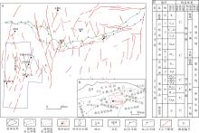
图1
塔河油田构造位置及地层综合柱状图a.塔河油田构造位置;b.塔里木盆地构造分布;c.塔河油田地层综合柱状图"

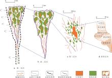
图2
断溶体系结构层次划分a.走滑断裂破碎带;b.断溶体;c.断溶体内部缝洞带;d.洞穴充填T74.一间房组顶;T76.鹰山组下段顶;T78.蓬莱坝组顶;T80.寒武系顶;T90.寒武系底"

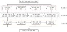
图3
断溶体系层次建模流程"

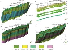
图4
塔河油田托甫台地区TP12CX断裂带典型单元走滑断裂破碎带模型a.主干分支断裂及包络带范围解释;b.主要研究层位;c.地层模型;d.破碎带整体模型T74.一间房组顶;T75.鹰山组上段顶;T76.鹰山组下段顶;T78.蓬莱坝组顶;T80.寒武系顶;T81.上寒武统底"

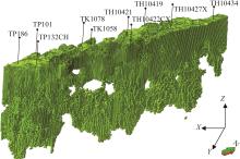
图5
塔河油田托甫台地区TP12CX断裂带典型单元断溶体模型"

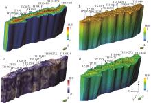
图6
塔河油田托甫台地区TP12CX断裂带典型单元缝洞带建模概率体模型a.断裂主控横向地质概率体模型;b.断裂主控纵向地质概率体模型;c.地震概率体模型;d.基于线性加权的地质-地震综合概率体模型"

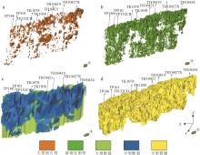
图7
塔河油田托甫台地区TP12CX断裂带典型单元多维、多尺度缝洞带建模结果a.大型洞穴带三维模型;b.溶蚀孔洞带三维模型;c.大、中型裂缝片模型;d.小型裂缝片模型"

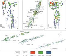
图8
塔河油田托甫台地区TP12CX断裂带典型单元断溶体内部缝洞带建模结果a.过TP101井模型剖面结果;b.溶蚀孔洞带平面分布结果;c.过TH10421井模型剖面结果;d.缝洞带发育演化规律"

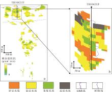
图9
塔河油田托甫台地区TP12CX断裂带典型单元断溶体洞穴充填结构模型a.剩余波阻抗模型;b.洞穴内部可能充填结构"
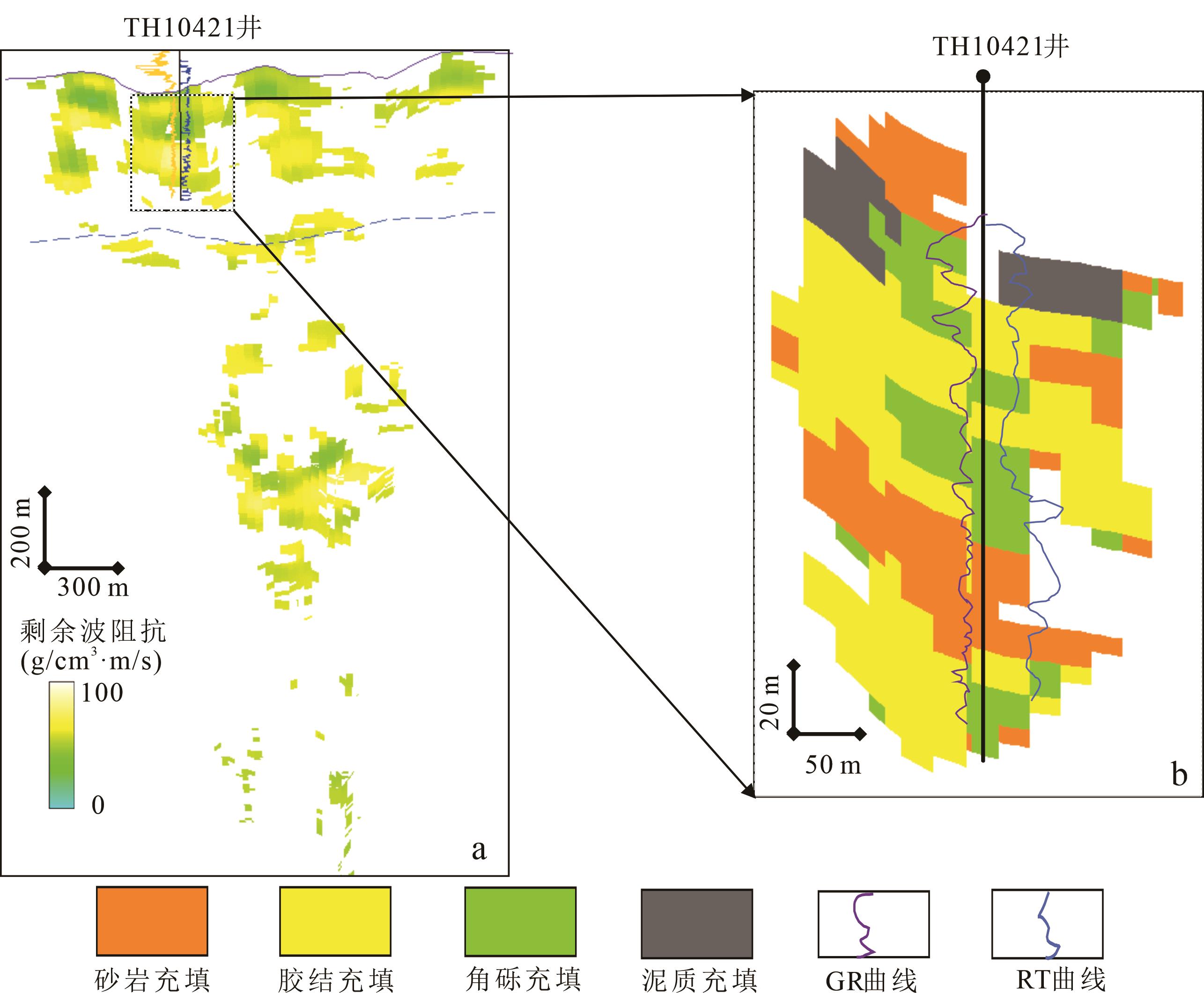
图10
塔河油田托甫台地区TP12CX断裂带典型单元断溶体系多重离散介质综合模型"
| 1 | 侯加根, 马晓强, 刘钰铭, 等. 缝洞型碳酸盐岩储层多类多尺度建模方法研究——以塔河油田四区奥陶系油藏为例[J]. 地学前缘,2012, 19(2): 59-66. |
| Hou Jiagen, Ma Xiaoqiang, Liu Yuming, et al. Modelling of carbonate fracture⁃vuggy reservoir: A case study of Ordovician reservoir of 4th block in Tahe Oilfield [J]. Earth Science Frontiers, 2012, 19(2): 59-66. | |
| 2 | 侯加根, 马晓强, 胡向阳, 等. 碳酸盐岩溶洞型储集体地质建模的几个关键问题[J]. 高校地质学报, 2013, 19(1): 64-69. |
| Hou Jiagen, Ma Xiaoqiang, Hu Xiangyang, et al. Key issues of 3D geological modeling of paleokarst⁃cave carbonate reservoir[J]. Geological Journal of China Universities, 2013, 19(1): 64-69 | |
| 3 | 马晓强, 侯加根, 胡向阳, 等. 论古岩溶洞穴型储层三维地质建模——以塔河油田四区奥陶系储层为例[J]. 地质论评, 2013, 59(2):315-324. |
| Ma Xiaoqiang, Hou Jiagen, Hu Xiangyang, et al. Discussion on 3D geological modeling of palaeokarst cave reservoir: A case study on ordovician reservoir of the 4th block in the Tahe Oilfield[J]. Geological Review, 2013, 59(2): 315-324. | |
| 4 | 康志江,李阳,计秉玉,等.碳酸盐岩缝洞型油藏提高采收率关键技术[J].石油与天然气地质,2020,41(2):434-441. |
| Kang Zhijiang, Li Yang, Ji Bingyu, et al. Key technologies for EOR in fractured⁃vuggy carbonate reservoirs[J]. Oil & Gas Geo⁃logy,2020,41(2):434-441. | |
| 5 | 胡向阳, 李阳, 权莲顺, 等. 碳酸盐岩缝洞型油藏三维地质建模方法——以塔河油田四区奥陶系油藏为例[J]. 石油与天然气地质, 2013, 34(3): 383-387. |
| Hu Xiangyang, Li Yang, Quan Lianshun, et al. Three⁃dimensional geological modeling of fractured⁃vuggy carbonate reservoirs: a case from the Ordovician reservoirs in Tahe⁃Ⅳblock,Tahe oilfield[J]. Oil &Gas Geology,2013,34(3): 383-387. | |
| 6 | 瞿长,赵锐,李慧莉,等.塔里木盆地顺北 5 断裂带储集体地震反射与产能特征分析[J].特种油气藏,2020,27(1):68-74. |
| Qu Chang, Zhao Rui, Li Huili, et al.Seismic reflection and productivity of reservoirs in the fault⁃zone 5 of Shunbei, Tarim Basin[J].Special Oil & Gas Reserviors, 2020, 27(1):68-74. | |
| 7 | 李阳, 侯加根, 李永强. 碳酸盐岩缝洞型储集体特征及分类分级地质建模[J]. 石油勘探与开发, 2016, 43(4): 600-606. |
| Li Yang, Hou Jiagen, Li Yongqiang. Features and classified hie⁃rarchical modeling of carbonate fracture⁃cavity reservoirs[J]. Petroleum Exploration and Development, 2016, 43(4): 600-606. | |
| 8 | 刘振峰,刘忠群,郭元岭,等.“断缝体”概念、地质模式及其在裂缝预测中的应用——以四川盆地川西坳陷新场地区须家河组二段致密砂岩气藏为例[J].石油与天然气地质,2021,42(4):973-980. |
| Liu Zhenfeng, Liu Zhongquan, Guo Yuanling,et al.Concept and geological model of fault⁃fracture reservoir and their application in seismic fracture prediction:A case study on the Xu 2 Member tight sandstone gas pool in Xinchang area,Western Sichuan Depression in Sichuan Basin[J].Oil & Gas Geology,2021,42(4):973-980.. | |
| 9 | 丁芳. 开发前期少井条件下低渗储层 “甜点”建模表征技术及其应用[J].大庆石油地质与开发,2020,39(6):135-142. |
| Ding Fang. Modeling and characterizing technique of the “sweet spot”and its application in low⁃permeability reservoirs with limited wells at the early stage of the development[J].Petroleum Geology & Oilfield Development in Daqing,2020,39(6):135-142. | |
| 10 | 吕心瑞,孙建芳,邬兴威,等.缝洞型碳酸盐岩油藏储层结构表征方法——以塔里木盆地塔河S67单元奥陶系油藏为例[J].石油与天然气地质,2021,42(3):728-737. |
| Xinrui Lyu, Sun Jianfang, Wu Xingwei,et al.Internal architecture characterization of fractured⁃vuggy carbonate reservoirs:A case study on the Ordovician reservoirs,Tahe Unit S67,Tarim Basin[J].Oil & Gas Geology,2021,42(3):728-737. | |
| 11 | 鲁新便, 赵敏, 胡向阳, 等.碳酸盐岩溶洞型油藏三维建模方法技术研究——以塔河奥陶系缝洞型油藏为例[J]. 石油实验地质, 2012, 34(2): 193-198. |
| Lu Xinbian, Zhao Min, Hu Xiangyang,et al .Studies of 3D reservoir modeling: taking Ordovician carbonate fractured⁃vuggy reservoirs in Tahe Oilfield as an example[J].Petroleum Geology & Experiment,2012,34( 2) : 193-198. | |
| 12 | 李永强,侯加根,刘钰铭,等. 基于岩溶模式的溶洞储集体三维地质建模[J]. 中国石油大学学报(自然科学版),2016,40( 5) : 43-50. |
| Li Yongqiang, Hou Jiagen, Liu Yuming, et al. 3D modeling of cave reservoirs based on karst patterns[J].Journal of China University of Petroleum(Edition of Natural Science), 2016, 40(5) : 43-50. | |
| 13 | 陈克勇,鲁洪江,何怡坤,等.以古溶洞主导的白云岩岩溶储渗体分布模式[J].断块油气田,2020,27(1):13-16. |
| Chen Keyong, Lu Hongjiang, He Yikun, et al. Distribution characteristics of dolomite reservoir⁃permeability systems determined⁃by epikarstic paleocaves[J].Fault⁃Block Oil and Gas Field,2020,27(1):13-16. | |
| 14 | 赵彬, 侯加根, 刘钰铭, 等. 塔河油田奥陶系碳酸盐岩溶洞型储层三维地质建模与应用[J].石油天然气学报, 2011, 33(5): 12-16. |
| Zhao Bin, Hou Jiagen, Liu Yuming, et al. Three dimensional modeling and application of Ordovician carbonate cavity reservoirs in Tahe Oilfield[J]. Journal of Oil and Gas Technology, 2011, 33(5): 12-16. | |
| 15 | 刘钰铭, 侯加根, 胡向阳, 等. 塔河油田古岩溶储集体三维建模[J]. 中国石油大学学报(自然科学版), 2012, 36(2): 34-38. |
| Liu Yuming, Hou Jiagen, Hu Xiangyang, et al. 3D modeling of paleokarst reservoir in Tahe Oilfield[J]. Journal of China University of Petroleum, 2012, 36(2): 34-38. | |
| 16 | 鲁新便,胡文革,汪彦,等 .塔河地区碳酸盐岩断溶体油藏特征与开发实践[J].石油与天然气地质,2015,36(3): 347-355. |
| Lu Xinbian, Hu Wenge, Wang Yan, et al. Characteristics and development practice of fault⁃karst carbonate reservoirs in Tahe area, Tarim Basin[J]. Oil & Gas Geology, 2015, 36(3): 347-355. | |
| 17 | 吴胜和, 李宇鹏. 储层地质建模的现状与展望[J]. 海相油气地质, 2007, 12(3): 53-60. |
| Wu Shenghe, Li Yupeng. Reservoir modeling: Current situation and developmental prospect[J]. Maine Oil and Gas Geology, 2007, 12(3): 53-60. | |
| 18 | 陈伟,吴智平,侯峰,等 .断裂带内部结构特征及其与油气运聚关系[J].石油学报,2010,31(5): 774-780. |
| Chen Wei, Wu Zhiping, Hou Feng,et al .Internal structures of fault zones and their relationship with hydrocarbon migration and accumulation [J]. Acta Petrolei Sinica,2010,31(5): 774-780. | |
| 19 | 陈秀艳,王剑,张立平,等.塔里木盆地哈拉哈塘地区石炭系东河砂岩段碳酸盐胶结物沉积特征及其成因[J].吉林大学学报(地球科学版),2020,50(2):509-517. |
| Chen Xiuyan, Wang Jian, Zhang Liping, et al. Sedimentary characteristics and genesis of carbonate cements in Carbonife⁃rous Donghe sandstone member, Hanilcatam area of Tarim Basin[J].Journal of Jilin University (Earth Science Edition),2020,50(2):509-517. | |
| 20 | 周文,李秀华,金文辉,等. 塔河奥陶系油藏断裂对古岩溶的控制作用[J].岩石学报,2011,27( 8) : 2339-2348. |
| Zhou Wen, Li Xiuhua, Jin Wenhui,et al .The control action of fault to paleokarst in view of Ordovician reservoirs in Tahe area[J].Acta Petrologica Sinica,2011,27( 8) : 2339-2348. | |
| 21 | 韩长城,林承焰,鲁新便,等 .塔河油田奥陶系碳酸盐岩岩溶斜坡断控岩溶储层特征及形成机制[J]. 石油与天然气地质,2016,37(5): 644-652. |
| Han Changcheng, Lin Chengyan, Lu Xinbian,et al. Characterization and genesis of fault⁃controlled karst reservoirs in Ordovician carbonate karst slope of Tahe oilfield,Tarim Basin[J]. Oil & Gas Geology,2016,37(5): 644- 652. | |
| 22 | Loucks R G. Paleocave carbonate reservoirs: Origins, burial⁃depth modifications, spatial complexity, and reservoir implications [J]. AAPG Bulletin, 1999, 83(3): 1795-1834. |
| 23 | 林煜,李相文,陈康,等.深层海相碳酸盐岩储层地震预测关键技术与效果——以四川盆地震旦系-寒武系与塔里木盆地奥陶系油气藏为例[J].石油与天然气地质,2021,42(3):717-727. |
| Lin Yu, Li Xiangwen, Chen Kang,et al.Key seismic techniques for predicting deep marine carbonate reservoirs and the effect analysis:A case study on the Sinian⁃Cambrian reservoirs in the Sichuan Basin and the Ordovician reservoirs in the Tarim Basin[J].Oil & Gas Geology,2021,42(3):717-727. | |
| 24 | 文欢, 邓光校, 王震. 塔河油田奥陶系油藏储集体发育控制因素分析-10区东高精三维区[J]. 非常规油气, 2017,4(1):37-42,74. |
| Wen Huan, Deng Guangxiao, Wang Zhen. Analysis of controlling factors of reservoir development in Ordovician reservoirs in Tahe Oilfield⁃3D high precision seismic Area in Eastern 10 Area[J].Unconventional Oil & Gas,2017,(1):37-42,74. | |
| 25 | 胡文革. 塔河碳酸盐岩缝洞型油藏开发技术及攻关方向[J]. 油气藏评价与开发, 2020, 10(2): 1-10. |
| Hu Wenge. Development technology and research direction of fractured⁃vuggy carbonate reservoirs in Tahe Oilfield[J]. Reservoir E⁃valuation and Development, 2020, 10(2): 1-10. | |
| 26 | 吴涛, 戴少康, 曹飞, 等. 走滑断裂系对碳酸盐岩“断溶体”油藏形成的控制作用[J]. 地球科学前沿, 2017, 7(5): 681-694. |
| Wu Tao, Dai Shaokang, Cao fei, et al. Strike⁃slip fault system and it’s controlling on the formation of “reservoir of fault controlling dissolution”: A case study of Toufutai area, Tahe oil fields [J]. Advances in Geosciences, 2017, 7(5): 681-694. | |
| 27 | 王震, 文欢, 邓光校, 等. 塔河油田碳酸盐岩断溶体刻画技术研究与应用[J]. 石油物探, 2019, 58(1):149-154. |
| Wang Zhen, Wen Huan, Deng Guangxiao, et al. Fault controlled⁃karst reservoir characterization technology in the Tahe Oilfield, China[J]. Geophysical Prospecting for Petroleum, 2019, 58(1):149-154. | |
| 28 | 温志新, 王红漫, 漆立新, 等. 塔河油田奥陶系缝洞型碳酸盐岩储层预测研究[J]. 地学前缘, 2008, 15(1): 94-100. |
| Wen Zhixin, Wang Hongman, Qi Lixin, et al. Research on the prediction of Ordovician carbonate reservoir of fissure⁃ cave type in the Tahe Oilfield[J]. Earth Science Frontiers,2008, 15(1):94-100. | |
| 29 | 王威,凡睿,黎承银,等.川东北地区须家河组“断缝体”气藏有利勘探目标和预测技术[J].石油与天然气地质,2021,42(4):992-1001. |
| Wang Wei, Fan Rui, Li Chengyin, et al. Exploration and prediction of promising fault⁃fracture reservoirs in the Xujiahe Formation, northeastern Sichuan Basin[J].Oil & Gas Geology,2021,42(4):992-1001. | |
| 30 | 马德波, 赵一民, 张银涛, 等. 最大似然属性在断裂识别中的应用-以塔里木盆地哈拉哈塘地区热瓦普区块奥陶系走滑断裂的识别为例[J]. 天然气地球科学, 2018, 29(6): 817-825. |
| Ma Debo, Zhao Yimin, Zhang Yintao, et al. Application of maximum likelihood attribute to fault identification:A case study of Rewapu block in Halahatang area, Tarim Basin, NW China[J]. Natural Gas Geoscience, 2018, 29(6): 817-825. | |
| 31 | Otsu N. A threshold selection method from gray⁃level histograms[J]. IEEE Transactions on Systems, Man, and Cybernetics, 1979, 9(1): 62-66. |
| 32 | Gao D. Application of three⁃dimensional seismic texture analysis with special reference to deep⁃marine facies discrimination and interpretation: Offshore Angola, west Africa[J]. AAPG Bulletin, 2007, 91(12):1665-1683. |
| 33 | Gao D. Application of seismic texture model regression to seismic facies characterization and interpretation [J]. Leading Edge, 2008, 27(3):394-397. |
| 34 | Gao D. Latest developments in seismic texture analysis for subsurface structure, facies, and reservoir characterization: A review[J]. Geophysics, 2011, 76(2): 1-13. |
| 35 | Li Yang, Zhou Dehua, Wang Weihong, et al. Development of unconventional gas and technologies adopted in China [J]. Energy Geoscience, 2020, 1(1-2): 55-68. |
| 36 | 田飞,金强,李阳,等. 塔河油田奥陶系缝洞型储层小型缝洞及其充填物测井识别[J].石油与天然气地质,2012,36(6):900-908. |
| Tian Fei, Jin Qiang, Li Yang, et al. Identification of small fracture⁃vugs and their fillings through log interpretation in fractured⁃vuggy Ordovician reservoirs in Tahe oilfield[J]. Oil and Gas Geo⁃logy, 2012, 33(6): 900-908. | |
| 37 | 何治亮,马永生,朱东亚,等.深层-超深层碳酸盐岩储层理论技术进展与攻关方向[J].石油与天然气地质,2021,42(3):533-546. |
| He Zhiliang, Ma Yongsheng, Zhu Dongya, et al. Theoretical and technological progress and research direction of deep and ultra⁃deep carbonate reservoirs[J]Oil & Gas Geology,2021,42(3):533-546. |
| [1] | 韩鹏远, 丁文龙, 杨德彬, 张娟, 马海陇, 王生晖. 塔里木盆地塔河油田S80走滑断裂发育特征及其对奥陶系储层的控制作用[J]. 石油与天然气地质, 2024, 45(3): 770-786. |
| [2] | 张艳秋, 陈红汉, 王燮培, 王彭, 苏丹梅, 谢舟. 塔里木盆地富满油田走滑断裂带通源性评价[J]. 石油与天然气地质, 2024, 45(3): 787-800. |
| [3] | 丁文龙, 李云涛, 韩俊, 黄诚, 王来源, 孟庆修. 碳酸盐岩储层高精度构造应力场模拟与裂缝多参数分布预测方法及其应用[J]. 石油与天然气地质, 2024, 45(3): 827-851. |
| [4] | 曹自成, 云露, 漆立新, 李海英, 韩俊, 耿锋, 林波, 陈菁萍, 黄诚, 毛庆言. 塔里木盆地顺北地区顺北84X井超千米含油气重大发现及其意义[J]. 石油与天然气地质, 2024, 45(2): 341-356. |
| [5] | 杨德彬, 鲁新便, 鲍典, 曹飞, 汪彦, 王明, 谢润成. 塔里木盆地北部奥陶系海相碳酸盐岩断溶体油藏成因类型及特征再认识[J]. 石油与天然气地质, 2024, 45(2): 357-366. |
| [6] | 张长建, 杨德彬, 蒋林, 姜应兵, 昌琪, 马雪健. 塔里木盆地塔河北部“过溶蚀残留型”断溶体发育特征及其成因[J]. 石油与天然气地质, 2024, 45(2): 367-383. |
| [7] | 张赫驿, 杨帅, 张玺华, 彭瀚霖, 李乾, 陈聪, 高兆龙, 陈安清. 川东地区中二叠统茅口组沉积微相与环境演变[J]. 石油与天然气地质, 2024, 45(2): 457-470. |
| [8] | 江同文, 邓兴梁, 曹鹏, 常少英. 塔里木盆地富满断控破碎体油藏储集类型特征与注水替油效果[J]. 石油与天然气地质, 2024, 45(2): 542-552. |
| [9] | 牛月萌, 韩俊, 余一欣, 黄诚, 林波, 杨帆, 余浪, 陈俊宇. 塔里木盆地顺北西部地区火成岩侵入体发育特征及其与断裂耦合关系[J]. 石油与天然气地质, 2024, 45(1): 231-242. |
| [10] | 张三, 金强, 史今雄, 胡明毅, 段梦悦, 李永强, 张旭栋, 程付启. 塔北地区奥陶系地下河溶洞充填规律与储集性能[J]. 石油与天然气地质, 2023, 44(6): 1582-1594. |
| [11] | 屈海洲, 郭新宇, 徐伟, 李文皓, 唐松, 邓雅霓, 何仕鹏, 张云峰, 张兴宇. 碳酸盐岩微孔隙的分类、成因及对岩石物理性质的影响[J]. 石油与天然气地质, 2023, 44(5): 1102-1117. |
| [12] | 康志江, 张冬梅, 张振坤, 王睿奇, 姜文斌, 刘坤岩. 深层缝洞型油藏井间连通路径智能预测技术[J]. 石油与天然气地质, 2023, 44(5): 1290-1299. |
| [13] | 胡伟, 徐婷, 杨阳, 伦增珉, 李宗宇, 康志江, 赵瑞明, 梅胜文. 塔里木盆地超深油气藏流体相行为变化特征[J]. 石油与天然气地质, 2023, 44(4): 1044-1053. |
| [14] | 张坦, 姚威, 赵永强, 周雨双, 黄继文, 范昕禹, 罗宇. 塔里木盆地巴麦地区石炭系卡拉沙依组年代标尺及地层剥蚀厚度精细计算[J]. 石油与天然气地质, 2023, 44(4): 1054-1066. |
| [15] | 郭宏辉, 冯建伟, 赵力彬. 塔里木盆地博孜—大北地区被动走滑构造特征及其对裂缝发育的控制作用[J]. 石油与天然气地质, 2023, 44(4): 962-975. |
| 阅读次数 | ||||||
|
全文 |
|
|||||
|
摘要 |
|
|||||