

石油与天然气地质 ›› 2022, Vol. 43 ›› Issue (4): 733-745.doi: 10.11743/ogg20220401
郑和荣1( ), 田景春2(), 胡宗全1, 张翔2, 赵永强3, 孟万斌2
收稿日期:2022-01-19
修回日期:2022-05-03
出版日期:2022-07-14
发布日期:2022-07-14
通讯作者:
田景春
E-mail:zhengherong.syky@sinopec.com;tjc@cdut.edu.cn
第一作者简介:郑和荣(1962—),男,博士、教授级高级工程师,石油地质。E?mail:基金项目:
Herong Zheng1(), Jingchun Tian2(), Zongquan Hu1, Xiang Zhang2, Yongqiang Zhao3, Wanbin Meng2
Received:2022-01-19
Revised:2022-05-03
Online:2022-07-14
Published:2022-07-14
Contact:
Jingchun Tian
E-mail:zhengherong.syky@sinopec.com;tjc@cdut.edu.cn
摘要:
在前人研究基础上, 通过对盆地周缘12条野外露头剖面的详细观测,对钻遇奥陶系31口典型井,特别是2016年以来新钻井岩心的详细观察,对盆地内钻遇奥陶系82口井的沉积相精细解释,以及对188条二维地震测线和5个工区三维地震资料的解释与地震相识别, 按照从点—线—面的思路,在确定沉积相类型的基础上,开展沉积相对比,进而以组为编图单元,系统编绘塔里木盆地奥陶系各组沉积期岩相古地理图。结果表明:塔里木盆地奥陶系沉积演化过程中依次发育局限台地、开阔台地、淹没台地、台地边缘、台缘斜坡、陆棚和深水盆地等7种沉积相,进一步划分为16种亚相和若干微相。岩相古地理编图揭示了塔里木盆地早期蓬莱坝组—一间房组沉积期并非传统认识的“西台东盆”沉积格局,而是“单台双缘双盆”的沉积格局;塔里木盆地奥陶系碳酸盐台地经历了由统一的碳酸盐台地形成—台地分异形成多台地—台地最终消亡的演化过程。在上述基础上,建立了奥陶系3种沉积充填模式,分别是:单一台地—缓坡、陡坡边缘共存—盆地沉积模式,多台地—多台缘—多盆地沉积模式和陆源碎屑海洋环境沉积模式。
中图分类号:
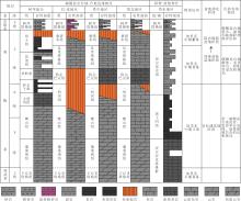
图1
塔里木盆地不同相区岩石地层单元构成及对比"
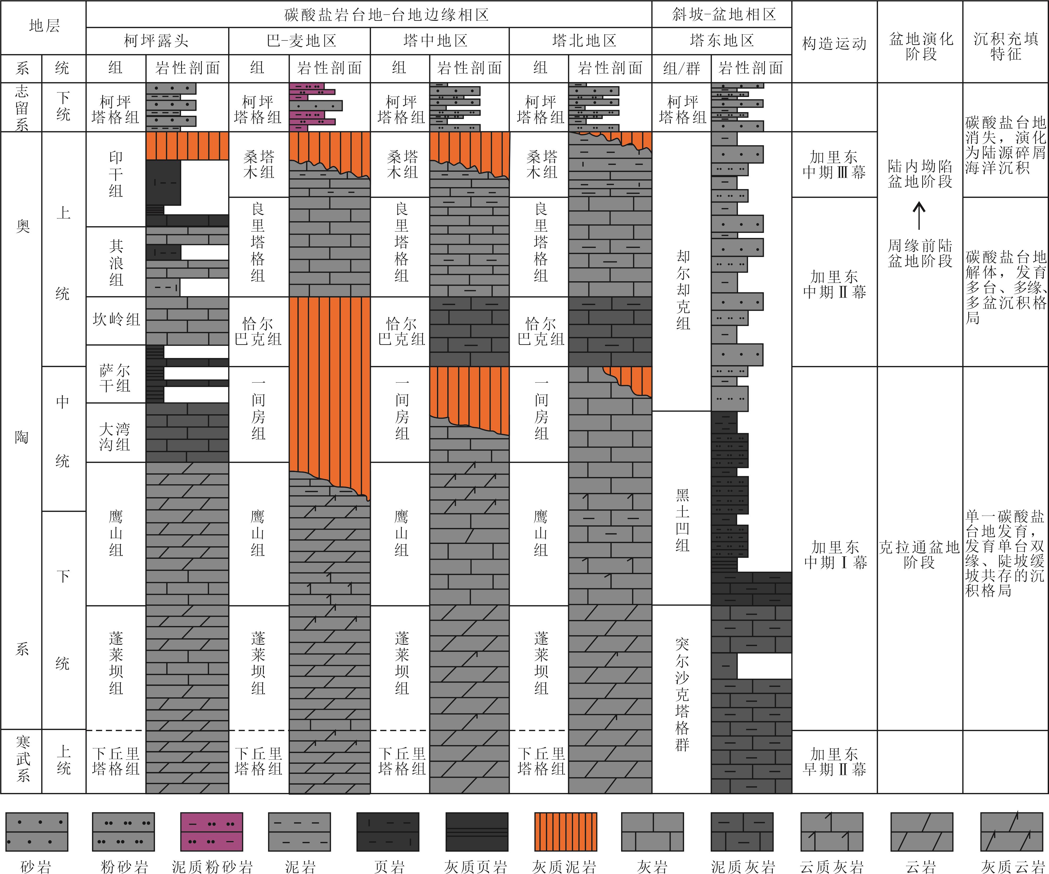
图2
塔里木陆块550~250 Ma古纬度与方位变化"
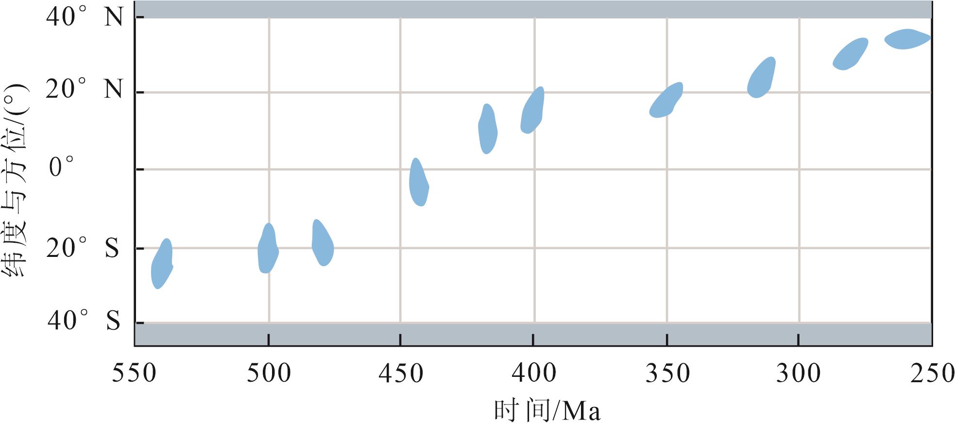
表1
塔里木盆地奥陶系沉积相划分"
| 沉积相 | 亚相 | 微相 | 主要发育层位 |
|---|---|---|---|
| 局限台地 | 局限台坪(潟湖) | 藻席、膏云坪、云坪、灰云坪、含砂云坪 | 蓬莱坝组、鹰山组下部 |
| 台内滩 | 砾屑滩、砂屑滩、生屑滩、鲕粒滩 | ||
| 开阔台地 | 台坪(滩间) | 灰坪、云灰坪 | 鹰山组、一间房组、良里塔格组 |
| 台内滩 | 砂屑滩、砾屑滩、生屑滩 | ||
| 台内礁(点礁) | 粘结岩、障积岩、骨架岩 | ||
| 台间盆地 | 泥质灰泥 | ||
| 深水台地 | 泥质灰泥、灰质泥 | ||
| 淹没台地 | — | — | 恰尔巴克组 |
| 台地边缘 | 台缘滩 | 砾屑滩、砂屑滩、生屑滩(藻屑滩)、鲕粒滩、核形石滩 | 蓬莱坝组、鹰山组、一间房组、良里塔格组 |
| 台缘生物丘或礁 | 粘结岩、障积岩、骨架岩 | ||
| 台缘斜坡 | 上斜坡 | 滑塌、斜坡泥、斜坡灰泥 | 蓬莱坝组、鹰山组、一间房组、恰尔巴克组、良里塔格组 |
| 下斜坡 | 浊流、斜坡泥、斜坡灰泥 | ||
| 陆棚 | 混积陆棚 | 灰泥、陆棚泥 | 蓬莱坝组、鹰山组、一间房组、恰尔巴克组、良里塔格组 |
| (内)陆棚 | 陆棚泥、灰泥、云化灰泥 | ||
| 外陆棚 | 陆棚泥 | ||
| 深水盆地 | 浊积盆地 | 内扇、中扇、外扇 | 一间房组、恰尔巴克组、良里塔格组、桑塔木组 |
| 欠补偿盆地 | 盆地泥、盆地灰泥、硅泥 |

图3
塔里木盆地大湾沟—顺北7井—跃进1X井—托鹰1井—塔深1井—尉犁1井奥陶系沉积相对比"
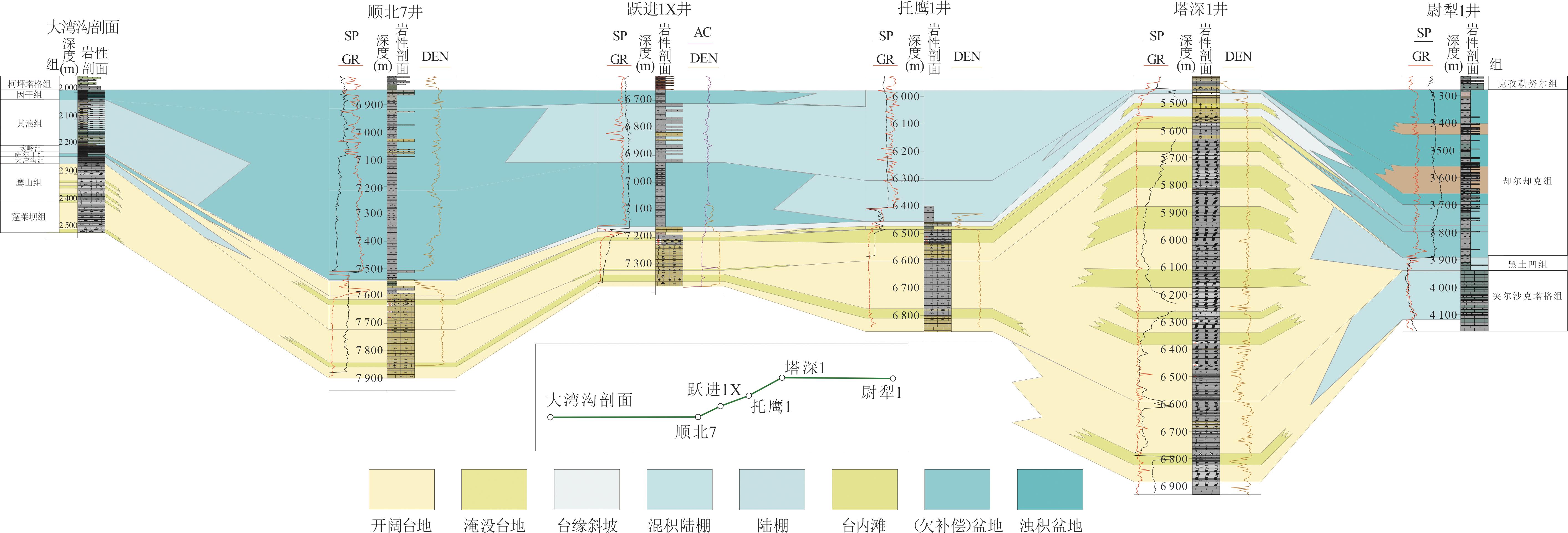
表2
塔里木盆地奥陶系地震相类型划分及特征"
| 沉积相类型 | 地震相类型 | 地震相特征描述 |
|---|---|---|
| 局限台地 | P3,S3,A2,C2,F3 | 楔状波状结构,中振幅,中连续,低频 |
| P1,S2,A2-A3,C2-C3,F2 | 席状亚平行结构,中-弱振幅,中-差连续,中频 | |
| P1,S2,A1-A2,C2-C3,F2-F3 | 席状亚平行结构,强-中振幅,中-差连续,中-低频 | |
| P2,S2,A2,C3,F2-F3 | 披盖状亚平行结构,中振幅,差连续,中-低频 | |
| 开阔台地 | P1,S2,A2-A3,C2-C3,F3 | 席状亚平行结构,中-弱振幅,中-差连续,低频 |
| P2,S2,A2,C2,F3 | 披盖状亚平行结构,中振幅,中连续,低频 | |
| P2,S2,A2-A3,C1-C2,F2 | 披盖状亚平行结构,中-弱振幅,好-中连续,中频 | |
| P2,S2,A2C3,F2 | 披盖状亚平行结构,中振幅,差连续,中频 | |
| P6,S5,A2,C3,F2 | 丘状前积状结构,中振幅,差连续,中频 | |
| 滩(礁) | P4,S4-S5,A2,C2-C3,F2-F3 | 锥状发散-前积结构,中振幅,中-差连续,中-低频 |
| P4-P6,S4-S5,A2,C2,F2 | 锥状-丘状发散-前积结构,中振幅,中连续,中频 | |
| P3,S3,A2,C1-C2,F2 | 楔状波状结构,中振幅,好-中连续,中频 | |
| P3,S3,A2,C3,F2 | 楔状波状结构,中振幅,差连续,中频 | |
| P6,S5,A2,C2,F3 | 丘状前积状结构,中振幅,中连续,低频 | |
| P5,S5,A3,C3,F1 | 扇状前积状结构,弱振幅,差连续,高频 | |
| 台缘 | P4,S4,A2,C2,F2 | 锥状发散结构, 中振幅,中连续,中频 |
| P6,S5,A2,C2,F2 | 丘状前积状结构,中振幅,中连续,中频 | |
| 斜坡 | P1,S2,A2,C2-C3,F2 | 席状亚平行结构,中振幅,中-差连续,中频 |
| P2,S2,A2-A3,C2-C3,F3 | 披盖状亚平行结构,中-弱振幅,中-差连续,低频 | |
| 盆地 | P2,S1-S2,A2,C3,F3 | 披盖状平行-亚平行状结构,中振幅,差连续,低频 |
| P1,S1-S2,A2,C1-C2,F2 | 席状平行-亚平行结构,中振幅,好-中连续,中频 | |
| P1,S1,A2,C1,F2 | 席状平形状结构,中振幅,好连续,中频 |

图4
塔里木盆地奥陶系蓬莱坝组地震相平面分布"
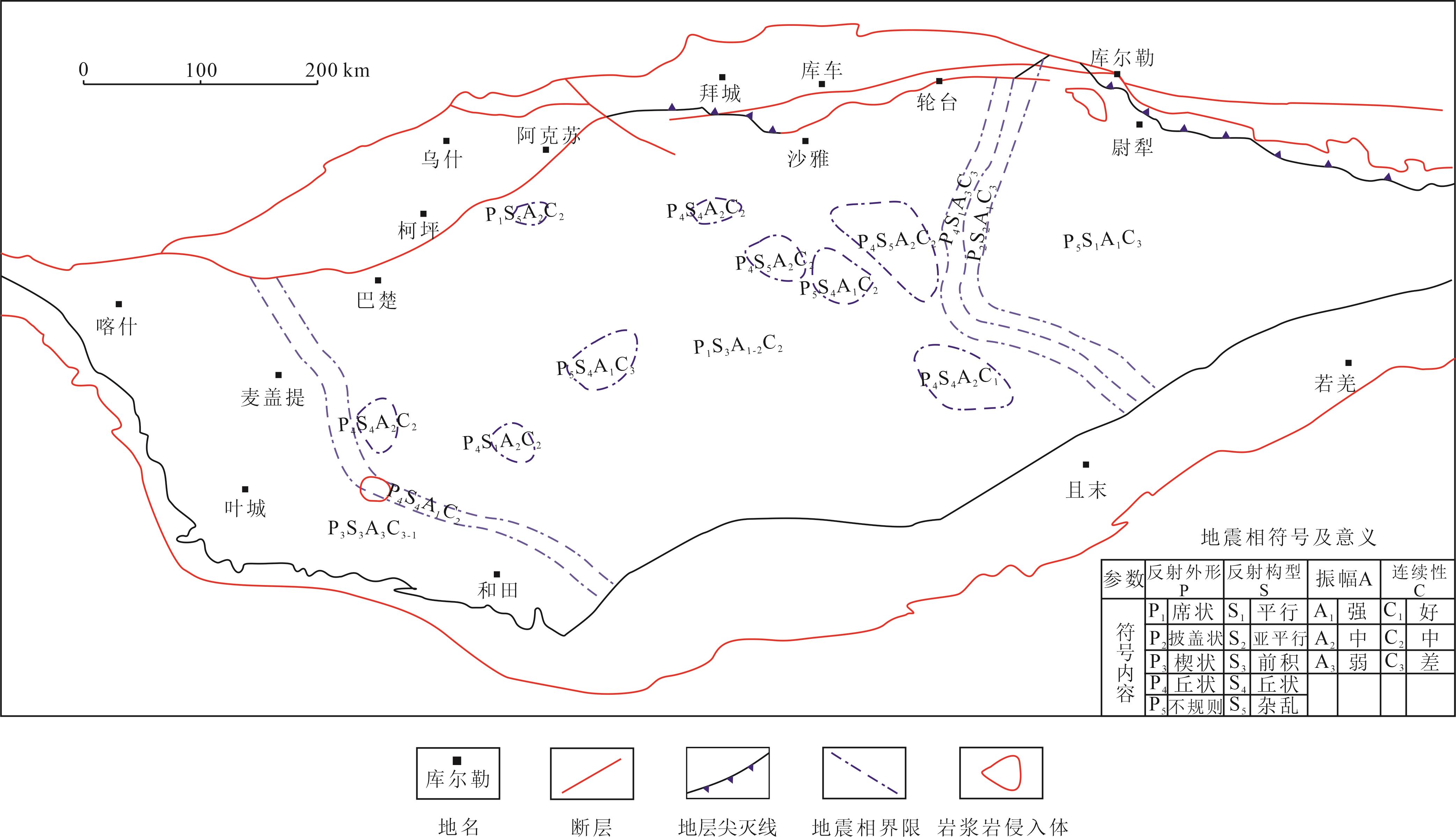
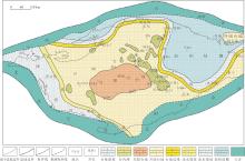
图5
塔里木盆地下奥陶统蓬莱坝组沉积期岩相古地理"

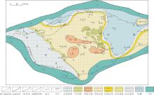
图6
塔里木盆地中-下奥陶统鹰山组沉积期岩相古地理"

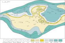
图7
塔里木盆地中奥陶统一间房组沉积期岩相古地理"

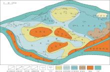
图8
塔里木盆地上奥陶统恰尔巴克组沉积期岩相古地理"

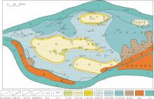
图9
塔里木盆地上奥陶统良里塔格组沉积期岩相古地理"
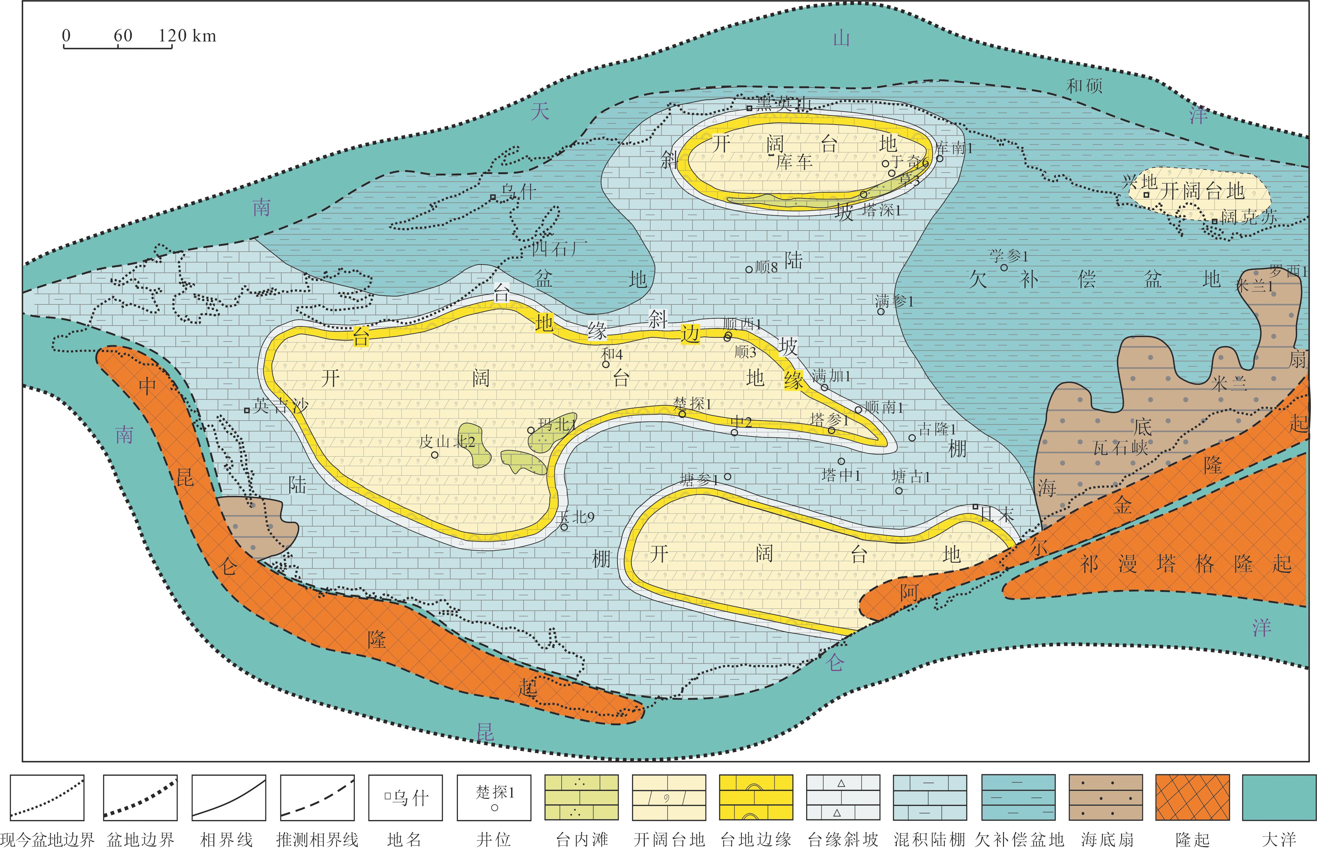
图10
塔里木盆地上奥陶统桑塔木组沉积期岩相古地理"

图11
塔里木盆地奥陶系沉积充填模式"
| 时期 | 沉积模式 |
|---|---|
晚奥陶世晚期 (桑塔木组沉积期) | 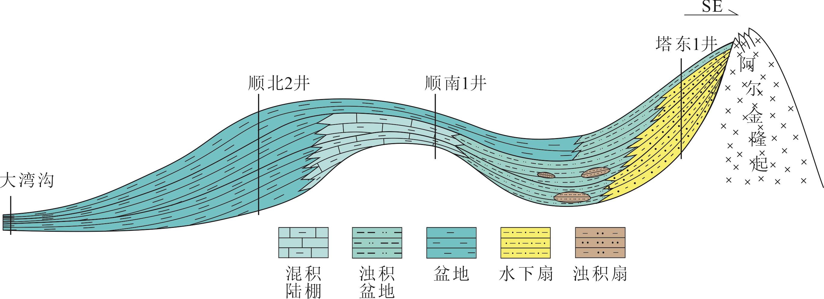 c c |
晚奥陶世早-中期 (恰尔巴克组—良里塔格组沉积期) | 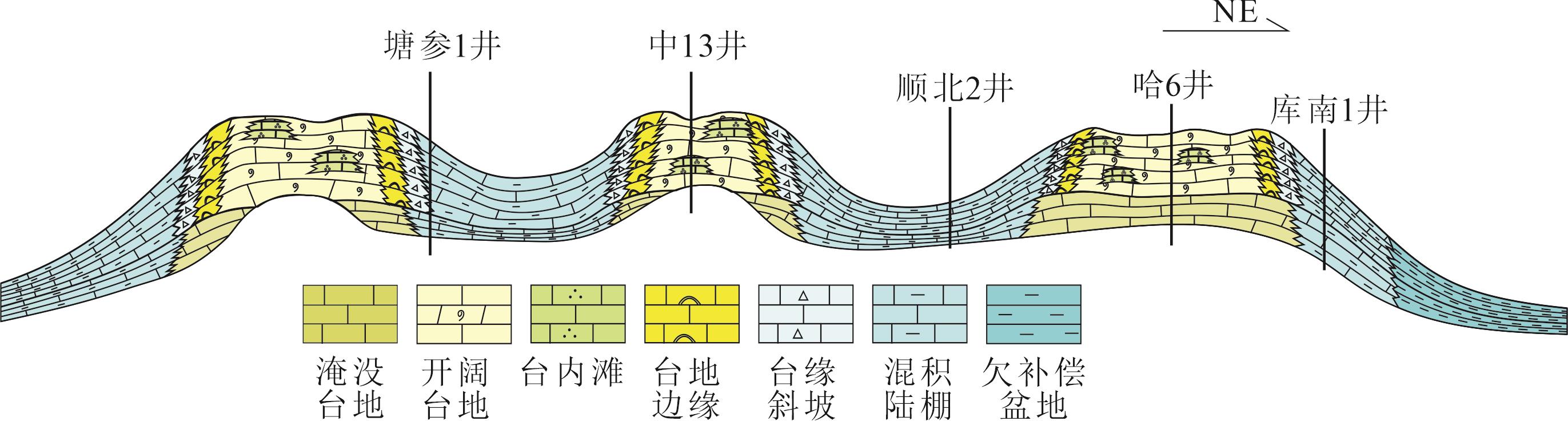 b b |
早-中奥陶世 (蓬莱坝组—一间房组沉积期) | 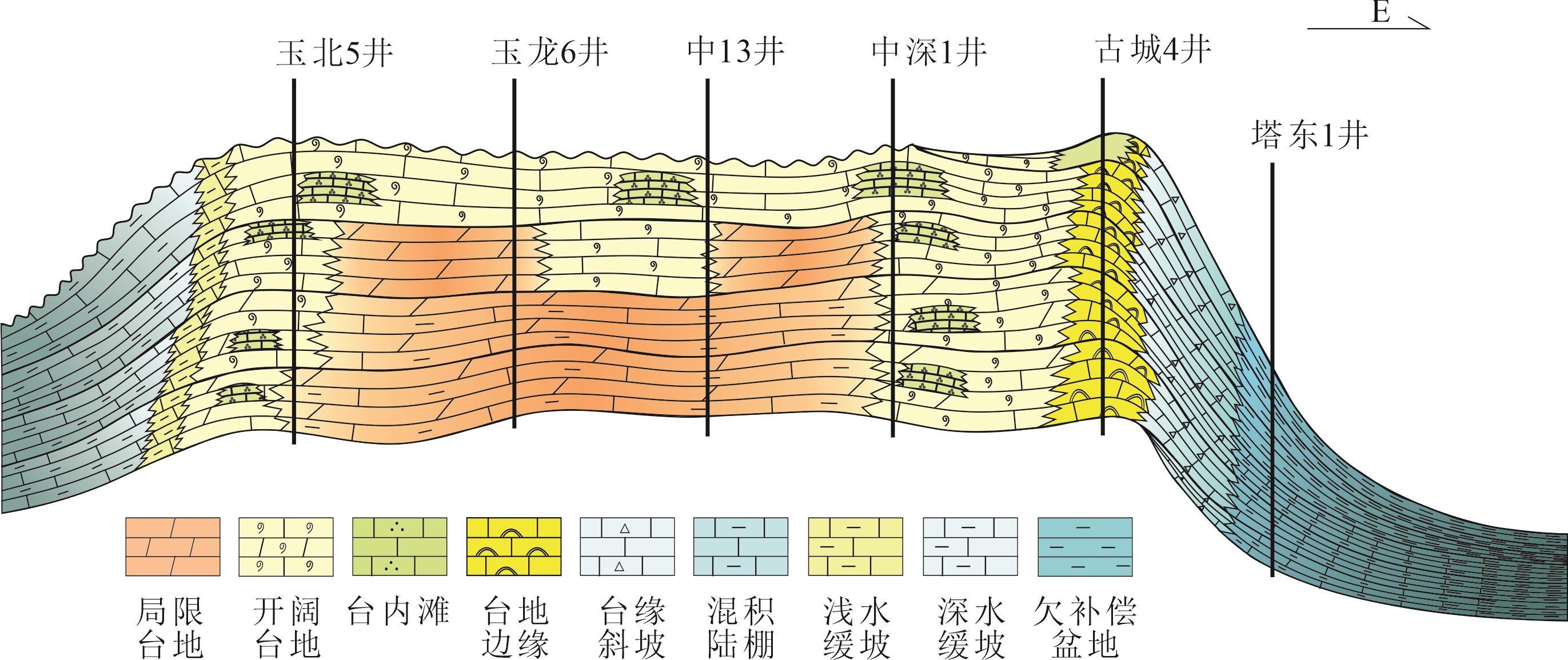 a a |
| 1 | 刘家铎,漆立新,田景春,等. 塔里木盆地构造演化与沉积格架[M]. 北京:科学出版社,2014. |
| Liu Jiaduo, Qi Lixin, Tian Jingchun,et al. Tectonic evolution and sedimentary lattice in the Tarim Basin[M]. Beijing: Science Press,2014. | |
| 2 | 贾承造. 中国塔里木盆地构造特征[M].北京:石油工业出版社,1997. |
| Jia Chengzao. Tectonic features of the Tarim Basin in China[M]. Beijin: Petroleum Industry Press,1997. | |
| 3 | 朱光有, 杨海军, 苏劲, 等. 塔里木盆地海相石油的真实勘探潜力[J]. 岩石学报, 2012,28(3):1333-1347. |
| Zhu Guangyou, Yang Haijun, Su Jin,et al. True exploration potential of marine oils in the Tarim Basin[J]. Acta Petrologica Sinica,2012, 28( 3) : 1333-1347 | |
| 4 | 黎玉战, 徐传会. 塔里木盆地塔河油田发现历程及其意义[J]. 石油实验地质, 2004,26(2): 180-186. |
| Li Yuzhan, Xu Chuanhui. The discovery process of the Tahe oilfield in the Tarim Basin and its significance[J]. Petroleum Geo⁃logy & Experiment, 2004, 26(2): 180-186. | |
| 5 | 翟晓先, 云露. 塔里木盆地塔河大型油田地质特征及勘探思路回顾[J]. 石油与天然气地质, 2008,29(5): 565-573. |
| Zhai Xiaoxian, Yun Lu. Geology of giant Tahe oilfield and a review of exploration thinking in the Tarim Basin[J]. Oil & Gas Geo‑ logy, 2008,29(5): 565-573. | |
| 6 | 梁狄刚. 塔里木盆地轮南—塔河奥陶系油田发现史的回顾与展望[J]. 石油学报, 2008,29(1):153-158. |
| Liang Digang.Review and expectation on the discovery of Ordovi⁃cianLunnan‑Tahe Oilfield, Tarim Basin[J]. Acta Petrolei Sinica, 2008,29(1): 153-158. | |
| 7 | 漆立新. 塔里木盆地下古生界碳酸盐岩大油气田勘探实践与展望[J]. 石油与天然气地质, 2014,35(6):771-779. |
| Qi Lixin.Exploration practice and prospects of giant carbonate field in theLower Paleozoic of Tarim Basin[J]. Oil & Gas Geology,2014,35(6): 771-779. | |
| 8 | 漆立新. 塔里木盆地顺托果勒隆起奥陶系碳酸盐岩超深层油气突破及其意义[J]. 中国石油勘探, 2016,21(3):38-51. |
| Qi Lixin.Oil and gas breakthrough in ultra‑deep Ordovician carbonate formations inShuntuoguole Uplift, Tarim Basin[J]. China Petroleum Exploration, 2016,21(3): 38-51. | |
| 9 | 康玉柱. 塔里木盆地寒武—奥陶系油气勘探重大进展及建议[J].中国西部油气地质,2006,2(3): 237-240. |
| Kang Yuzhu. Major progress and recommendations in Cambrian⁃Ordovician oil and gas exploration in the Tarim Basin[J].West China Petroleum Geosciences,2006,2(3): 237-240. | |
| 10 | 杨宁,吕修祥,周新源,等. 塔里木盆地碳酸盐岩油气聚集带[J].地质学报,2006,80(3):398-405. |
| Yang Ning, Lv Xiuxiang, Zhou Xinyuan, et al. Hydrocarbon accumul ation zones of carbonate in the Tarim Basin[J].Acta Geologica Sinica,2006,80(3): 398-405. | |
| 11 | 周新源,杨海军,韩剑发,等. 中国海相油气田勘探实例之十二塔里木盆地轮南奥陶系油气田的勘探与发现[J].海相油气地质,2009,14(4):67-77. |
| Zhou Xinyuan, Yang Haijun, Han Jianfa, et al.Cases of disco‑ very and exploration of marine fields in China (Part 12):Lunnan Ordovician Oil‑Gas Field in Tarim Basin[J].Marine Origin Petroleum Geology,2009,14(4): 67-77. | |
| 12 | 贾承造,魏国齐,王良杰,等.中国塔里木盆地构造特征与油气[M].北京:石油工业出版社,1997:1-438. |
| Jia Chengzao, Wei Guoqi, Wang Liangjie, et al. Tectonic characteristics and oil and gas in the Tarim Basin of China[M]. Beijing: Petroleum Industry Press,1997:1-438. | |
| 13 | 张光亚,刘伟,杨海军,等.塔里木克拉通寒武纪—奥陶纪原型盆地与岩相古地理[M].北京:地质出版社,2013:41-159. |
| Zhang Guangya, Liu Wei, Yang Haijun, et al. Tarim Kraton Cam⁃brian‑Ordovician prototype basin and litigy paleogeography[M].Beijing:Geological Publishing House,2013: 41-159. | |
| 14 | 许效松,汪正江,万方,等.塔里木盆地早古生代构造古地理演化与烃源岩[J].地学前缘,2005,12(3):49-57. |
| Xu Xiaosong, Wang Zhengjiang, Wan Fang, et al. Tectonic paleogeographic evolution and source rocks of the Early Paleozoiin the Tarim Basin[J]. Earth Science Frontiers, 2005,12(3): 49- | |
| 57 | |
| 15 | 何登发,周新源,张朝军,等.塔里木地区奥陶纪原型盆地类型及其演化[J].科学通报,2007,52(S1):126-134. |
| He Dengfa, Zhou Xinyuan, Zhang Zhaojun, et al. Types of Ordovician prototype basins in the Tarim region and their evolution[J]. Chinese Science Bulletin,2007,52(S1): 126-134. | |
| 16 | 冯増昭.塔里木地区寒武纪和奥陶纪岩相古地理[M].北京:地质出版社,2005: 1-179. |
| Feng Zengzhao. Cambrian and Ordovician lithofacies paleogeography of the Tarim region[M]. Beijing: Geological Publishing Hou⁃se, 2005: 1-179. | |
| 17 | 赵宗举,罗家洪,张运波,等.塔里木盆地寒武纪层序岩相古地理[J].石油学报,2011,32(6): 937-947. |
| Zhao Zongju, Luo Jiahong, Zhang Yunbo, et al. Lithofacies paleogeography of Cambrian sequences in the Tarim Basin[J]. Acta Petrolei Sinica,2011,32(6): 937-947. | |
| 18 | 赵宗举,吴兴宁,潘文庆,等.塔里木盆地奥陶纪层序岩相古地理[J].沉积学报,2009,27(5):939-954. |
| Zhao Zongju, Wu Xingning, Pan Wenqing, et al. Sequence lithofacies paleogeography of Ordovician in Tarim Basin[J]. Acta Sedimentologica Sinica,2009,27(5): 939-954. | |
| 19 | 何登发,贾承造,李德生,等.塔里木多旋回叠合盆地的形成与演化[J].石油与天然气地质,2005,26(1): 64-77. |
| He Dengfa, Jia Chengzao, Li Desheng, et al. Formation and evolution of polycyclic superimposed Tarim Basin[J]. Oil & Gas Geolo‑ gy, 2005,26(1): 64-77. | |
| 20 | 吕海涛, 丁勇, 耿锋. 塔里木盆地奥陶系油气成藏规律与勘探方向[J]. 石油与天然气地质, 2014,35(6):798-805. |
| Lv Haitao, Ding Yong, Geng Feng, et al. Hydrocarbon accumulation patterns and favorable exploration areas of the Ordovician in Tarim Basin[J]. Oil & Gas Geology, 2014,35(6): 798-805. | |
| 21 | 马明侠, 陈新军, 张学恒. 塔里木盆地塔中地区寒武—奥陶系沉积特征及构造控制[J]. 石油实验地质, 2006,28(6):549- |
| 553 | Ma Mingxia, Chen Xinju, Zhang Xueheng, et al.The Cambrian⁃Ordovician sedimentary features and structural control in the Central Tarim Area[J]. Petroleum Geology &Experiment, 2006,28(6): 549-553. |
| 22 | 王招明,田军,王清华,等. 塔里木盆地油气勘探与实践[M]. 北京:石油工业出版社,2004. |
| Wang Zhaoming, Tian Jun, Wang Qinghua, et al. Oil and gas exploration and practice in the Tarim Basin[M]. Beijing: Petroleum Industry Press,2004. | |
| 23 | 高志前,樊太亮,焦志峰,等.塔里木盆地寒武—奥陶系碳酸盐岩台地样式及其沉积响应特征[J]. 沉积学报,2006,24(1): 19-27. |
| Gao Zhiqian, Fan Tailiang, Jiao Zhifeng, et al.The structural types and depositional characteristics of Carbonate platfomm in the Cambrian Ordovician of Tarim Basin[J]. Acta Sedimentologica Sinica, 2006,24(1): 19-27. | |
| 24 | 许效松,刘宝珺,牟传龙,等. 中国中西部海相盆地分析与油气资源[M]. 北京: 地质出版社,2004. |
| Xu Xiaosong, Liu Baojun, Mu Chuanlong, et al. Marine basin analysis and its oil and gas resources of Central‑Western China[M]. Beijing: Geological Publishing House,2004. | |
| 25 | 汪业勇, 张博, 李辉, 等. 塔里木盆地下奥陶统蓬莱坝组沉积相研究[J]. 天然气技术与经济, 2015,9(1): 8-12. |
| Wang Yeyong, Zhang Bo, Li Hui, et al.Sedimentary facies of the Lower Ordovi‑cian Penglaizhen Formation, Tarim Basin WANG Yeyong[J]. Natural Gas Technology and Economy, 2015,9(1): 8-12. | |
| 26 | 胡九珍, 冉启贵, 刘树根, 等. 塔里木盆地东部地区寒武系—奥陶系沉积相分析[J]. 岩性油气藏, 2009,21(2): 70-75. |
| Hu Jiuzhen, Ran Qigui, Liu Shugen, et al.Sedimentary facies analysis of Cambrian‑Ordovician in eastern Tarim Basin[J]. Lithologic Reservoirs, 2009,21(2): 70-75. | |
| 27 | 高志前, 王惠民, 樊太亮, 等. 塔里木盆地寒武—奥陶系沉积相沉积体系及其组合序列[J]. 新疆石油天然气, 2005,1(1):30-35. |
| Gao Zhiqian, Wang Huiming, Fan Tailiang,et al.Facies, sedimentary system and assembled sequence in Cambrian‑Ordovician of Tarim Basin[J]. Journal of Xinjiang & Gas, 2005,1(1): 30-35. | |
| 28 | 刘颜, 谢锐杰. 塔里木盆地塔中地区良里塔格组沉积相研究[J]. 中国锰业, 2016,(5):38-40. |
| Liu Yan, Xie Ruijie.Sedimentary facies of Lianglitag Formation in Tazhong Area, Tarim Basin[J].China’s Manganese Industry,2016,(5):38-40. | |
| 29 | 蔡习尧, 李慧莉, 马玉春, 等. 塔里木盆地古城墟隆起奥陶系沉积相特征[J].中南大学学报(自然科学版),2006:37(S):155-161. |
| Cai Xiyao, Li Huili, Ma Yuchun, et al.Characteristic of sedimentary facies of Guchengxu Uplift Ordovician at Tarim Basin[J]. Journal of Central South University (Science and Technology),2006:37(S):155-161. | |
| 30 | 胡晓兰, 樊太亮, 高志前, 等. 塔里木盆地奥陶系碳酸盐岩颗粒滩沉积组合及展布特征[J]. 沉积学报, 2014,32(3): 418-428. |
| Hu Xiaolan, Fan Tailiang, Gao Zhiqian,et al.Depositional combination characteristics and distributionof ordovician carbonate shoals in the Tarim Basin[J]. Acta Sedimentologica Sinica, 2014,32(3): 418-428. | |
| 31 | 周明, 罗平, 董琳, 等. 塔里木盆地柯坪地区奥陶系鹰山组台内滩沉积特征[J]. 沉积学报, 2016,34(5): 951-962. |
| Zhou Ming, Luo Ping, Dong Lin, et al.Sedimentary characteristics of Lower ‑Middle Ordovician Yingshan Formation Carbonate intraplatform Shoals in Keping area, Tarim Basin[J]. Acta Sedimentologica Sinica, 2016,34(5): 951-962. | |
| 32 | 焦志峰, 吴华, 李岩, 等. 塔里木盆地孔雀河地区寒武—奥陶系沉积相与沉积体系[J]. 新疆地质, 2004,22(2): 151-154. |
| Jiao Zhifeng, Wu Hua, Li Yan, et al.Sedimentary facies and depositional system of Cambrian‑Ordovician Kong Quehe Region, Tarim Basin [J]. Xingjiang Geology, 2004,22(2): 151-154. | |
| 33 | 罗少辉, 李九梅, 张旭光, 等. 塔里木盆地玉北地区奥陶系沉积相与沉积演化模式[J]. 海相油气地质, 2017,22(3):23-29. |
| Luo Shaohui, Li Jiumei, Zhang Xuguang, et al.Depositional facies and sedimentary evolution modelof Ordovician in Yubei area, Tarim Basin[J]. Marine Origin Petroleum Geology, 2017,22(3): 23-29. | |
| 34 | 马宇驰. 塔里木盆地玉北地区奥陶系层序地层及沉积相研究[D]. 北京:中国石油大学(北京), 2016. |
| Ma Yuchi. Study on Ordovician sequence stratigraphy and sedimentary facies in the Yubei region of the Tarim Basin[D]. Beijing:China Univer sity of Petroleum,Beijing,2016. | |
| 35 | 韩杰, 吴萧, 潘文庆, 等. 塔里木盆地西北缘巴楚—乌什露头区奥陶系沉积相特征[J]. 沉积学报, 2015,33(4): 764-772. |
| Han Jie, Wu Xiao, Pan Wenqing, et al.Ordovician sedimentary facies characteristic in Bachu‑Wushi outcrop Area of Northwest Tarim Basin[J]. Acta Sedimantologica Sinica, 2015,33(4): 764-772. | |
| 36 | Pomar L, Guillocheau F, Calves A G. Types of carbonate platforms: A genetic approach[J]. Basin Research, 2001,13(3): 313-334. |
| 37 | Lin C, Yang H, Liu J, et al. Sequence architecture and depositional evolution of the Ordovician carbonate platform margins in the Tarim Basin and its response to tectonism andsea‑level change[J]. Basin Research, 2012(24): 559-582. |
| 38 | Razin F G A G P. Carbonate platform margins and associated turbiditic systems in response to high aggradation rates the Palaeogene platform margin in Oman[C]// Geophysical Research Abstracts. Vienna, Austria: EGU,2012. |
| 39 | 丁梦. 塔里木盆地寒武-奥陶系碳酸盐岩台地边缘结构样式及展布[D]. 北京:中国地质大学(北京), 2013. |
| Ding Meng. The edge structure and spread of cambrian‑ordovician carbonate terraces in the Tarim Basin[D]. Beijing: China University of Petroleum,Beijing,2013. | |
| 40 | 王冠, 樊太亮, 刘海龙. 塔里木盆地塔中—古城地区奥陶系碳酸盐岩台地边缘相特征及演化[J]. 现代地质, 2014,28(5):995-1007. |
| Wang Guan, Fan Tailiang, Liu Hailong.Characteristics and evolution of Ordovician Carbonate platform marginal facies in Tazhong⁃Gucheng area, Tarim Basin[J]. Geoscience, 2014,28(5): 995-1007. | |
| 41 | 孟祥杰, 高志前, 樊太亮, 等. 塔里木盆地中-下奥陶统台缘结构特征及油气指示意义[J]. 新疆石油地质, 2015,36(3):293-298. |
| Meng Xiangjie, Gao Zhiqian, Fan Tailiang, et al.Structural characteristics of carbonate platform margins in Lower‑Middle Ordovician of Tarim Basin and related hydrocarbon implication[J]. Xin‑ jiang Petroleum Geology, 2015,36(3): 293-298. | |
| 42 | 贺锋, 林畅松, 刘景彦, 等. 塔东南寒武系—中下奥陶统碳酸盐岩台缘带的迁移与相对海平面变化的关系[J]. 石油与天然气地质, 2017,38(4):711-721. |
| He Feng, Lin Changsong, Liu Jingyan, et al.Migration of the Cambrian and Middle‑Lower Ordovician carbonate platform marginand its relation to relative sea level changes in southeastern Tarim Basin[J]. Oil & Gas Geology, 2017,38(4): 711-721. |
| [1] | 韩鹏远, 丁文龙, 杨德彬, 张娟, 马海陇, 王生晖. 塔里木盆地塔河油田S80走滑断裂发育特征及其对奥陶系储层的控制作用[J]. 石油与天然气地质, 2024, 45(3): 770-786. |
| [2] | 张艳秋, 陈红汉, 王燮培, 王彭, 苏丹梅, 谢舟. 塔里木盆地富满油田走滑断裂带通源性评价[J]. 石油与天然气地质, 2024, 45(3): 787-800. |
| [3] | 丁文龙, 李云涛, 韩俊, 黄诚, 王来源, 孟庆修. 碳酸盐岩储层高精度构造应力场模拟与裂缝多参数分布预测方法及其应用[J]. 石油与天然气地质, 2024, 45(3): 827-851. |
| [4] | 曹自成, 云露, 漆立新, 李海英, 韩俊, 耿锋, 林波, 陈菁萍, 黄诚, 毛庆言. 塔里木盆地顺北地区顺北84X井超千米含油气重大发现及其意义[J]. 石油与天然气地质, 2024, 45(2): 341-356. |
| [5] | 杨德彬, 鲁新便, 鲍典, 曹飞, 汪彦, 王明, 谢润成. 塔里木盆地北部奥陶系海相碳酸盐岩断溶体油藏成因类型及特征再认识[J]. 石油与天然气地质, 2024, 45(2): 357-366. |
| [6] | 张长建, 杨德彬, 蒋林, 姜应兵, 昌琪, 马雪健. 塔里木盆地塔河北部“过溶蚀残留型”断溶体发育特征及其成因[J]. 石油与天然气地质, 2024, 45(2): 367-383. |
| [7] | 万俊雨, 朱建辉, 姚素平, 张毅, 李春堂, 张威, 姜海健, 王杰. 鄂尔多斯盆地中、东部奥陶系马家沟组成烃生物及烃源岩地球生物学评价[J]. 石油与天然气地质, 2024, 45(2): 393-405. |
| [8] | 黎瑞, 杨娇, 柴愈坤, 王华, 戴建文, 邓永辉, 孙爽, 马肖琳, 田腾飞. 大角度波浪控制下的浪成砂坝新模式[J]. 石油与天然气地质, 2024, 45(2): 530-541. |
| [9] | 江同文, 邓兴梁, 曹鹏, 常少英. 塔里木盆地富满断控破碎体油藏储集类型特征与注水替油效果[J]. 石油与天然气地质, 2024, 45(2): 542-552. |
| [10] | 牛月萌, 韩俊, 余一欣, 黄诚, 林波, 杨帆, 余浪, 陈俊宇. 塔里木盆地顺北西部地区火成岩侵入体发育特征及其与断裂耦合关系[J]. 石油与天然气地质, 2024, 45(1): 231-242. |
| [11] | 张三, 金强, 史今雄, 胡明毅, 段梦悦, 李永强, 张旭栋, 程付启. 塔北地区奥陶系地下河溶洞充填规律与储集性能[J]. 石油与天然气地质, 2023, 44(6): 1582-1594. |
| [12] | 康志江, 张冬梅, 张振坤, 王睿奇, 姜文斌, 刘坤岩. 深层缝洞型油藏井间连通路径智能预测技术[J]. 石油与天然气地质, 2023, 44(5): 1290-1299. |
| [13] | 胡伟, 徐婷, 杨阳, 伦增珉, 李宗宇, 康志江, 赵瑞明, 梅胜文. 塔里木盆地超深油气藏流体相行为变化特征[J]. 石油与天然气地质, 2023, 44(4): 1044-1053. |
| [14] | 张坦, 姚威, 赵永强, 周雨双, 黄继文, 范昕禹, 罗宇. 塔里木盆地巴麦地区石炭系卡拉沙依组年代标尺及地层剥蚀厚度精细计算[J]. 石油与天然气地质, 2023, 44(4): 1054-1066. |
| [15] | 郭宏辉, 冯建伟, 赵力彬. 塔里木盆地博孜—大北地区被动走滑构造特征及其对裂缝发育的控制作用[J]. 石油与天然气地质, 2023, 44(4): 962-975. |
| 阅读次数 | ||||||
|
全文 |
|
|||||
|
摘要 |
|
|||||