

石油与天然气地质 ›› 2020, Vol. 41 ›› Issue (4): 763-775.doi: 10.11743/ogg20200410
姚尧1( ), 何治亮2(), 李慧莉1, 张瑜1, 高晓鹏1, 王康宁1, 焦存礼1
收稿日期:2020-04-19
出版日期:2020-08-01
发布日期:2020-08-11
第一作者简介:姚尧(1986—),女,博士、工程师,沉积学。E-mail:基金项目:
Yao Yao1(), Zhiliang He2(), Huili Li1, Yu Zhang1, Xiaopeng Gao1, Kangning Wang1, Cunli Jiao1
Received:2020-04-19
Online:2020-08-01
Published:2020-08-11
摘要:
中-上奥陶统萨尔干组烃源岩是塔里木盆地重要的海相烃源岩。针对阿瓦提断陷中-上奥陶统埋深大、缺乏钻井进行层位标定,以及萨尔干组烃源岩发育层段的地震响应特征不明的问题,用传统的技术手段识别该套烃源岩的分布范围可能难以取得好的效果。通过对柯坪地区露头剖面中-上奥陶统萨尔干组及其上下地层不同岩性及地层结构的认识,建立沉积地质模型,进行地震正演模拟,将地质模型和地震模型有机地结合起来,为烃源岩地震相识别追踪提供依据;在对研究区内二维地震测线逐条解释的基础上,依据地震反射波组的反射特征,进行地震相-沉积相分析;针对露头发育烃源岩而断陷内未有钻井揭示的地区,建立了海相烃源岩识别方法和流程,对研究区中-上奥陶统萨尔干组烃源岩进行了重新识别和空间展布预测。研究表明,萨尔干组烃源岩的发育受海平面上升控制作用明显,属于深水陆棚相沉积;萨尔干组烃源岩在区内广泛分布,厚度范围约为0~120 m,在西南部最厚,受控于阿恰断裂和吐木休克断裂,向东北部减薄,向北超覆尖灭于英买3井以南,向东至阿-满过渡带西缘仍有少量分布。
中图分类号:

图1
塔里木盆地阿瓦提断陷位置 a.露头剖面、井位及区域二维地震测线分布; b.塔里木盆地构造区划"
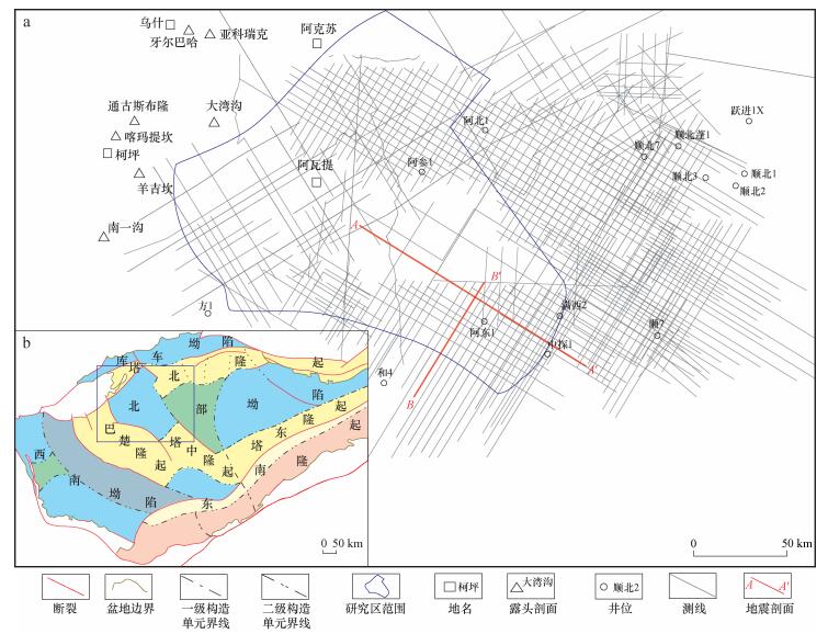
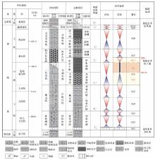
图2
塔里木盆地阿瓦提断陷及周缘奥陶系层序地层划分"
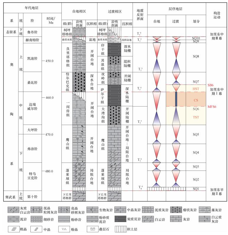

图3
塔里木盆地阿瓦提断陷及周缘一间房组沉积期剖面沉积充填特征 a.近南北向剖面C—C′沉积充填特征; b.近东西向剖面D—D′沉积充填特征; c.C—C′和D—D′剖面位置"
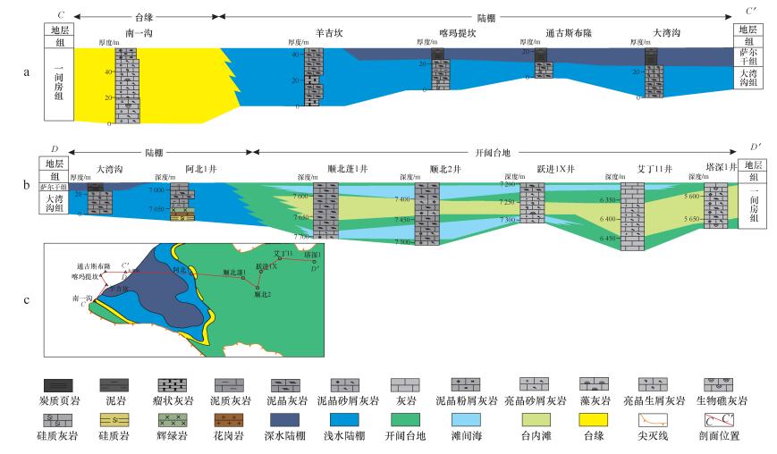

图4
塔里木盆地柯坪地区中-上奥陶统沉积相对比"
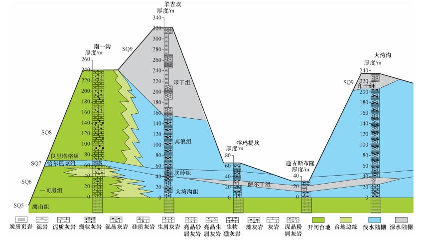
图5
塔里木盆地柯坪地区萨尔干组简单地质模型(a)及其对应的正演模拟速度模型与地震剖面(b)"


图6
塔里木盆地阿瓦提断陷内A—A′测线(a)和B—B′测线(b)地震相 (①—⑧为地震相类型,具体参考表1。) "
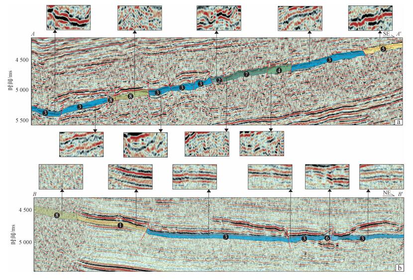
表1
塔里木盆地阿瓦提断陷中-上奥陶统SQ6内的地震相类型"
| 编号 | 地震相类型 | 典型地震剖面 |
| ① | 低频强振幅连续平行反射 |  |
| ② | 中频强振幅低连续反射 | 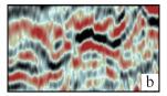 |
| ③ | 中频强振幅连续平行反射 | 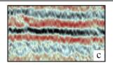 |
| ④ | 中频中振幅低连续反射 | 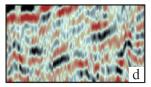 |
| ⑤ | 低频强振幅中连续平行反射 | 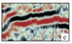 |
| ⑥ | 中频强振幅中连续亚平行反射 | 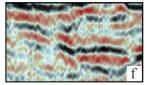 |
| ⑦ | 高频弱振幅低连续反射 | 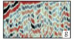 |
| ⑧ | 杂乱反射 |  |
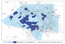
图7
塔里木盆地阿瓦提断陷萨尔干组烃源岩地震相平面分布"
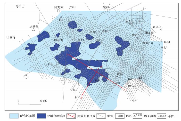
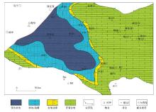
图8
塔里木盆地阿瓦提断陷萨尔干组沉积相"
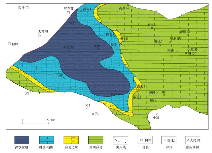

图9
塔里木盆地阿瓦提断陷萨尔干组烃源岩等厚图"
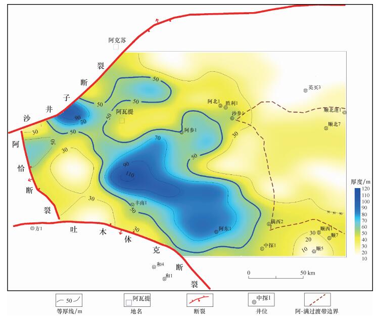

图10
塔里木盆地阿瓦提断陷T74古地貌(现今)"

| 1 | 范璞, 马宝林. 塔里木油气地质总论[M]. 北京: 科学出版社, 1990: 1- 258. |
| Fan Pu , Ma Baolin . General theory of petroleum geology in Tarim[M]. Beijing: Science Press, 1990: 1- 258. | |
| 2 | 康玉柱. 中国塔里木盆地石油地质特性及资源评价[M]. 北京: 地质出版社, 1996: 1- 348. |
| Kang Yuzhu . Petroleum geological characteristics and resource evaluation of Tarim Basin, China[M]. Beijing: Geological Publishing House, 1996: 1- 348. | |
| 3 | 贾承造. 中国塔里木盆地构造特征与油气[M]. 北京: 石油工业出版社, 1997: 185- 200. |
| Jia Chengzao . Tectonic characteristics and petroleum, Tarim Basin, China[M]. Beijing: Petroleum Industry Press, 1997: 185- 200. | |
| 4 | 翟光明, 何文渊. 塔里木盆地石油勘探实现突破的重要方向[J]. 石油学报, 2004, 25 (1): 1- 7. |
| Zhai Guangming , He Wenyuan . An important petroleum exploration region in Tarim Basin[J]. Acta Petrolei Sinica, 2004, 25 (1): 1- 7. | |
| 5 |
赵靖舟. 塔里木盆地北部寒武-奥陶系海相烃源岩重新认识[J]. 沉积学报, 2001, 19 (1): 117- 124.
doi: 10.3969/j.issn.1000-0550.2001.01.020 |
|
Zhao Jingzhou . Evolution on the Cambrian-Ordovician marine source rocks from the North Tarim Basin[J]. Acta Sedimentologica Sinica, 2001, 19 (1): 117- 124.
doi: 10.3969/j.issn.1000-0550.2001.01.020 |
|
| 6 | 王大锐, 宋立生. 论我国海相中上奥陶统烃源岩的形成条件——以塔里木盆地为例[J]. 石油学报, 2002, 23 (1): 31- 34. |
| Wang Darui , Song Lisheng . A thesis about forming conditions of marine Middle-Upper Ordovian source rocks in China[J]. Acta Petrolei Sinica, 2002, 23 (1): 31- 34. | |
| 7 | 张水昌, 张宝民, 王飞宇, 等. 中-上奥陶统:塔里木盆地的主要油源层[J]. 海相油气地质, 2000, 5 (1-2): 16- 22. |
| Zhang Shuichang , Zhang Baomin , Wang Feiyu , et al. Middle-Upper Ordovician:Main source rock of the Tarim Basin[J]. Marine Origin Petroleum Geology, 2000, 5 (1-2): 16- 22. | |
| 8 |
赵宗举, 周新源, 郑兴平, 等. 塔里木盆地主力烃源岩的诸多证据[J]. 石油学报, 2005, 26 (3): 10- 15.
doi: 10.3321/j.issn:0253-2697.2005.03.002 |
|
Zhao Zongju , Zhou Xinyuan , Zheng Xingping , et al. Evidences of chief source rock in Tarim Basin[J]. Acta Petrolei Sinica, 2005, 26 (3): 10- 15.
doi: 10.3321/j.issn:0253-2697.2005.03.002 |
|
| 9 |
顾忆, 赵永强, 贾存善, 等. 塔里木盆地阿瓦提坳陷油气资源潜力分析[J]. 石油实验地质, 2012, 34 (3): 257- 266.
doi: 10.3969/j.issn.1001-6112.2012.03.005 |
|
Gu Yi , Zhao Yongqiang , Jia Cunshan , et al. Analysis of hydrocarbon resource potential in Awati Depression of Tarim Basin[J]. Petroleum Geology & Experiment, 2012, 34 (3): 257- 266.
doi: 10.3969/j.issn.1001-6112.2012.03.005 |
|
| 10 | 吕修祥, 白忠凯, 谢玉权, 等. 塔里木盆地西北缘柯坪地区油气勘探前景再认识[J]. 沉积学报, 2014, 32 (4): 766- 775. |
| Lv Xiuxiang , Bai Zhongkai , Xie Yuquan , et al. Reconsideration on petroleum exploration prospects in the Kalpin Thrust Belt of Northwestern Tarim Basin[J]. Acta Sedimentologica Sinica, 2014, 32 (4): 766- 775. | |
| 11 |
卢玉红, 钱玲, 张海祖, 等. 塔里木阿瓦提凹陷乌鲁桥油苗地化特征及来源[J]. 海相油气地质, 2008, 13 (2): 45- 51.
doi: 10.3969/j.issn.1672-9854.2008.02.006 |
|
Lu Yuhong , Qian Ling , Zhang Haizu , et al. Origin and geochemical characteristics of Wuluqiaooil seepage in Awati Sag, Tarim Basin[J]. Marine Origin Petroleum Geology, 2008, 13 (2): 45- 51.
doi: 10.3969/j.issn.1672-9854.2008.02.006 |
|
| 12 |
吕修祥, 李建交, 赵风云, 等. 塔里木盆地西部环阿瓦提凹陷区油气勘探前景再认识[J]. 海相油气地质, 2007, 12 (3): 10- 14.
doi: 10.3969/j.issn.1672-9854.2007.03.003 |
|
Lv Xiuxiang , Li Jianjiao , Zhao Fengyun , et al. Re-cognition on petroleum exploration prospect of marine carbonates in western Tarim Basin[J]. Marine Origin Petroleum Geology, 2007, 12 (3): 10- 14.
doi: 10.3969/j.issn.1672-9854.2007.03.003 |
|
| 13 | 邓尚, 李慧莉, 张仲培, 等. 塔里木盆地顺北及邻区主干走滑断裂带差异活动特征及其与油气富集的关系[J]. 石油与天然气地质, 2018, 39 (5): 878- 888. |
| Deng Shang , Li Huili , Zhang Zhongpei , et al. Characteristics of differe-ntial activities in major strike-slip fault zones and their control on hydrocarbon enrichment in Shunbei area and its surroundings, Tarim Basin[J]. Oil & Gas Geology, 2018, 39 (5): 878- 888. | |
| 14 | 张水昌, 梁狄刚, 张宝民, 等. 塔里木盆地海相油气的生成[M]. 北京: 石油工业出版社, 2004: 123- 135. |
| Zhang Shuichang , Liang Digang , Zhang Baomin , et al. Marine hydrocarbon generation of Tarim Basin[M]. Beijing: Petroleum Industry Press, 2004: 123- 135. | |
| 15 | 梁狄刚, 张水昌, 张宝民, 等. 从塔里木盆地看中国海相生油问题[J]. 地学前缘, 2000, 7 (4): 534- 547. |
| Liang Digang , Zhang Shuichang , Zhang Baomin , et al. Understanding on marine oil generation in China Based on Tarim Basin[J]. Earth Science Frontiers, 2000, 7 (4): 531- 547. | |
| 16 |
张宝民, 赵孟军, 肖中尧, 等. 塔里木盆地优质气源岩特征[J]. 新疆石油地质, 2000, 21 (1): 33- 37.
doi: 10.3969/j.issn.1001-3873.2000.01.009 |
|
Zhang Baomin , Zhao Mengjun , Xiao Zhongyao , et al. Characteristics of premium Gas source rocks in Tarim Basin[J]. Xinjiang Petroleum Geology, 2000, 21 (1): 33- 37.
doi: 10.3969/j.issn.1001-3873.2000.01.009 |
|
| 17 | 王飞宇, 杜治利, 张宝民, 等. 柯坪剖面中上奥陶统萨尔干组黑色页岩地球化学特征[J]. 新疆石油地质, 2008, 29 (6): 687- 689. |
| Wang Feiyu , Du Zhili , Zhang Baomin , et al. Geochemistry of Salgan black shales of Middle-Upper Ordovician in Keping outcrop, Tarim Basin[J]. Xinjiang Petroleum Geology, 2008, 29 (6): 687- 689. | |
| 18 | 马璐, 张智礼, 王冠, 等. 塔里木柯坪地层区中-上奥陶统萨尔干组碳酸盐岩微相和古地理[J]. 微体古生物学报, 2013, 30 (4): 344- 352. |
| Ma Lu , Zhang Zhili , Wang Guan , et al. Microfacies of the carbonates an palaeogeography of the Saergan Formation(Middle-Upper Ordovician), Kalpin stratigraphic region, Tarim, NW China[J]. Acta Micro-palaeontologica Sinica, 2013, 30 (4): 344- 352. | |
| 19 | 韩杰, 吴萧, 潘文庆, 等. 塔里木盆地西北缘巴楚-乌什露头区奥陶系沉积相特征[J]. 沉积学报, 2015, 33 (4): 764- 772. |
| Han Jie , Wu Xiao , Pan Wenqing , et al. Ordovician sedimentary facies characteristic in Bachu-Wushi outcrop area of northwest Tarim Basin[J]. Acta Sedimentologica Sinica, 2015, 33 (4): 764- 772. | |
| 20 | 张宝民, 张水昌, 边立曾, 等. 浅析中国新元古-下古生界海相烃源岩发育模式[J]. 科学通报, 2007, 52 (S1): 58- 68. |
| Zhang Baomin , Zhang Shuichang , Bian Lizeng , et al. Development modes of the Neoproterozoic-Lower Palaeozoic marine hrdrocarbon source rocks in China[J]. Chinese Science Bulletin, 2007, 52 (S1): 58- 68. | |
| 21 |
高志前, 樊太亮, 李岩, 等. 塔里木盆地寒武系-奥陶系烃源岩发育模式及分布规律[J]. 现代地质, 2006, 20 (1): 69- 76.
doi: 10.3969/j.issn.1000-8527.2006.01.008 |
|
Gao Zhiqian , Fan Tailiang , Li Yan , et al. Development pattern and distribution rule of source rock of Cambrian- Ordovician in Tarim Basin[J]. Geoscience, 2006, 20 (1): 69- 76.
doi: 10.3969/j.issn.1000-8527.2006.01.008 |
|
| 22 | 于炳松, 周立峰. 塔里木盆地寒武-奥陶系烃源岩在层序地层格架中的分布[J]. 中国西部油气地质, 2005, 1 (1): 58- 61. |
| Yu Bingsong , Zhou Lifeng . Distribution of hydrocarbon source rocks of Cambrian-Ordovician in sequence stratigraphic framework in Tarim Basin[J]. West China Petroleum Geosciences, 2005, 1 (1): 58- 61. | |
| 23 | 赵宗举. 全球海平面变化指标及海相构造层序研究方法——以塔里木盆地奥陶系为例[J]. 石油学报, 2015, 36 (3): 262- 273. |
| Zhao Zongju . Indicators of global sea-level change and research metho-ds if marine tectonic sequences:Take Ordovician of Tarim Basin as an example[J]. Acta Petrolei Sinica, 2015, 36 (3): 262- 273. | |
| 24 |
武振杰, 姚建新, 陈留勤. 塔里木盆地柯坪地区奥陶系层序地层研究[J]. 岩石矿物学杂志, 2012, 31 (6): 875- 884.
doi: 10.3969/j.issn.1000-6524.2012.06.008 |
|
Wu Zhenjie , Yao Jianxin , Chen Liuqin . Ordovician sequence stratigraphy of Keping area, northwest Tarim Basin[J]. Acta Petrologica et Mineralogica, 2012, 31 (6): 875- 884.
doi: 10.3969/j.issn.1000-6524.2012.06.008 |
|
| 25 | 高志勇, 张水昌, 刘烨, 等. 新疆柯坪大湾沟剖面中-上奥陶统烃源岩高频海平面变化与有机质的关系[J]. 石油学报, 2012, 33 (2): 232- 240. |
| Gao Zhiyong , Zhang Shuichang , Liu Ye , et al. Relationship between high-frequency sea-level changes and organic matter of Middle-Upper Ordovician marine source rocks from the Dawangou section in the Keping area, Xinjiang[J]. Acta Petrolei Sinica, 2012, 33 (2): 232- 240. | |
| 26 |
高志勇, 朱如凯, 张兴阳. 塔里木盆地中上奥陶统碳酸盐岩烃源岩沉积环境[J]. 新疆石油地质, 2006, 27 (6): 708- 711.
doi: 10.3969/j.issn.1001-3873.2006.06.016 |
|
Gao Zhiyong , Zhu Rukai , Zhang Xingyang . Sdimentary environment of carbonate source rock of Middle-Upper Ordovician in Tarim Basin[J]. Xinjiang Petroleum Geology, 2006, 27 (6): 708- 711.
doi: 10.3969/j.issn.1001-3873.2006.06.016 |
|
| 27 | 高志勇, 张水昌, 李建军, 等. 塔里木盆地西部中上奥陶统萨尔干页岩与印干页岩的空间展布与沉积环境[J]. 古地理学报, 2010, 12 (5): 599- 608. |
| Gao Zhiyong , Zhang Shuichang , Li Jianjun , et al. Distribution and sedimentary environments of Salgan and Yingan shales of the Middle-Upper Ordovician in western Tarim Basin[J]. Journal of Palaeogeography, 2010, 12 (5): 599- 608. | |
| 28 | 刘存革, 李国蓉, 罗明霞, 等. 塔里木盆地沙雅隆起与柯坪露头中上奥陶统地层对比及烃源岩分布[J]. 石油实验地质, 2016, 38 (2): 170- 177. |
| Liu Cunge , Li Guorong , Luo Mingxia , et al. Stratigraphic correlation and source rock distribution of the Middle-Uper Ordovician in the Shaya Uplift and Kalpin outcrop, Tarim Basin[J]. Petroleum Geology & Experiment, 2016, 38 (2): 170- 177. | |
| 29 | 何登发, 周新源, 赵朝军, 等. 塔里木地区奥陶纪原型盆地类型及其演化[J]. 科学通报, 2007, 52 (S1): 126- 135. |
| He Dengfa , Zhou Xinyuan , Zhao Chaojun , et al. The evolution of prototype basins during Ordovician in Tarim area[J]. Chinese Science Bulletin, 2007, 52 (S1): 126- 135. | |
| 30 | 吴根耀, 李曰俊, 刘亚雷, 等. 塔里木西北部乌什-柯坪-巴楚地区古生代沉积-构造演化及成盆动力学背景[J]. 古地理学报, 2013, 15 (2): 203- 218. |
| Wu Genyao , Li Yuejun , Liu Yalei , et al. Paleozoic sediment-tectonic evolution and basindynamic settings in Wushi-Kalpin-Bachu area, northwest Tarim[J]. Journal of Palaeogeography, 2013, 15 (2): 203- 218. | |
| 31 | Thompson C K , Kah I C , Astini R . Bentonite geochronology, marine geochemistry, and the Great Ordovician Biodiversification event(GOBE)[J]. Palaeogeography, Palaeoclimatology, Palaeoecology, 2012, 321-322, 88- 101. |
| 32 | 高华华, 何登发, 童晓光, 等. 塔里木盆地中奥陶世一间房组沉积时期构造-沉积环境与原型盆地特征[J]. 古地理学报, 2016, 18 (6): 986- 1001. |
| Gao Huahua , He Dengfa , Tong Xiaoguang , et al. Tectonic-depositional environment and proto-type basins during the depositional period of Middle Ordovician Yijianfang Formation in Tarim Basin[J]. Journal of Palaeogeography, 2016, 18 (6): 986- 1001. | |
| 33 | 蔡习尧, 高晓鹏, 李慧莉, 等. 塔里木盆地玉北地区上奥陶统碳酸盐岩沉积微相及沉积环境[J]. 石油与天然气地质, 2019, 40 (2): 403- 412. |
| Cai Xiyao , Gao Xiaopeng , Li Huili , et al. Sedimentary microfacies and setting of the Upper Ordovician carbonates in the Yubei area, Tarim Basin[J]. Oil & Gas Geology, 2019, 40 (2): 403- 412. | |
| 34 | 王清龙, 韩剑发, 李浩, 等. 塔里木盆地西北缘露头区中-下奥陶统碳酸盐岩层序结构、沉积演化及海平面变化[J]. 石油与天然气地质, 2019, 40 (4): 835- 850. |
| Wang Qinglong , Han Jianfa , Li Hao , et al. Carbonate sequence architecture, sedimentary evolution and sea level fluctuation of the Middle and Lower Ordovician on outcrops at the northwestern margin of Tarim Basin[J]. Oil & Gas Geology, 2019, 40 (4): 835- 850. | |
| 35 | 范秋海, 张丽娟, 朱永峰, 等. 塔里木盆地HD23井区中奥陶统生物礁滩体的识别与研究[J]. 地学前缘, 2012, 19 (4): 247- 254. |
| Fan Qiuhai , Zhang Lijuan , Zhu Yongfeng , et al. The identification and study of reef-banks complex in Middle Ordovician in Wellblock HD23 in Tarim Basin[J]. Earth Science Frontiers, 2012, 19 (4): 247- 254. | |
| 36 | 周志毅, 陈丕基. 塔里木生物地层和地质演化[M]. 北京: 科学出版社, 1990: 62- 139. |
| Zhou Zhiyi , Chen Piji . Biostratigraphy and geological evolution of Tarim[M]. Beijing: Science Press, 1990: 62- 139. | |
| 37 | 倪寓南, 耿良玉, 王志浩, 等. 塔里木盆地各纪地层[M]. 北京: 科学出版社, 2001: 39- 80. |
| Ni Yunan , Geng Liangyu , Wang Zhihao , et al. Stratigraphy of the Tarim Basin[M]. Beijing: Science Press, 2001: 39- 80. | |
| 38 | Martin G et al.Marmousi-2: An updated model for the investigation of AVO in structurally complex areas[C].Expanded Abstracts of 72nd SEG Mtg, Salt Lack City, 2002. |
| 39 |
刘存革, 刘永立, 罗明霞, 等. 塔里木盆地奥陶纪碳同位素波动特征与对比[J]. 成都理工大学学报, 2016, 43 (2): 241- 248.
doi: 10.3969/j.issn.1671-9727.2016.02.11 |
|
Liu Cunge , Liu Yongli , Luo Mingxia , et al. Fluctuation characteristics and correlation of carbon isotope in Ordovician, Tarim Basin, China[J]. Journal of Chengdu University of Technology, 2016, 43 (2): 241- 248.
doi: 10.3969/j.issn.1671-9727.2016.02.11 |
|
| 40 | Ludvigson G A , Witzke B J , Gonzalez L A , et al. Late Ordovician(Turinian-Chatfieldian) Carbon isotope excursions and their stratigraphic and paleoceanographic significance[J]. Palaeogeography, Palaeoclimatology, Palaeoecology, 2004, 210 (2): 187- 214. |
| 41 | Saltzman M R , Young S A . Long-lived glaciation in the Late Ordovician? Isotopic and sequence-stratigraphic evidence from Western Laurentia[J]. Geology, 2005, 33 (2): 109- 112. |
| 42 |
Rosenau N A , Herrmann A D , Leslie S A . Conodont apatite δ18O values from a platform margin setting, Oklahoma, USA:Implications for initiation of Late Ordovician icehouse conditions[J]. Palaeogeography, Palaeoclimatology, Palaeoecology, 2012, 315-316, 172- 180.
doi: 10.1016/j.palaeo.2011.12.003 |
| 43 | Liu Cunge , Li Guorong , Wang Dawei , et al. Middle-Upper Ordovician(Darriwilian-Early Katian) positive carbon isotope excursions in the northern Tarim Basin, northwest China:Implication for stratigraphic correlation and paleoclimate[J]. Journal of Earth Science, 2016, 27, 317- 328. |
| 44 | Sial A N , Peralta S , Gaucher C , et al. High-resolution stable isotope stratigraphy of the Upper Cambrian and Ordovician in the Argentine Precordillera:Carbon isotope excursions and correlations[J]. Gondwana Research, 2013, 24 (1): 330- 348. |
| 45 |
王大锐. 塔里木盆地中、上奥陶统烃源岩的碳同位素宏观证据[J]. 地质论评, 2000, 46 (3): 328- 334.
doi: 10.3321/j.issn:0371-5736.2000.03.015 |
|
Wang Darui . Macro-evidence of carbon isotopes for the Middle-Upper Ordovician source rocks in the Tarim Basin[J]. Geological Review, 2000, 46 (3): 328- 334.
doi: 10.3321/j.issn:0371-5736.2000.03.015 |
|
| 46 | 周志毅, 甄勇毅, 周志强, 等. 中国奥陶纪三叶虫生物地理[J]. 古地理学报, 2009, 11 (1): 69- 80. |
| Zhou Zhiyi , Zhen Yongyi , Zhou Zhiqiang , et al. Ordovician trilobite biogeography of China[J]. Journal of Palaeogeography, 2009, 11 (1): 69- 80. | |
| 47 | 陈旭. 论笔石的深度分带[J]. 古生物学报, 1990, 29 (5): 507- 526. |
| Chen Xu . Graptolite depth zonation[J]. Acta Palaeontologica Sinica, 1990, 29 (5): 507- 526. | |
| 48 | Potter P E , Maynard J B , Depetris P J . Mud and mudstones[M]. Berlin: springer, 2005: 1- 297. |
| 49 | Robert G , Louck S , Stephen C , et al. Mississippian Barnett shale:Lithofacies and depositional setting of a deep water shale-gas succession in the Fort Worth Basin, Texas[J]. AAPG Bulletin, 2007, 91 (4): 579- 601. |
| 50 |
高志勇, 李建军, 张宝民, 等. 塔里木盆地阿-满过渡带中-上奥陶统海相烃源岩的识别及其意义[J]. 天然气工业, 2012, 32 (5): 5- 10.
doi: 10.3787/j.issn.1000-0976.2012.05.002 |
|
Gao Zhiyong , Li Jianjun , Zhao Baomin , et al. Identification and signifi-cance of the Middle-Upper Ordovician marine source rocks in transitional zone between Awati and Manjiaer Depressions, Tarim Basin[J]. Natural Gas Industry, 2012, 32 (5): 5- 10.
doi: 10.3787/j.issn.1000-0976.2012.05.002 |
| [1] | 韩鹏远, 丁文龙, 杨德彬, 张娟, 马海陇, 王生晖. 塔里木盆地塔河油田S80走滑断裂发育特征及其对奥陶系储层的控制作用[J]. 石油与天然气地质, 2024, 45(3): 770-786. |
| [2] | 张艳秋, 陈红汉, 王燮培, 王彭, 苏丹梅, 谢舟. 塔里木盆地富满油田走滑断裂带通源性评价[J]. 石油与天然气地质, 2024, 45(3): 787-800. |
| [3] | 丁文龙, 李云涛, 韩俊, 黄诚, 王来源, 孟庆修. 碳酸盐岩储层高精度构造应力场模拟与裂缝多参数分布预测方法及其应用[J]. 石油与天然气地质, 2024, 45(3): 827-851. |
| [4] | 曹自成, 云露, 漆立新, 李海英, 韩俊, 耿锋, 林波, 陈菁萍, 黄诚, 毛庆言. 塔里木盆地顺北地区顺北84X井超千米含油气重大发现及其意义[J]. 石油与天然气地质, 2024, 45(2): 341-356. |
| [5] | 杨德彬, 鲁新便, 鲍典, 曹飞, 汪彦, 王明, 谢润成. 塔里木盆地北部奥陶系海相碳酸盐岩断溶体油藏成因类型及特征再认识[J]. 石油与天然气地质, 2024, 45(2): 357-366. |
| [6] | 张长建, 杨德彬, 蒋林, 姜应兵, 昌琪, 马雪健. 塔里木盆地塔河北部“过溶蚀残留型”断溶体发育特征及其成因[J]. 石油与天然气地质, 2024, 45(2): 367-383. |
| [7] | 江同文, 邓兴梁, 曹鹏, 常少英. 塔里木盆地富满断控破碎体油藏储集类型特征与注水替油效果[J]. 石油与天然气地质, 2024, 45(2): 542-552. |
| [8] | 牛月萌, 韩俊, 余一欣, 黄诚, 林波, 杨帆, 余浪, 陈俊宇. 塔里木盆地顺北西部地区火成岩侵入体发育特征及其与断裂耦合关系[J]. 石油与天然气地质, 2024, 45(1): 231-242. |
| [9] | 张三, 金强, 史今雄, 胡明毅, 段梦悦, 李永强, 张旭栋, 程付启. 塔北地区奥陶系地下河溶洞充填规律与储集性能[J]. 石油与天然气地质, 2023, 44(6): 1582-1594. |
| [10] | 康志江, 张冬梅, 张振坤, 王睿奇, 姜文斌, 刘坤岩. 深层缝洞型油藏井间连通路径智能预测技术[J]. 石油与天然气地质, 2023, 44(5): 1290-1299. |
| [11] | 胡伟, 徐婷, 杨阳, 伦增珉, 李宗宇, 康志江, 赵瑞明, 梅胜文. 塔里木盆地超深油气藏流体相行为变化特征[J]. 石油与天然气地质, 2023, 44(4): 1044-1053. |
| [12] | 张坦, 姚威, 赵永强, 周雨双, 黄继文, 范昕禹, 罗宇. 塔里木盆地巴麦地区石炭系卡拉沙依组年代标尺及地层剥蚀厚度精细计算[J]. 石油与天然气地质, 2023, 44(4): 1054-1066. |
| [13] | 郭宏辉, 冯建伟, 赵力彬. 塔里木盆地博孜—大北地区被动走滑构造特征及其对裂缝发育的控制作用[J]. 石油与天然气地质, 2023, 44(4): 962-975. |
| [14] | 刘豪, 徐长贵, 高阳东, 林鹤鸣, 邱欣卫, 剧永涛, 汪旭东, 李磊, 孟俊, 阙晓明. 断陷湖盆低勘探区源-汇系统与烃源岩预测[J]. 石油与天然气地质, 2023, 44(3): 565-583. |
| [15] | 李斌, 赵星星, 邬光辉, 韩剑发, 关宝珠, 沈春光. 塔里木盆地塔中Ⅱ区奥陶系油气差异富集模式[J]. 石油与天然气地质, 2023, 44(2): 308-320. |
| 阅读次数 | ||||||
|
全文 |
|
|||||
|
摘要 |
|
|||||