

石油与天然气地质 ›› 2023, Vol. 44 ›› Issue (2): 441-451.doi: 10.11743/ogg20230215
和子琛1( ), 刘豪1(), 林鹤鸣2, 邱欣卫2, 汪旭东2, 剧永涛3, 阙晓明2
收稿日期:2022-08-01
修回日期:2022-11-16
出版日期:2023-03-17
发布日期:2023-03-17
通讯作者:
刘豪
E-mail:3109596992@qq.com;lhcugb@163.com
第一作者简介:和子琛(1996—),男,硕士研究生,矿产资源普查与勘探。 E-mail:
Zichen HE1(), Hao LIU1(), Heming LIN2, Xinwei QIU2, Xudong WANG2, Yongtao JU3, Xiaoming QUE2
Received:2022-08-01
Revised:2022-11-16
Online:2023-03-17
Published:2023-03-17
Contact:
Hao LIU
E-mail:3109596992@qq.com;lhcugb@163.com
摘要:
断陷湖盆的沉积充填受构造活动强度、海平面升降及物源供给通量的控制,而其内部砂体展布特征还受坡折带-古沟谷体系配置的调控,深入探索坡折带-古沟谷的配置关系对断陷湖盆油气勘探具有重要意义。珠江口盆地是南海重要的含油气盆地,盆地北部海丰33洼陷勘探程度较低,需要开展沉积体系发育控制因素分析,为储层的分布预测和油气勘探部署提供支撑。根据海丰33洼陷3D地震资料和测井资料,在区域构造解释基础上,深入剖析海丰33洼陷古近系文昌组发育的坡折带和古沟谷类型及其特征,阐明坡折带-古沟谷对沉积充填的控制作用。研究表明:①研究区文昌组发育断裂坡折、挠曲坡折和沉积坡折3种坡折带类型,自盆地边缘至沉积中心,坡折带具有多级分带的特征;②古沟谷类型以V型、U型、W型和单断槽型等4类为主,其中V型和U型沟谷数量较多且平面分布较为集中。坡折带控制了剥蚀区与物源区的边界,为沉积物输送提供了动力,控制了沉积物走向、搬运距离和沉积可容空间等。受坡折带组合的影响,研究区在不同阶段发育了不同的沉积体系类型。古沟谷作为沉积物搬运通道控制了沉积物的输送方向及卸载位置,且其大小控制了沉积体系的规模。因此,坡折带-古沟谷共同控制了沉积体系的类型、规模及其发育和演化。
中图分类号:
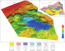
图1
珠江口盆地海丰33洼陷构造位置(a)(据文献[32]修改)与下文昌组沉积时期古地貌(b)"


图2
珠江口盆地地层综合柱状图(据文献[33]修改)"
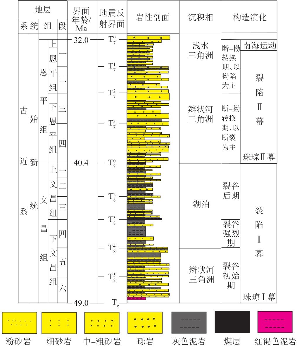
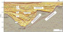
图3
海丰33洼陷断裂-挠曲坡折带特征(剖面位置见图1)"

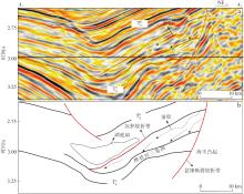
图4
海丰33洼陷沉积坡折带特征(剖面位置见图1)a.地震剖面;b.解释剖面"


图5
海丰33洼陷古沟谷刻画方法示意图(剖面位置见图1)"


图6
海丰33洼陷古沟谷形态特征(剖面位置见图1)"
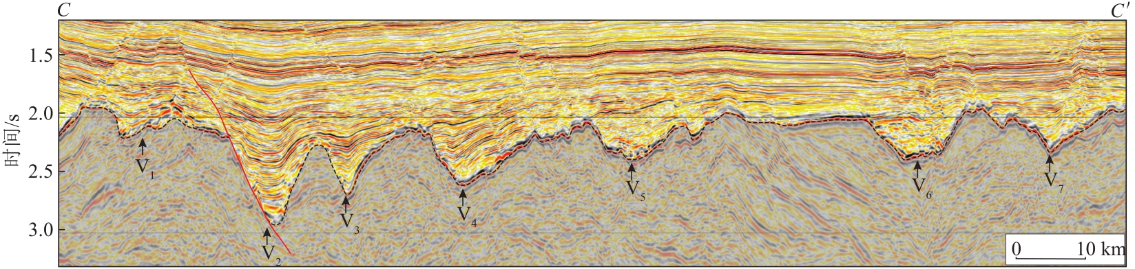
表1
海丰33洼陷陡坡带古沟谷和沉积体数据"
| 沟谷名称 | 沟谷类型 | 宽度/km | 深度/km | 宽深比 | 横截面积/km2 | 延伸长度/km | 坡度/(°) | 扇体面积/km2 | 扇体体积/km3 |
|---|---|---|---|---|---|---|---|---|---|
| V1 | W型 | 1.80 | 0.11 | 16.36 | 0.10 | 4.87 | 3.5 | 17.30 | 7.13 |
| V2 | 单断槽型 | 1.64 | 0.27 | 6.07 | 0.22 | 4.27 | 5.7 | 27.81 | 8.30 |
| V3 | V型 | 1.67 | 0.21 | 7.95 | 0.18 | 3.78 | 7.2 | 33.15 | 11.95 |
| V4 | V型 | 3.11 | 0.22 | 14.14 | 0.46 | 3.83 | 6.7 | 39.22 | 13.57 |
| V5 | U型 | 2.56 | 0.15 | 17.07 | 0.39 | 2.57 | 9.4 | 36.04 | 12.93 |
| V6 | U型 | 2.17 | 0.17 | 12.77 | 0.36 | 2.82 | 8.1 | 30.87 | 9.78 |
| V7 | V型 | 2.20 | 0.10 | 22.00 | 0.10 | 4.40 | 6.2 | 20.08 | 6.91 |
图7
海丰33洼陷陡坡带古沟谷与沉积体对应关系a.沟谷横截面积与扇体面积关系;b.沟谷横截面积与扇体体积关系;c.沟谷宽深比与扇体面积关系;d.沟谷宽深比与扇体体积关系;e.沟谷坡度与扇体面积关系;f.沟谷坡度与扇体体积关系;g.沟谷延伸长度与扇体面积关系;h.沟谷延伸长度与扇体体积关系"
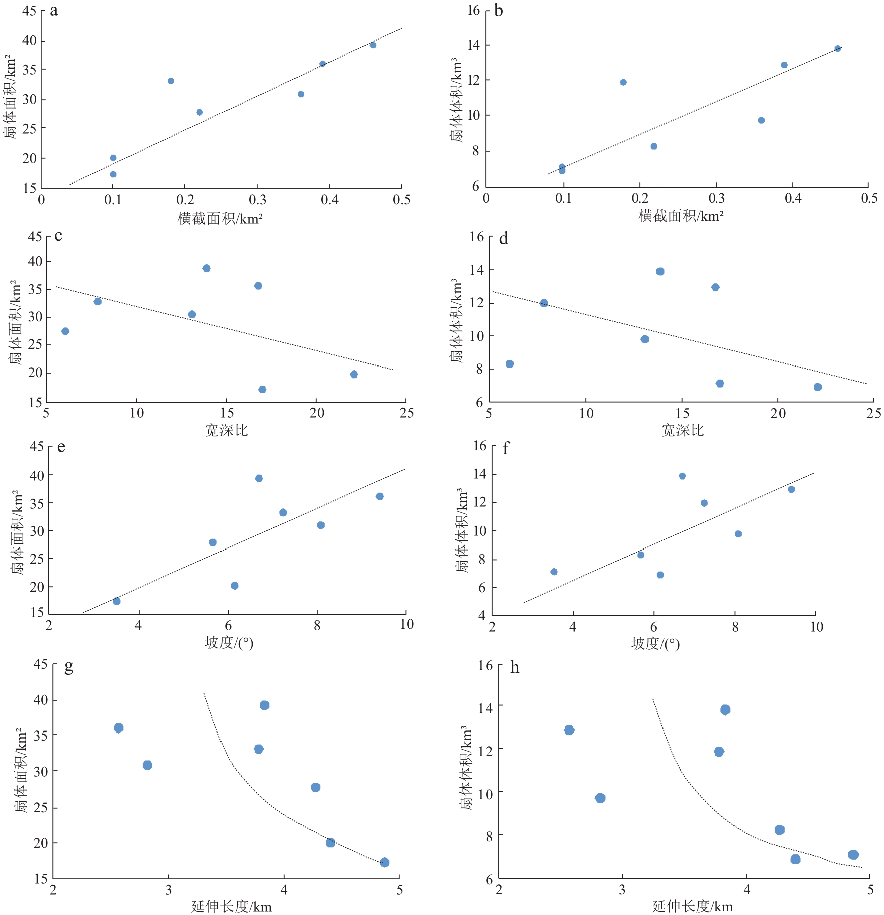
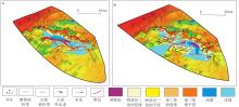
图8
海丰33洼陷文昌组沉积相a.下文昌组;b.上文昌组"
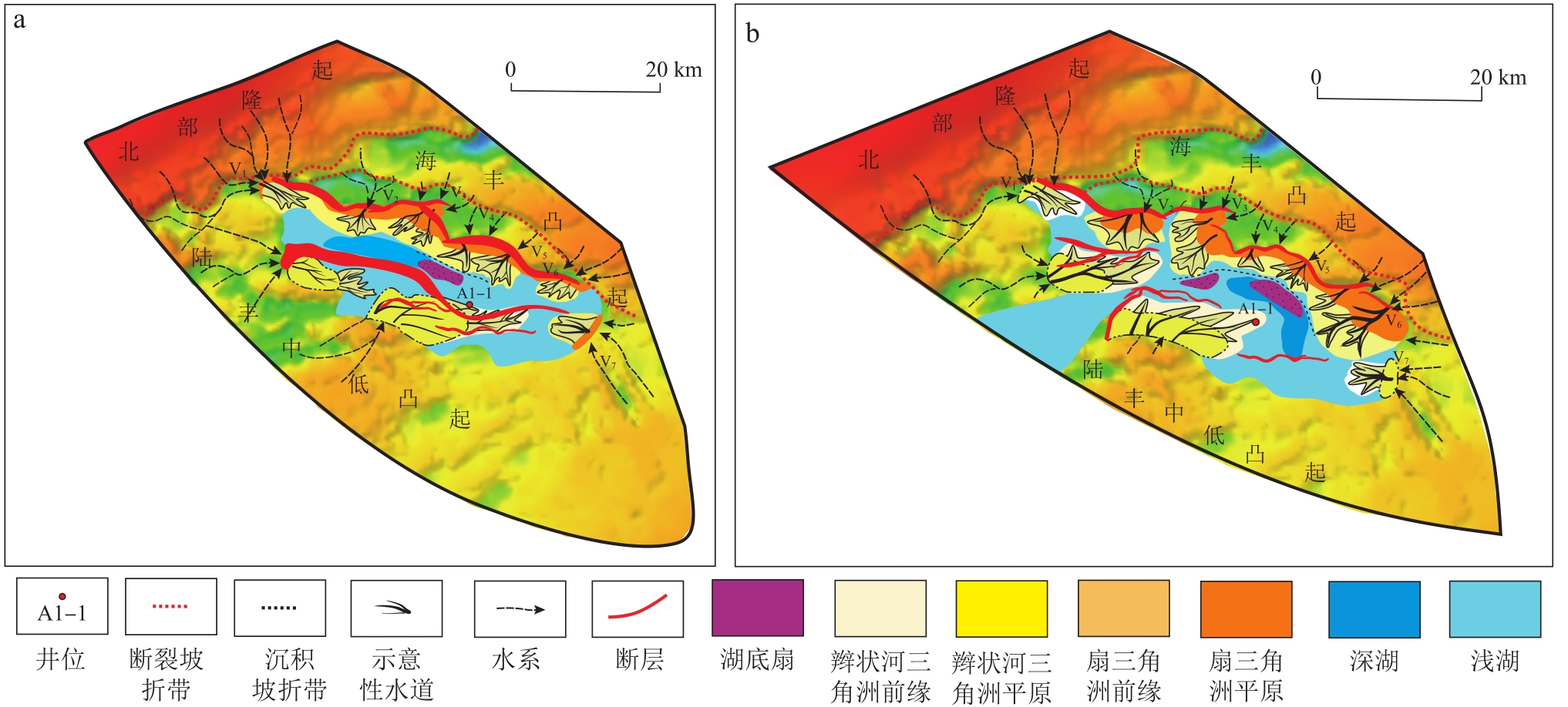
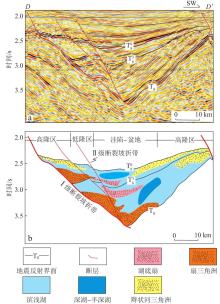
图9
海丰33洼陷文昌组地震层序-沉积体系解释(剖面位置见图1)a.地震层序界面;b.层序-沉积体系解释"

| 1 | 向淑敏, 李建平, 王根照, 等. 青东凹陷古近系沙三段中亚段构造-古地貌对沉积的控制[J]. 大庆石油学院学报, 2010, 34(1): 1-4. |
| XIANG Shumin, LI Jianping, WANG Genzhao, et al. Tectonic-paleogeomorphic controlled on deposition of Paleogene Es3m in Qingdong Sag[J]. Journal of Daqing Petroleum Institute, 2010, 34(1): 1-4. | |
| 2 | 辛云路, 任建业, 李建平. 构造-古地貌对沉积的控制作用——以渤海南部莱州湾凹陷沙三段为例[J]. 石油勘探与开发, 2013, 40(3): 302-308. |
| XIN Yunlu, REN Jianye, LI Jianping. Control of tectonic-paleogeomorphology on deposition: A case from the Shahejie Formation Sha 3 member, Laizhouwan Sag, southern Bohai Sea[J]. Petroleum Exploration and Development, 2013, 40(3): 302-308. | |
| 3 | 曾智伟, 杨香华, 舒誉, 等. 恩平凹陷古近系文昌组构造古地貌特征及砂体展布规律——少井条件下储集砂体预测与评价[J]. 现代地质, 2015, 29(4): 804-815. |
| ZENG Zhiwei, YANG Xianghua, SHU Yu, et al. Structure palaeogeomorphology characteristics and sand bodies distribution regularities of Paleogene Wenchang Formation in Enping Sag: Under the conditions of lack of drilling data to predict and evaluate the reservoir sand bodies[J]. Geoscience, 2015, 29(4): 804-815. | |
| 4 | 林畅松, 潘元林, 肖建新, 等. “构造坡折带”——断陷盆地层序分析和油气预测的重要概念[J]. 地球科学(中国地质大学学报), 2000, 25(3): 260-266. |
| LIN Changsong, PAN Yuanlin, XIAO Jianxin, et al. Structural slope-break zone: Key concept for stratigraphic sequence analysis and petroleum forecasting in fault subsidence basins[J]. Editorial Committee of Earth Science-Journal of China University of Geosciences, 2000, 25(3): 260-266. | |
| 5 | 刘豪, 田立新, 周心怀, 等. 断陷湖盆坡折体系与剥蚀沉积响应——以黄河口凹陷古近系为例[J]. 中国海上油气, 2017, 29(4): 28-38. |
| LIU Hao, TIAN Lixin, ZHOU Xinhuai, et al. Slope break systems of rift lacustrine basin and erosion-depositional response: A case study of the Paleogene in Huanghekou sag, Bohai Sea[J]. China Offshore Oil and Gas, 2017, 29(4): 28-38. | |
| 6 | LIU Hao, WANG Yingmin, XIN Renchen, et al. Study on the slope break belts in the Jurassic down-warped lacustrine basin in western-margin area, Junggar Basin, northwestern China[J]. Marine and Petroleum Geology, 2006, 23(9/10): 913-930. |
| 7 | LIU Hao, SOMERVILLE I D, LIN Changsong, et al. Distribution of Palaeozoic tectonic superimposed unconformities in the Tarim Basin, NW China: Significance for the evolution of palaeogeomorphology and sedimentary response[J]. Geological Journal, 2016, 51(4): 627-651. |
| 8 | 刘豪, 王英民. 准噶尔盆地坳陷湖盆坡折带在非构造圈闭勘探中的应用[J]. 石油与天然气地质, 2004, 25(4): 422-427. |
| LIU Hao, WANG Yingmin. Significance of slope break zones in downwarped lake basins to exploration of non-structural traps in Junggar Basin[J]. Oil & Gas Geology, 2004, 25(4): 422-427. | |
| 9 | 刘豪, 王英民, 王媛. 坳陷湖盆坡折带特征及其对非构造圈闭的控制[J]. 石油学报, 2004, 25(2): 30-35. |
| LIU Hao, WANG Yingmin, WANG Yuan. Characteristics of slope breaks and their control on atectonic traps in downwarped lake basin[J]. Acta Petrolei Sinica, 2004, 25(2): 30-35. | |
| 10 | 刘豪, 王英民, 王媛, 等. 大型坳陷湖盆坡折带的研究及其意义——以准噶尔盆地西北缘侏罗纪坳陷湖盆为例[J]. 沉积学报, 2004, 22(1): 95-102. |
| LIU Hao, WANG Yingmin, WANG Yuan, et al. Study on slope breaks in large down warped lake basins and its significance——A case study from Jurassic lake in northwestern Junggar Basin[J]. Acta Sedimentologica Sinica, 2004, 22(1): 95-102. | |
| 11 | 任宪军. 松辽盆地长岭断陷盆缘陡坡带中性火山岩相模式及其对储层的控制作用[J]. 吉林大学学报(地球科学版), 2022, 52(3): 816-828. |
| REN Xianjun. Faces Model of Intermediate Volcanic Rocks in Steep Slope and Its Control on Resevoirs: A Case Study in Changling Fault Depression, Songliao Basin[J]. Journal of Jilin University (Earth Science Edition), 2022, 52(3): 816-828. | |
| 12 | 李东海, 昝灵, 黄文欢, 等. 溱潼凹陷西斜坡阜三段隐蔽油藏勘探开发一体化实践[J]. 油气藏评价与开发, 2021, 11(3): 281-290. |
| LI Donghai, ZAN Ling, HUANG Wenhuan, et al. Exploration and development integration practice of subtle reservoir of 3rd member of Funing Formation in western slope of Qintong depression[J]. Petroleum Reservoir Evaluation and Development, 2021, 11(3): 281-290. | |
| 13 | 赵世杰, 傅强, 骆卫峰, 等. 溱潼凹陷西斜坡阜三段断陷湖盆砂质滩坝沉积特征[J]. 油气藏评价与开发, 2021, 11(2): 248-255. |
| ZHAO Shijie, FU Qiang, LUO Weifeng, et al. Sedimentary characteristics of sandy beach-bar in faulted-lacustrine-basin, Ef3 in west slope of Qintong Sag[J]. Reservoir Evaluation and Development, 2021, 11(2): 248-255. | |
| 14 | 宋昊, 胡明毅, 陈旭, 等. 不同坡度背景下生物礁沉积结构及差异演化特征: 以开江—梁平海槽西侧长兴组为例[J]. 断块油气田, 2022, (6): 788-793,799. |
| SONG Hao, Hu Mingyi, CHEN Xu, et al. Sedimentary structure and differential evolution characteristics of reefs under different slope backgrounds: a case study of Changxing Formation on the west side of the Kaijiang-Liangping Trough[J]. Fault-Block Oil and Gas Field, 2022, 29(6): 788-793, 799. | |
| 15 | 王予帆, 尹天豪, 丁毅, 等. 二连盆地阿尔凹陷东部陡坡带腾一下亚段重力流沉积特征[J]. 断块油气田, 2022, 29(4): 489-495, 538. |
| WANG Yufan, YIN Tianhao, DING Yi, et al. Sedimentary characteristics of gravity flow from lower submember of the first Member of Tengger Formation in the eastern steep slope belt of Aer Sag, Erlian Basin[J]. Fault-Block Oil and Gas Field, 2022,29(4): 489-495, 538. | |
| 16 | 郭美洁, 时保宏, 董雄英, 等. 黄骅坳陷埕海斜坡古近系油气成藏条件及主控因素[J]. 岩性油气藏, 2022, 34(3): 82-92. |
| GUO Meijie, SHI Baohong, DONG Xiongying, et al. Hydrocarbon accumulation conditions and main controlling factors of Paleogene in Chenghai slope, Huanghua Depression[J]. Lithologic Reservoirs, 2022, 34(3): 82-92. | |
| 17 | 周红飞, 戴鑫, 贾敏, 等. 川中古隆起北斜坡震旦系灯影组二段油气成藏特征[J]. 岩性油气藏, 2022, 34(5): 130-138. |
| ZHOU Hongfei, DAI Xin, JIA Min, et al. Hydrocarbon accumulation characteristics of the second member of Sinian Deng-ying Formation in the north slope of central Sichuan paleo-uplift[J]. Lithologic Reservoirs, 2022, 34(5): 130-138. | |
| 18 | 徐长贵, 赖维成, 薛永安, 等. 古地貌分析在渤海古近系储集层预测中的应用[J]. 石油勘探与开发, 2004, 31(5): 53-56. |
| XU Changgui, LAI Weicheng, XUE Yongan, et al. Palaeo-geomorphology analysis for the Paleogene reservoir prediction in Bohai Sea area[J]. Petroleum Exploration and Development, 2004, 31(5): 53-56. | |
| 19 | 辛仁臣, 李桂范, 向淑敏. 松辽盆地盆西斜坡白垩系姚家组下切谷充填结构[J]. 地球科学(中国地质大学学报), 2008, 33(6): 834-842. |
| XIN Renchen, LI Guifan, XIANG Shumin. The incised valley filling architecture of Cretaceous Yaojia Formation in the western clinoform of Songliao Basin[J]. Editorial Committee of Earth Science-Journal of China University of Geosciences, 2008, 33(6): 834-842. | |
| 20 | 何敏, 朱伟林, 吴哲, 等. 珠江口盆地新构造运动特征与油气成藏[J]. 中国海上油气, 2019, 31(5): 9-20. |
| HE Min, ZHU Weilin, WU Zhe, et al. Neotectonic movement characteristics and hydrocarbon accumulation of the Pearl River Mouth Basin[J]. China Offshore Oil and Gas, 2019, 31(5): 9-20. | |
| 21 | 朱明, 张向涛, 黄玉平, 等. 珠江口盆地烃源岩特征及资源潜力[J]. 石油学报, 2019, 40(S1): 53-68. |
| ZHU Ming, ZHANG Xiangtao, HUANG Yuping, et al. Source rock characteristics and resource potential in Pearl River Mouth Basin[J]. Acta Petrolei Sinica, 2019, 40(S1): 53-68. | |
| 22 | 施和生. 油气勘探 “源-汇-聚” 评价体系及其应用——以珠江口盆地珠一坳陷为例[J]. 中国海上油气, 2015, 27(5): 1-12. |
| SHI Hesheng. “Source-migration-accumulation” evaluation system and its application in hydrocarbon exploration: A case study of Zhu Ⅰ depression in Pearl River Mouth Basin[J]. China Offshore Oil and Gas, 2015, 27(5): 1-12. | |
| 23 | 张素芳, 张向涛, 汪旭东, 等. 珠江口盆地陆丰南地区文四段浊积岩沉积特征及勘探意义[J]. 科学技术与工程, 2017, 17(8): 115-120. |
| ZHANG Sufang, ZHANG Xiangtao, WANG Xudong, et al. Sedimentary characteristics and exploration significance of turbidity sandstones in the Wenchang IV Formation in south of Lufeng Depression in the Pearl River Mouth Basin[J]. Science Technology and Engineering, 2017, 17(8): 115-120. | |
| 24 | 陈长民, 施和生, 许仕策, 等. 珠江口盆地(东部)第三系油气藏形成条件[M]. 北京: 科学出版社, 2003. |
| CHEN Changmin, SHI Hesheng, XU Shice, et al. The forming conditions of Tertiary oil-gas reservoir in the eastern Pearl River in the Pearl River Mouth basin[M]. Beijing: Science Press, 2003. | |
| 25 | 葛家旺, 朱筱敏, 雷永昌, 等. 多幕裂陷盆地构造-沉积响应及陆丰凹陷实例分析[J]. 地学前缘, 2021, 28(1): 77-89. |
| GE Jiawang, ZHU Xiaomin, LEI Yongchang, et al. Tectono-sedimentary development of multiphase rift basins: An example of the Lufeng Depression[J]. Earth Science Frontiers, 2021, 28(1): 77-89. | |
| 26 | RU K, PIGOTT J D. Episodic rifting and subsidence in the south China Sea[J]. AAPG Bulletin, 1986, 70(9): 1136-1155. |
| 27 | PIGOTT J D, RU Ke. Basin superposition on the northern margin of the south China Sea[J]. Tectonophysics, 1994, 235(1/2): 27-50. |
| 28 | 刘海伦. 珠江口盆地珠一坳陷裂陷结构:基底属性与区域应力联合制约[D]. 武汉: 中国地质大学, 2018. |
| LIU Hailun. Rift style controlled by basement attribute and regional stress in Zhu Ⅰ Depression, Pearl River Mouth Basin[D]. Wuhan: China University of Geosciences, 2018. | |
| 29 | 郭伯举, 谢家声, 向凤典. 珠江口盆地珠一坳陷含油气系统研究[J]. 中国海上油气(地质), 2000, 14(1): 2-9. |
| GUO Boju, XIE Jiasheng, XIANG Fengdian. The study of the petroleum system in the Zhu I Depression in Pearl River Mouth Basin[J]. China Offshore Oil and Gas(Geology), 2000, 14(1): 2-9. | |
| 30 | 王碧维, 徐新德, 吴杨瑜, 等. 珠江口盆地西部文昌凹陷油气来源与成藏特征[J]. 天然气地球科学, 2020, 31(7): 980-992. |
| WANG Biwei, XU Xinde, WU Yangyu, et al. Oil-gas origin and accumulation characteristics of Wenchang Depression, western Pearl River Mouth Basin[J]. Natural Gas Geoscience, 2020, 31(7): 980-992. | |
| 31 | 吴克强, 刘志峰, 王升兰, 等. 珠一坳陷北部洼陷带始新统半深—深湖相烃源岩综合判识[J]. 中国海上油气, 2015, 27(3): 10-15, 24. |
| WU Keqiang, LIU Zhifeng, WANG Shenglan, et al. Composite recognition of Eocene semi-deep and deep lacustrine facies source rocks in northern subsags belt of Zhu Ⅰ Depression, Pearl River Mouth Basin[J]. China Offshore Oil and Gas, 2015, 27(3): 10-15, 24. | |
| 32 | 万琼华, 刘伟新, 王华, 等. 珠江口盆地陆丰凹陷辫状河三角洲前缘储层沉积构型模式[J]. 天然气地球科学, 2019, 30(12): 1732-1742. |
| WAN Qionghua, LIU Weixin, WANG Hua, et al. Research on sedimentary architecture pattern of braided river delta front of Lufeng Depression in Pearl River Mouth Basin[J]. Natural Gas Geoscience, 2019, 30(12): 1732-1742. | |
| 33 | 高阳东, 汪旭东, 林鹤鸣, 等. 珠江口盆地陆丰凹陷恩平组内部构造—沉积换面识别及意义[J]. 天然气地球科学, 2021, 32(7): 961-970. |
| GAO Yangdong, WANG Xudong, LIN Heming, et al. Characteristics and significances of the tectono-sedimentary transitional unconformity in Enping Formation of Lufeng Sag, Pearl River Mouth Basin[J]. Natural Gas Geoscience, 2021, 32(7): 961-970. | |
| 34 | 施和生, 何敏, 张丽丽, 等. 珠江口盆地 (东部) 油气地质特征、成藏规律及下一步勘探策略[J]. 中国海上油气, 2014, 26(3): 11-22. |
| SHI Hesheng, HE Min, ZHANG Lili, et al. Hydrocarbon geology, accumulation pattern and the next exploration strategy in the eastern Pearl River Mouth Basin[J]. China Offshore Oil and Gas, 2014, 26(3): 11-22. | |
| 35 | 葛家旺, 朱筱敏, 张向涛, 等. 珠江口盆地陆丰凹陷文昌组构造-沉积演化模式[J]. 中国矿业大学学报, 2018, 47(2): 308-322. |
| GE Jiawang, ZHU Xiaomin, ZHANG Xiangtao, et al. Tectono-sedimentation model of the Eocene Wenchang Formation in the Lufeng Depression, Pearl River Mouth Basin[J]. Journal of China University of Mining & Technology, 2018, 47(2): 308-322. | |
| 36 | 汪旭东, 林鹤鸣, 邱欣卫, 等. 低勘探区烃源岩SAS预测技术——以陆丰凹陷海丰33洼文昌组为例[J]. 地球物理学进展, 2022, 37(2): 882-891. |
| WANG Xudong, LIN Heming, QIU Xinwei, et al. Prediction of source rock based on SAS in an immature exploration area: A case study of Wenchang Formation in the Haifeng 33 Sag, Lufeng Depression[J]. Progress in Geophysics, 2022, 37(2): 882-891. | |
| 37 | 冯有良, 徐秀生. 同沉积构造坡折带对岩性油气藏富集带的控制作用——以渤海湾盆地古近系为例[J]. 石油勘探与开发, 2006, 33(1): 22-25, 31. |
| FENG Youliang, XU Xiusheng. Syndepositional structural slope-break zone controls on lithologic reservoirs——A case from Paleogene Bohai Bay Basin[J]. Petroleum Exploration and Development, 2006, 33(1): 22-25, 31. | |
| 38 | 王英民, 刘豪, 辛仁臣, 等. 湖盆坡折带——地层岩性圈闭勘探的新领域[J]. 石油科学(英文版), 2004, 1(2): 55-61. |
| WANG Yingmin, LIU Hao, XIN Renchen, et al. Lacustrine basin slope break——A new domain of strata and lithological trap exploration[J]. Petroleum Science, 2004, 1(2): 55-61. | |
| 39 | 邓宏文, 王红亮, 王敦则. 古地貌对陆相裂谷盆地层序充填特征的控制——以渤中凹陷西斜坡区下第三系为例[J]. 石油与天然气地质, 2001, 22(4): 293-296, 303. |
| DENG Hongwen, WANG Hongliang, WANG Dunze. Control of paleo-morphology to stratigraphic sequence in continental rift basins: Take lower tertiary of western slope in Bozhong Depression as an example[J]. Oil & Gas Geology, 2001, 22(4): 293-296, 303. | |
| 40 | 姜华, 王华, 肖军, 等. 应用古地貌分析方法进行有利区带预测——以琼东南盆地②号断裂带为例[J]. 石油勘探与开发, 2009, 36(4): 436-441. |
| JIANG Hua, WANG Hua, XIAO Jun, et al. Palaeogeomorphologic prediction of favorable zones: Take fault ② of Qiongdongnan Basin as an example[J]. Petroleum Exploration and Development, 2009, 36(4): 436-441. | |
| 41 | 谭建财, 范彩伟, 宋鹏, 等. 琼东南盆地中中新统古沟谷和坡折带特征及油气勘探意义[J]. 油气地质与采收率, 2017, 24(3): 30-36, 43. |
| TAN Jiancai, FAN Caiwei, SONG Peng, et al. Characteristics of the mid-Miocene paleo ravine-slope break zones in Qiongdongnan Basin and its significance for oil-gas exploration[J]. Petroleum Geology and Recovery Efficiency, 2017, 24(3): 30-36, 43. | |
| 42 | 李峻颉, 蒋一鸣, 侯国伟, 等. 坡折带对油气圈闭发育的约束效应——以平湖斜坡带孔雀亭区平湖组为例[J]. 海洋地质与第四纪地质, 2021, 41(3): 141-150. |
| LI Junjie, JIANG Yiming, HOU Guowei, et al. Constraints of slope break belt on oil and gas trapping——An example from the Pinghu Formation in the Kongqueting area of Pinghu Slope[J]. Marine Geology & Quaternary Geology, 2021, 41(3): 141-150. | |
| 43 | 朱红涛, 朱筱敏, 刘强虎, 等. 层序地层学与源-汇系统理论内在关联性与差异性[J]. 石油与天然气地质, 2022, 43(4): 763-776. |
| ZHU Hongtao, ZHU Xiaomin, LIU Qianghu, et al. Sequence stratigraphy and source-to-sink system: Connections and distinctions[J]. Oil & Gas Geology, 2022, 43(4): 763-776. | |
| 44 | 施和生, 高阳东, 刘军, 等. 珠江口盆地惠州26洼“源-汇-聚”特征与惠州26-6大油气田发现启示[J]. 石油与天然气地质, 2022, 43(4): 777-791. |
| SHI Hesheng, GAO Yangdong, LIU Jun, et al. Characteristics of hydrocarbon source-migration-accumulation in Huizhou 26 Sag and implications of the major Huizhou 26-6 discovery in Pearl River Mouth Basin[J]. Oil & Gas Geology, 2022, 43(4): 777-791. | |
| 45 | 谈明轩, 朱筱敏, 张自力, 等. 古“源-汇”系统沉积学问题及基本研究方法简述[J]. 石油与天然气地质, 2020, 41(5): 1107-1118. |
| TAN Mingxuan, ZHU Xiaomin, ZHANG Zili, et al. Summary of sedimentological issues and fundamental approaches in terms of ancient “Source-to-Sink” systems[J]. Oil & Gas Geology, 2020, 41(5): 1107-1118. | |
| 46 | 黄胜兵, 叶加仁, 朱红涛, 等. 渤中西环古沟谷与坡折带特征及其对储层的控制[J]. 海洋地质与第四纪地质, 2011, 31(1): 119-124. |
| HUANG Shengbing, YE Jiaren, ZHU Hongtao, et al. Characteristics of valley-slope break zone in the western circle of the Bozhong Depression and its control over reservoir distribution[J]. Marine Geology & Quaternary Geology, 2011, 31(1): 119-124. | |
| 47 | LIU Hao, MENG Jun, BANERJEE S. Estimation of palaeo-slope and sediment volume of a lacustrine rift basin: A semi-quantitative study on the southern steep slope of the Shijiutuo Uplift, Bohai Offshore Basin, China[J]. Journal of Asian Earth Sciences, 2017, 147: 148-163. |
| 48 | LIU Hao, A J (Tom) LOON, XU Jie, et al. Relationships between tectonic activity and sedimentary source-to-sink system parameters in a lacustrine rift basin: A quantitative case study of the Huanghekou Depression (Bohai Bay Basin, E China)[J]. Basin Research, 2020, 32(4): 587-612. |
| [1] | 张长建, 杨德彬, 蒋林, 姜应兵, 昌琪, 马雪健. 塔里木盆地塔河北部“过溶蚀残留型”断溶体发育特征及其成因[J]. 石油与天然气地质, 2024, 45(2): 367-383. |
| [2] | 黎瑞, 杨娇, 柴愈坤, 王华, 戴建文, 邓永辉, 孙爽, 马肖琳, 田腾飞. 大角度波浪控制下的浪成砂坝新模式[J]. 石油与天然气地质, 2024, 45(2): 530-541. |
| [3] | 张自力, 乔艳萍, 豆霜, 李堃宇, 钟原, 武鲁亚, 张宝收, 戴鑫, 金鑫, 王斌, 宋金民. 四川盆地蓬莱气区震旦系灯影组二段岩溶古地貌与控储模式[J]. 石油与天然气地质, 2024, 45(1): 200-214. |
| [4] | 远光辉, 彭光荣, 张丽丽, 孙辉, 陈淑慧, 刘浩, 赵晓阳. 珠江口盆地白云凹陷古近系深层高变温背景下储层成岩作用与低渗致密化机制[J]. 石油与天然气地质, 2024, 45(1): 44-64. |
| [5] | 史玉玲, 龙祖烈, 张向涛, 温华华, 马晓楠. 珠江口盆地恩平凹陷恩平17洼油气动态成藏过程[J]. 石油与天然气地质, 2023, 44(5): 1279-1289. |
| [6] | 朱红涛, 徐长贵, 杜晓峰, 刘强虎, 孙中恒, 曾智伟. 陆相盆地古源-汇系统定量重建、级次划分及耦合模式[J]. 石油与天然气地质, 2023, 44(3): 539-552. |
| [7] | 刘豪, 徐长贵, 高阳东, 林鹤鸣, 邱欣卫, 剧永涛, 汪旭东, 李磊, 孟俊, 阙晓明. 断陷湖盆低勘探区源-汇系统与烃源岩预测[J]. 石油与天然气地质, 2023, 44(3): 565-583. |
| [8] | 高阳东, 彭光荣, 张向涛, 汪旭东, 孙辉, 刘太勋, 孙丰春. 珠江口盆地白云凹陷古近系文昌组源-汇系统特征及演化[J]. 石油与天然气地质, 2023, 44(3): 584-599. |
| [9] | 刘军, 彭光荣, 郑金云, 蔡嵩, 朱定伟, 王梓颐. 珠江口盆地白云凹陷西区始新世张裂-拆离作用下沉积转换及源-汇响应[J]. 石油与天然气地质, 2023, 44(3): 600-612. |
| [10] | 彭光荣, 王绪诚, 陈维涛, 靳瑶瑶, 王菲, 王文勇, 全涵. 珠江口盆地惠州26洼东南缘古近系恩平组上段断-拗转换期源-汇系统及勘探意义[J]. 石油与天然气地质, 2023, 44(3): 613-625. |
| [11] | 王梓颐, 李洪博, 郑金云, 朱定伟, 于飒, 陈兆明, 李振升. 珠江口盆地番禺27洼裂陷期构造演化及其对源-汇系统的控制[J]. 石油与天然气地质, 2023, 44(3): 626-636. |
| [12] | 廖新武, 谢润成, 周文, 汪跃, 刘文超, 刘卫林, 程奇, 熊晓军, 罗紫薇. 古地貌对渤海湾盆地B区块太古宇暴露型潜山变质岩风化带储层裂缝发育的影响[J]. 石油与天然气地质, 2023, 44(2): 406-417. |
| [13] | 尹帅, 邬忠虎, 吴晓明, 刘建平, 谭成仟, 王濡岳, 袁慧, 戴亚威. 鄂尔多斯盆地陇东地区洪德区块侏罗系延安组油藏富集规律[J]. 石油与天然气地质, 2022, 43(5): 1167-1179. |
| [14] | 张向涛, 史玉玲, 刘杰, 温华华, 杨兴业. 珠江口盆地惠州凹陷古近系文昌组优质湖相烃源岩生烃动力学[J]. 石油与天然气地质, 2022, 43(5): 1249-1258. |
| [15] | 朱筱敏, 陈贺贺, 葛家旺, 谈明轩, 刘强虎, 张自力, 张亚雄. 陆相断陷湖盆层序构型与砂体发育分布特征[J]. 石油与天然气地质, 2022, 43(4): 746-762. |
| 阅读次数 | ||||||
|
全文 |
|
|||||
|
摘要 |
|
|||||